Modern
crop pictures and earthquakes: new evidence for a possible
relation
Modern crop pictures have been interpreted to signify many
different kinds of phenomena, for example planetary alignments,
solar flares, exploding comets, hurricanes, the BP oil spill, or
a nuclear power disaster at Fukushima. Few if any crop pictures,
however, have been ever been associated firmly with major
earthquakes.
That
situation changed on May 20, 2012, when a new crop picture
appeared at Bracciano in northern Italy. It showed complex
ground features, slight changes of magnetism, and anomalously
burnt plant stems (see
faenzashiatsu.it or
watch). Not far away on the same day (at almost the same
time), a major earthquake struck between Parma and Bologna. One
day later, there was an annular eclipse of our Sun, which
millions of people in eastern Asia or western North America
watched. Here we will search for any possible relations between
the Italian crop picture, those ongoing Italian earthquakes, and
a worldwide solar eclipse?
As
shown below, a new crop picture appeared at Bracciano (white
asterisk, above and to the left of San Marino) in the early
morning darkness of May 20, 2012. At almost the same time, 4:03
AM locally, a major 6.0 earthquake occurred in northern Italy
(yellow asterisk, to the right of Parma and above Bologna):
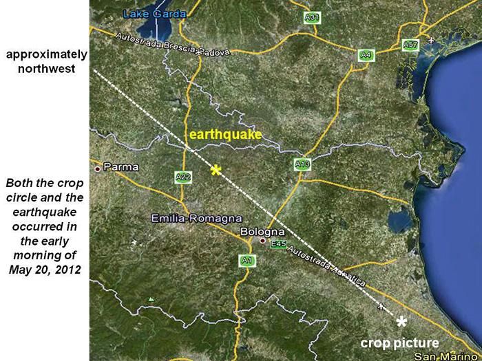
We
have drawn a dashed white line to illustrate a possible
geographic relation between the two events. It proceeds
approximately 100 km northwest from the crop picture to an
epicentre of the May 20, 2012 earthquake.
Now
if we look closely at the crop picture and its surrounding
terrain, we can see that it was drawn on the side of a steep
hill. That hill faces approximately northwest
toward where the earthquake struck 100 km away. Also, due to the
10o downward slope of that hill, the crop picture
points literally “down under the ground” toward
where the earthquake and its aftershocks took place, 5 to 10 km
deep in the Earth (see
news.discovery.com or
2012_Emilia_earthquake):
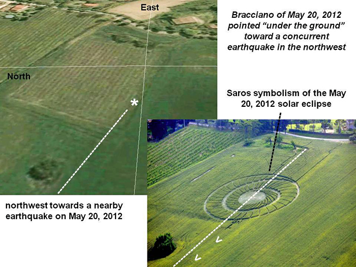
What
kind of image was drawn within that crop picture, and what might
it mean? The Bracciano crop picture showed an intricate two-turn
spiral, which may symbolize a “Saros cycle” for any long-term
series of eclipses. By counting the number of segments (71) in
that long spiral, as well as two (2) standing tufts in its
flattened centre, we were able to find a total of 73 standing
segments of crop. That is precisely the number of eclipses in
Saros cycle 128, to which the solar eclipse of May 20, 2012
belonged (see
Bracciano2012e). A small “flattened and twisted tuft” in its
very centre may have been meant to suggest an “axis of rotation”
about Earth’s north or south poles, where any Saros eclipse
cycle begins or ends.
Such
“eclipse symbolism” defines a date for which the
crop picture becomes relevant, namely May 20, 2012. Could those
crop artists have known about the northern Italy earthquake in
advance? If not, how could they have so carefully designed an
“eclipse spiral” motif, then laid it out on a steep hill, at
almost the same time as a major earthquake 100 km away, and
facing in the same general direction?
When
we study all three Italian crop pictures from May of 2012 on a
low-resolution map, we can see that they were laid out in the
approximate shape of a right-angled triangle (see
www.timestar.org ):

Riesi
appeared (behind a high locked fence) in Sicily on May 5,
Settimo in Sardinia on May 12, then Bracciano in northern Italy
on May 20. Other possible relations between crop pictures and
earthquakes have been noted in the past, covering broad regions
of the Earth from Indonesia to Mexico (see
triangles-earth-changes-watch ).
Yet never before has there been such a direct correlation as for
the Bracciano crop picture, which marked a nearly simultaneous
earthquake in northern Italy, only 100 km away.
In
summary, there does appear to be a possible relation between the
Bracciano crop picture, the northern Italy earthquake, and a
worldwide solar eclipse on May 20, 2012. That steep hill, upon
which the crop picture was drawn, may have been intended to
suggest where the earthquake would take place: to
the northwest and deep underground. Likewise its Saros eclipse
symbolism may have been intended to suggest when
the earthquake would take place: close to the date of a solar
eclipse one day later. There is no indication that the crop
picture was made to warn local people beforehand. It seems more
akin to a “timeline marker” than to a “warning” (see for example
www.remoteviewing.com).
Why
did they not draw a crop picture closer to the epicentre of that
earthquake, near Parma or Bologna? Well, the Bracciano crop
picture appeared only 10 km from the homes of several local
researchers. So close in fact, that it became easy for them to
investigate (see
Bracciano2012b).
Alternatively, those enigmatic crop artists may have wished to
suggest an approximate depth for that earthquake
and its aftershocks. If we assume a horizontal distance of 100
km between the crop picture and the earthquake, plus a vertical
depth of 5 to 10 km for the major earthquake and its
aftershocks, then we can calculate a downward angle of 3o
to 6o between Bracciano and a buried epicenter 100 km
away. The measured slope of that hill (on which the crop picture
was drawn) is actually 10o to 11o
downhill, not too far from the calculated values.
Red
Collie (Dr. Horace R. Drew) and Krsanna Duran
P.S.
Many thanks to Giando and Marina, who have provided most of the
field data for this very interesting Italian crop formation, and
are still investigating!
Appendix 1.
On May 29, 2012, a second major earthquake struck the same
region of northern Italy. Again it was 10 km deep in the Earth,
close to where the Bracciano crop picture “points” (see
http://edition.cnn.com).
Finally, a reliable local witness claims to have noticed, just
before midnight on May 19, two strange white lights flying up
into the sky, from the field where that crop picture was found
later on the morning of May 20, 2012 (see
Bracciano_Bertinoro).
Appendix 2. Clever field symbolism may have been used to
relate the time of the solar eclipse on May 21, 2012, to the
time of the first Italian earthquake on May 20, 2012
When you search on Google Earth for the field location of
that Bracciano crop picture, the first thing you see is a
large and unexpected “rectangle”. To be specific, you can
see that a “spiral” crop picture was laid down along the
right-hand side of a “rectangle in a field” (dashed red
lines below):
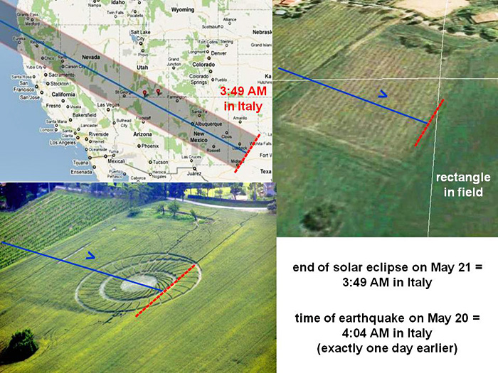
Why would they choose such a strange field location? Could
it have anything to do with the annular solar eclipse?
A map of the solar eclipse (upper left) shows that it also
ended along the right-hand side of a “rectangle”, at sunset
on May 20 in the western United States. That is equivalent
to 3:49 AM on May 21 in Italy. Interestingly
enough, the first Italian earthquake took place exactly one
day earlier at 4:04 AM on May 20.
By drawing a “spiral” in crops, representative of the “Saros
cycle” for a solar eclipse, along the right-hand side of a
field “rectangle”, were those crop artists trying to relate
an hourly time of 4 AM on May 21 for ending the solar
eclipse, to an hourly time of 4 AM on May 20 for the first
earthquake?
Three UFOs were photographed over Bologna, Italy on May 20
just after the earthquake, along with a rapidly moving disc
(see
watch or
www.youtube.com).
Appendix 3. The solar eclipse of May 20, 2012 belonged
to a Saros series with 73 eclipses, and was the only
recent eclipse series to match the number of standing
segments (73) in a crop picture which appeared at
Bracciano, Italy on the same day
The astronomical “Saros cycle” represents an 18-year
period between related eclipses, as they spiral westward
across Earth’s surface, either toward or away from
Earth’s poles. Within any “Saros series”, there may be
anywhere from 69 to 87 eclipses. The most common number
is 72, followed by 71 or 73:
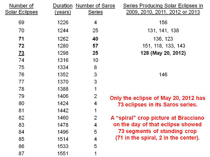
Now if we look just at recent solar eclipses from 2009
to 2013, we find that only the eclipse of May 20,
2012 belongs to a Saros series (128) which contains
73 eclipses. Most of the others contain 69
to 72, while one contains 76.
A “spiral” crop picture which appeared at Bracciano,
Italy on the same day showed 73 standing segments of
crop, as 71 in its two-turn spiral, plus 2 in its
flattened center (see
/Bracciano2012d or
Bracciano2012b). There is thus a close
correspondence between the May 20, 2012 solar eclipse,
its Saros series 128, and a Bracciano crop picture which
was found on the morning of May 20, 2012.
As further explanation, we can see below how
successive eclipses from any Saros series will
“spiral westward” around the surface of the Earth,
so as to match a two-turn “clockwise spiral” drawn
in crops at Bracciano:
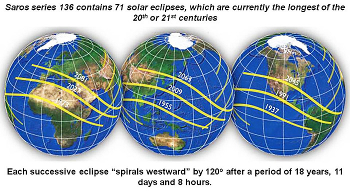
The eclipses shown in this diagram come from Saros
series 136, which is producing the longest solar
eclipses of the 20th or 21st centuries.
It contains 71 solar eclipses, the last of which
occurred on July 22, 2009. Saros series 128, which
produced the solar eclipse of May 20, 2012, contains
two more as 73.