UNITED STATES OF AMERICA CROP CIRCLES OF 2006 06 Formations |
Updated Wednesday 4th October 2006
Discus North American Crop Circles on the Forum
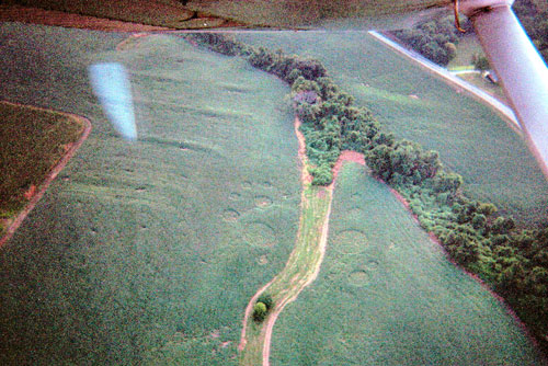
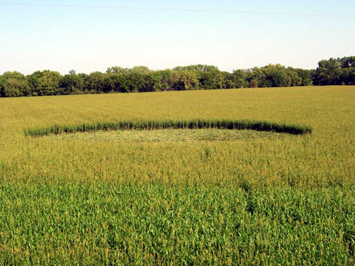
ICCRA Report – Beloit, Mitchell County, Kansas Crop Circle, Sept. 9, 2006
|
This is in Beloit Kansas, USA
I don't know anything about any of this
stuff, just that this is what we found one day beside the highway in
good old rural Kansas :) Sort of creepy even if you don't believe in
that sort of stuff.
|
|
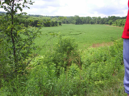
PRELIMINARY REPORT - BLT Research Team, 8/20/06
Location: Geneseo, Illinois (USA)
Crop: Soybeans (Round-Up Ready)
Date Formed: August 16, 2006 (?)
Date Found: August 17, 2006
Photos: qc times
Description: 5 circles total: 3 approx. 50' in diameter. abutting each other, 2 smaller circles (approx. 25' diameter.) on either side of centre circle. All circles swirled clockwise. The farmer (photo above) reports that neither he nor the Sheriff found any trail into circles on Aug. l9th when field was first examined and no evidence could be found of human involvement. He also reports that the plants were flattened (not broken) in 90-degree angles at the base and states that he doesn't think people made these circles. He adds that the plants are not dead and that, because of the height of leaf recovery back up toward the sun, it is his impression that the circles have not been there any longer than one week. The farmer does not have farm animals or dogs, but he has observed no unusual EM activity, no unusual smells or light phenomena during the last week. He was unaware that similar circles were found in a soybean field in Belleville, Illinois very recently.
BLT field personnel are en route and an update will be posted when we
have more information.
Nancy Talbott
BLT Research Team, Inc.
P.O. Box 400127
Cambridge, Massachusetts (USA)
ph: 617/492-0415
|
| Location: | 13566 North 2100th Ave, Geneseo, Illinois USA 61254 |
| Map: | |
| Crop: | Soybean Field |
| Description | Three 50ft interconnected circles in a linear fashion and two none connected 25ft Left & Right lateral circles arranged from the centre circle. Bottom of each plant seem to be sliced at an 80-degree angle with dark brown spotting around the incision area. In the normal field, soy plants are tightly planted and the soil seems to be dense and moist with no exposed patches. However, in each circle centre there is a dry patch of soil with no visible plant systems in a diameter of 1-2 feet. Round this was the A typical circle with the plants laying in a right-handed pattern and only a few inches thick from the ground. Even though it seems to rotate in a circular fashion, there are areas of each circle where the plants seem to be laying in a 1-3ft wide zigzagging pattern. This disturbance in the pattern was slight and did not interfere with the overall circular formation. |
| Discovery: |
8/19/06 by James Stahl (owner of the crop field) |
| Name: | Sean Connor |
| Status: |

Image Sean Connor Copyright 2006
|
Unusual Illinois Event
BLT Research Team Inc.
web:site:
www.bltresearch.com Preliminary Report -12 August 2006 Location:
Belleville, Illinois (USA)
|
|
UPDATE New Crop Circle Formation in Sandyville, Ohio I got back very late on Sunday (actually way early on Monday morning), so I haven’t had time to write our full report, but we did make a public statement on Sunday afternoon when we finished our investigation to the State Highway Patrol officer who was there (he was interested enough that he even took with him an ICCRA report on the 2003 Locust Grove-Serpent Mound formation after I showed him what anomalous damage looks like, and explained that we didn’t find it there), several press outlets (including Fox 8) and the gathered visitors at the crop circle site. We found evidence consistent with what we have seen in mechanical man-made formations (including board marks, broken stalks in areas where visitors had not trampled, scrape marks on stalks from a board, and pathway “artifacts” left from the mechanical creation process), and we found no anomalies (no unusual plant damage, completely normal radiation and E-M fields, etc…) unlike what we have seen in previous non-man-made formations in soybeans. Essentially, we determined the formation to be man-made. I’ll be putting out a fuller report with photos of the evidence as soon as I can (probably later today). Late yesterday, we were told by locals that the Tuscarawas County Sheriff’s Department was saying that they ‘had caught / arrested’ 4 individuals (two adults, two underage teens) responsible for making the formation. Several local news outlets are now reporting on the “confession,” and their slant is that the “UFO investigation” is now deflated, and that these hoaxer kids are so upstanding, they are coming forward to make restitution to the farmer and that they feel bad they caused so much trouble: http://www.ohio.com/mld/ohio/news/15116008.htm http://www.timesreporter.com/index.php?ID=56553&r=5 Neither of the above two articles mentions ICCRA involvement or our findings, which may be a little odd considering the amount of attention we received there, and the number of media people we talked to. The first story names some unnamed person who supposedly took a Geiger counter into the field and reported radiation – this was certainly not us, as we detected normal levels of radiation, electric fields, and magnetic fields. The second story quotes the Sheriff as saying some crop circle researchers got argumentative with him when he told them it was hoaxed – again, I’m not sure who he is referring to, but that also clearly wasn’t us as our only contact with the local Sheriff’s Department was two phone calls – the first to find out the location and to determine if they had conducted an investigation (they had, but their weren’t releasing any information about it), and the second time was to notify them that we had contacted the farmer and left a message for him and were waiting for his permission before we would enter the field (we subsequently located the landowner who did give us written permission to enter the field) and the conversations were polite and brief (they seemed like they were fielding a lot of calls on this). I also made a statement to a reporter from the local paper before the news broke on the hoaxers asking that if anyone has any information on who may have hoaxed the formation to contact the local sheriff because this was a serious amount of money the farmer stands to lose (soybeans are around $6-$7 a bushel / low avg. of 50 bushels of soybeans per acre; the formation was approx. 230’ long x 130’ wide + all the visitor tracks – makes this more well more than an acre of crop lost. It could be close to $1,000 or more of damage). This is criminal property damage and criminal trespass, and that whoever is responsible needs to be prosecuted to the fullest extent of the law, to prevent this kind of thing happening in the future. Hopefully, people will also learn that we can make a determination between mechanically man-made formations and ‘authentic’ ones (non-man-made) and this will cut down on future hoaxers too. By the way, this is now the second hoaxed crop circle formation in north-eastern Ohio in the past month. We also investigated a single circle attempt in a mixed grass/shrubs field in Newbury, Geauga County, Ohio reported on July 7. We identified that one clearly as a hoax within minutes of arriving (same reasons as above). Hopefully this isn’t becoming a trend up there! Feel free to pass this on to anyone you feel may be interested… Jeffrey Wilson |
|
New Crop Circle Formation in Sandyville, Ohio MORE DETAILS TO FOLLOW On Saturday morning July 22, a new crop circle formation was reported near the small village of Sandyville, Tuscarawas County, Ohio (thanks to Delores and Sharon for notifying us and providing us with good details!). The formation was not in the field on Friday at 7 PM when Sharon went past the field on her way home. Friday night / early Saturday morning there were fierce storms with heavy rain and wind that hit the region, and many nearby areas are now flooded. The formation was spotted in the field on Saturday morning and reported to the Tuscarawas County Sheriff’s Department and to several local media outlets. The Tuscarawas County Sheriff’s Department sent out a deputy to investigate, and he has been reported as saying that upon entering the field, the only footprints he found were his own -- while he walked the formation.
The formation is a soybean field, and the soybeans are 1-2 feet tall (relatively short as it is still early yet for soybean growth in Ohio). The field is located along the banks of the Nimishillen Creek (still very swollen as seen in the photos) just above where it merges with Sandy Creek. The formation consists of two main components: (1) a ‘bullseye’-shaped symbol with two flattened rings surrounding a smaller flattened circle with quadrant-spaced flattened pathways connecting the rings and circle; and (2) a single circle. Even though this formation is less than 24 hours old, it has already suffered much pedestrian traffic, with at least 9 separate pathways streaming into the formation, and a section of soybeans flattened down by a 4-wheeler in a “curly-q” shape near an access lane. It is also unclear whether the pathway connecting the “bullseye” and the second circle was part of the formation originally, or came as a result of visitors. As word got out about the formation, ICCRA member Chris Steele arranged us a photo flight, and we made it over the formation just before sunset. Through light rain was falling, and with the daylight fading as we arrived at sunset, I managed to get several photos: Several members of the ICCRA will be meeting at the formation site to attempt to conduct ground investigations on Sunday, July 23. Hopefully the damage won’t be too extensive and we will be able to get some worthwhile data. We will keep everyone informed as information is collected…
Jeffrey Wilson Director, ICCRA – Independent Crop Circle Researchers’ Association [International] jeff.wilson@asmnet.com or jeff.wilson@adelphia.net Independent Crop Circle Researchers’ Association (International) [ICCRA] The Independent Crop Circle Researchers’ Association (International) [ICCRA] began as a small cooperative group of individuals in the Midwestern United States who have long pursued serious research into the crop circle phenomenon with the principle of open collaboration. This ‘team’ of researchers has steadily grown in number, and has now included contributions from members of the crop circle research community from around the world. Although all the researchers in this association are considered independent (and thereby retaining individual ownership of their work), the investigative community has recognized that the study of the various complexities and aspects of the crop circle phenomenon are beyond the abilities and resources of any one researcher or local group to study in sufficient depth. Hence, the need for a cooperative association and network dedicated to the widest and freest possible collection and dissemination of crop circle research. The ICCRA recognizes the need in the research community to collect and make available as much objectively verifiable knowledge and details about crop circles as possible, and so will continue to study and document crop formations using a scientific framework. The ICCRA is committed to working cooperatively with local farmers, respecting their property and conditions for granting permission and access to their fields, and can provide experienced consultation as to the ways they can cope with the existence of having a crop circle in their field. We are also committed to working cooperatively with law enforcement agencies to assist them in assessing and investigating reported crop circles, exposing the vandalism of crop circle hoaxers, and assisting with advice on the management of visitors to the crop circle sites. The ICCRA began as a ‘core’ group of individuals cooperating as a rapid response team reacting to reports of local crop circles in order to study and document them. The ICCRA has recognized the need to expand the response network to include as many interested researchers as possible. To facilitate this network, the ICCRA has begun a researcher directory so that when a crop circle is reported, the closest local investigators will be notified. This will provide the best opportunity to investigate and document the site, and also gives the wider, international community a contact-resource for information and interaction in real time. The ICCRA’s highest priority is the sharing of information and research with the wider research community. Reporting and sharing of news and field reports of formations is being carried out through www.cropcirclenews.com. To help standardize report information, researcher access to a worldwide crop circle database with professional-level GIS mapping capability is also being developed at this website which will not only document and share the information collected in a systematic manner, but will also provide new research opportunities. This research center will also serve as a depository of information collected on historical sites, scientific reports, photos, previous field reports, the researcher directory, and links to further crop circle resources. Many independent researchers have amassed valuable files over the years regarding this phenomenon. We encourage all such researchers to use this opportunity to enrich the wider community with your archived knowledge, while at the same time retaining ownership and credit for your years of effort. All interested researchers, and both new and previously established organizations and networks are invited to join this cooperative and collaborative effort to locate, study, document, and share information about crop circle formations, regardless of each individual’s personal hypothesis regarding the source cause of the authentic crop circle phenomenon, or their affiliations with any organizations.
Click on thumbnails to enlarge Images Patricia Hagy Copyright 2006 |
Huntingburg, Dubois County, Indiana
by Jeff Wilson
UPDATE
|
There are several diagrams of the Huntingburg, Indiana, USA formation that I’ve seen floating around now, most of them are quite inaccurate. Based upon the measurements made over this past weekend by ICCRA members Ted Robertson, Roger Sugden, and myself, I’ve put together a more accurate silhouette diagram and also one with accompanying geometry that seems implicit in the formation. Our ICCRA team is still analyzing the sampling and meter data, and we hope to have results soon. But I wanted to send this out before our report to correct some of the inaccuracies out there. I’d also like to point out one additional interesting detail – both ends of both of the ľ rings flowed into the main circle. The point in the rings at which the flattened lay diverged in opposite directions (one direction uphill, the other downhill) was along the central axis marked in magenta on the left diagram. Lots of additional interesting details, so more to come. Jeffrey Wilson Director, ICCRA Independent Crop Circle Researchers’ Association
|
|
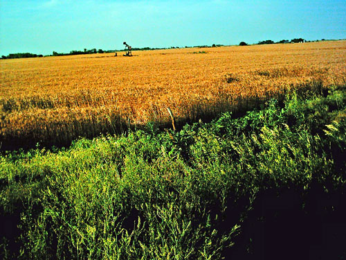
Crop Circles Appear In Huntingburg
"This was really kind of impressive. You hate to lose the crop, but it was kind of impressive, the way they did the design." David Ring is having a little fun with this one. He's been farming in Huntingburg for more then ten years and never seen anything quite like this - a huge crop circle in the middle of his wheat field. "First I thought it was where sometimes, when you apply nitrogen to weed it goes down on its own, but this was just too perfect a circle."
Click on Thumbnail to enlarge A perfect circle, complete with a design, about 150 feet in diameter. Ring says, "Somebody spent a lot of time working on this, because it was done to perfection, if you will, on this project." The circle looks impressive in the aerial photos, but from the ground, it's even more impressive - especially the way the wheat lays so flat against the ground.
Click on Thumbnail to enlarge This part of Huntingburg is quite rural, but well travelled, with the airport near Ring's fields. So how did this huge circle, in the middle of a wheat field in Dubois County, get there?
Ring tells us, "It took either one person or several people lots of hours to roll that much weed down - or the aliens - maybe it was them, who knows?" And maybe we'll never know. Ring's story is now the talk of the town - it even made the front page of the local newspaper. It's certainly something people will be talking about for some time to come. Source
http://www.14wfie.com/Global/story.asp?S=5095329&nav=3w6o
|
|