|
Huntingburg, Dubois County, Indiana by Jeff Wilson |
Updated Saturday 1st July 2006
Discus North American Crop Circles on the Forum
|
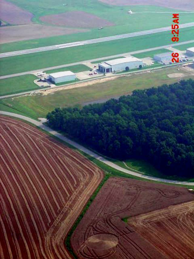
Click on Thumbnail to enlarge (All aerial photos by Travis McQueen ñ Manager, Huntingburg Airport ñ with permission). The formation was discovered on Sunday, June 25, 2006 by farmer David Ring while harvesting the field. Based on his estimate of the continued growth of the standing plants vs. the flattened ones, Mr. Ring believes that formation could have been 1-2 weeks old by the time it was spotted on the 25th, but no reliable date earlier than this time can be established. The formation is in a peculiar spot in the field; it lies on a small slope facing away from the nearby access road, about 300 feet away. Mr. Ring notes that they couldnít see it from that vantage point, and it only became noticeable when they came upon it while harvesting was it possible to see it. We believe that although it is very close to the nearby airportís runways, and you would think would be spotted or reported quickly (property is adjacent to the Huntingburg Airport), it may have not been due to it being perpendicular to the runway and therefore not easily visible from behind a nearby grove of trees (see photo below). Travis McQueen, the manager from the adjacent Huntingburg Airport, managed to get a series of photos before the formation was cut:
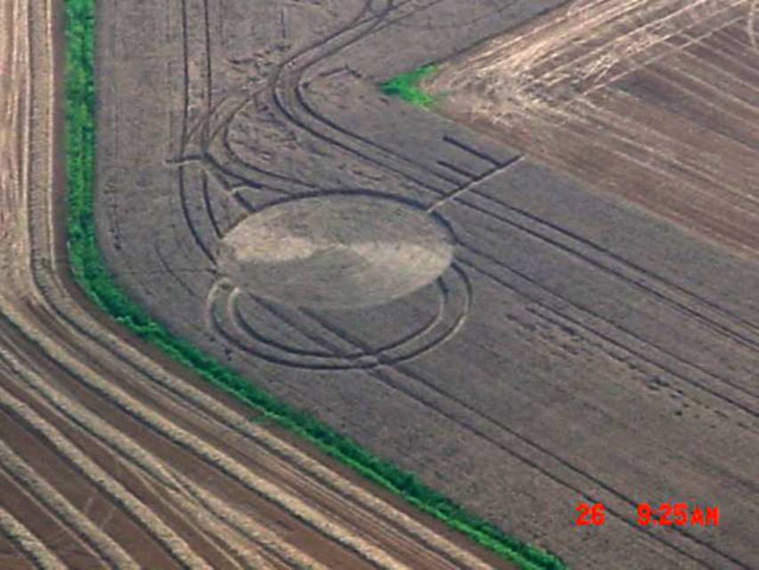
Click on Thumbnail to enlarge This photo shows the proximity of the circle to the nearby Huntingburg Airport, and showing how it was perpendicular to the runways. Although the field has been cut, the ICCRAís Ted Robertson has already done a preliminary ground investigation, with the main tests and a full survey to be conducted later today with additional members of the ICCRA. The formation consists of a 99 foot diameter main circle, generally swirled counter-clockwise, but with several sections diverging from the main flow like this:
////////// \\\\\\\\\\ ////////// \\\\\\\\\ You can see this in Ted Robertsonís photo below:
Click on Thumbnail to enlarge While this is not exactly the same ìherringbone weaveî effect as the irregular square flattened formation from Pattersonís Corner, Greene County, Ohio reported on July 5, 2005 it nonetheless is an interesting divergence of flow in the circle.:
Click on Thumbnail to enlarge Other sections of the formation include two æ rings on the south side of the circle approximately 3 feet wide, which give the appearance from the air of being full rings which have been overlapped by the main circle creating an invisible vesica pisces. This partial rings, or as farmer David Ring calls ìthe handlesî, do not appear to have extended their pathways underneath the main lay, but begin right at the circleís perimeter. These ëhandleí pathways are slightly larger than the nearby tramlines, and were at first mistaken as four-wheeler tracks by Mr. Ring, but after closer inspection, he realized that they could not have been created in that fashion. The diameter of the outer ring is very similar in size to the diameter of the main circle, but exact measurements will be taken later today. Also extending off the main circle are two straight pathways with small spurs branching off the main line. The main pathway to the east is a backwards ìFî-type key, with the main pathway approximately 3 feet in diameter and 66 feet in length. This pathway extended right to the edge of the field, with the flattened wheat breaking the edge of the standing crop, and lying out into a grass/weeds buffer area between two fields. The two spurs extending towards the north off this pathway were 2 Ω feet and 1 æ feet in diameter. The second pathway is approximately 50 feet in length, but interestingly tapers down to a sharp point at itsí northernmost end away from the main circle. Along itsí length are two spurs ñ facing opposite directions. This second pathway to the NNE is not aligned to the geometric centre point of the main circle, but interestingly to the centre point of the invisible vesica pisces created by the design. It also appears that there may have been a small L-shaped segment located to the northeast of the formation. Also in the direction was a series of randomly-downed, partially flattened wheat (RDF), although this section has been severely cut, making further investigation of this area difficult. Formations often appear amidst areas of RDF. Located along the western edge of the formation is a drainage creek with flowing water. No immediate unusual weather was reported in the area prior to the formationís discovery for at least 8 days, although severe storms did knock out power to the airport and to local residents several times in the 7-10 day period prior to the discovery. It is possible that this timeframe is consistent with Mr. Ringís evaluation that the formation had been there 1-2 weeks before they found it. The Huntingburg Press reported a crop circle in the area northeast of the town in March of 1998, and another crop circle was reported approximately 20 miles to the south in Troy, Spencer County, Indiana back in July of 1994 -- so the area has not been unknown to crop circles previously. A full survey with Mr. Ringís kind permission will be conducted beginning today, with plant and soil samples to be collected. Ted Robertson has already managed to collect control samples from areas of still-standing stalks left at the margins of the field, so we anticipate that the L-NEAT can be performed. Also, magnetometer, radiation, E-M, and microwave readings will be taken, and all results will be posted at www.cropcirclenews.com as time permits. Sincerely, Jeffrey Wilson Director, ICCRA ñ Independent Crop Circle Researchersí Association [International] jeff.wilson@asmnet.com or jeff.wilson@adelphia.net 734-891-2689 (cell) Independent Crop Circle Researchersí Association (International) [ICCRA] The Independent Crop Circle Researchersí Association (International) [ICCRA] began as a small cooperative group of individuals in the Midwestern United States who have long pursued serious research into the crop circle phenomenon with the principle of open collaboration. This ëteamí of researchers has steadily grown in number, and has now included contributions from members of the crop circle research community from around the world. Although all the researchers in this association are considered independent (and thereby retaining individual ownership of their work), the investigative community has recognized that the study of the various complexities and aspects of the crop circle phenomenon are beyond the abilities and resources of any one researcher or local group to study in sufficient depth. Hence, the need for a cooperative association and network dedicated to the widest and freest possible collection and dissemination of crop circle research. The ICCRA recognizes the need in the research community to collect and make available as much objectively verifiable knowledge and details about crop circles as possible, and so will continue to study and document crop formations using a scientific framework. The ICCRA is committed to working cooperatively with local farmers, respecting their property and conditions for granting permission and access to their fields, and can provide experienced consultation as to the ways they can cope with the existence of having a crop circle in their field. We are also committed to working cooperatively with law enforcement agencies to assist them in assessing and investigating reported crop circles, exposing the vandalism of crop circle hoaxers, and assisting with advice on the management of visitors to the crop circle sites. The ICCRA began as a ëcoreí group of individuals cooperating as a rapid response team reacting to reports of local crop circles in order to study and document them. The ICCRA has recognized the need to expand the response network to include as many interested researchers as possible. To facilitate this network, the ICCRA has begun a researcher directory so that when a crop circle is reported, the closest local investigators will be notified. This will provide the best opportunity to investigate and document the site, and also gives the wider, international community a contact-resource for information and interaction in real time. The ICCRAís highest priority is the sharing of information and research with the wider research community. Reporting and sharing of news and field reports of formations is being carried out through www.cropcirclenews.com. To help standardize report information, researcher access to a worldwide crop circle database with professional-level GIS mapping capability is also being developed at this website which will not only document and share the information collected in a systematic manner, but will also provide new research opportunities. This research center will also serve as a depository of information collected on historical sites, scientific reports, photos, previous field reports, the researcher directory, and links to further crop circle resources. Many independent researchers have amassed valuable files over the years regarding this phenomenon. We encourage all such researchers to use this opportunity to enrich the wider community with your archived knowledge, while at the same time retaining ownership and credit for your years of effort. All interested researchers, and both new and previously established organizations and networks are invited to join this cooperative and collaborative effort to locate, study, document, and share information about crop circle formations, regardless of each individualís personal hypothesis regarding the source cause of the authentic crop circle phenomenon, or their affiliations with any organizations. |