|
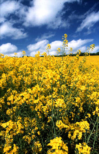
Pole shot of the Furze Hill Triangles © Steve Alexander 2000 |
|
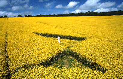
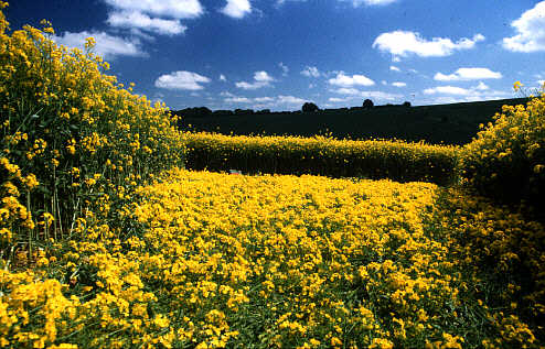
CROP CIRCLES IN THE YEAR 2000 - Steve Alexander & Karen Douglas share some of their recent crop circle experiences in this unique and beautifully illustrated series, exclusive to the Crop Circle Connector THE FURZE HILL TRIANGLES By Steve Alexander & Karen Douglas May 2000 Link here to further reports and illustrations on the Crop Circle Connector Circles in 2000 On Saturday the 13th of May we had been out and about in the Wiltshire landscape in search of the remains of Falkner’s Circle, a small stone circle not far from the Avebury Avenue (see up and coming article and pictures – Late May 2000). We had been successful in our quest and had returned home that evening filled with a certain amount of achievement. As Sunday morning began in earnest we learned to our surprise that a new formation had been discovered at Furze Hill. Many were of the opinion that this formation probably happened on the Saturday, but we had not seen a thing as we had driven past the field on our way home yesterday. |
|
Pole shot of the Furze Hill Triangles © Steve Alexander 2000 |
|
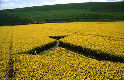
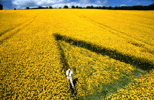
Strange Birds & Sailing Ships. Monday’s crystal blue skies were dotted with bright silver clouds drifting gracefully like huge ships sailing across the sparkling ocean. There was a dream like quality to the day, slow, gentle and slightly surreal, a perfect day, in fact, for visiting a new formation. We waded through the yellow waters of the landscape, upwards, and towards a weird and wonderful island where we would rest a while and roost like strange birds. More Triangles Our island was in the shape of two triangles, the larger of the two measuring 49ft x 49ft x 28ft, the smaller, 21ft x 21ft x 21ft. A corner of one triangle touched the corner of the other - creating a line on which both shapes were locked. This line deviated from North/South by only a fraction and was placed at a diagonal across the field. |
 |
 |
|
Poles shots of Larger Triangle (above) & View from the Top of the Field (below) Images © Steve Alexander 2000 |
|
|
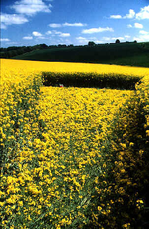
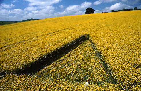
| The larger of the triangles had a straight and slightly radiating lay. The crop was brushed along the shorter base of the triangle for about 1.5ft, then the remaining crop was swept from the base, rushing towards the apex creating a beautiful carpet of oilseed rape flowers. Standing at this apex, we caught site of a wonderful view of Knap Hill across the sea of the yellow field, it was as if this vista had been by design this particular apex falling just at the right elevation in the field to create the effect. |
|
|
Right – Lay of crop running towards the apex of the larger triangleLeft – Inspecting the lay closer to ground level Images © Steve Alexander 2000
|
|
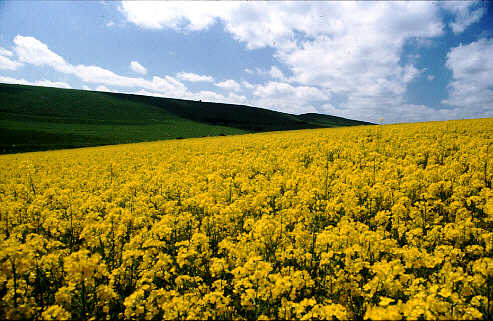
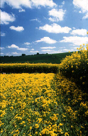
View from the apex of the larger circle with Knap Hill © Steve Alexander 2000 |
|
The smaller triangle, lower in elevation in the field, had a loose spiral-like pattern to the lay, moving in a clockwise motion from the centre, then becoming more lateral along the straight sides of the triangular shape. This was somewhat damaged before our arrival, as were many of the plants, but not so much as to prevent our appreciation of the simple aesthetic beauty presented by the formation. As strange as this pattern was it had a certain amount of power to it. Standing at the lowest corner of this smaller triangle |
 |
| our eyes were drawn down the field and then up the rise on the other side of the road. We decided we would explore this on the map on returning home, we wondered where the rise would take us if we followed the line of sight through. |
|
|
Personal Notes: Sitting quietly inside the formation, eyes raised to the blue, I watched those graceful sky-boats make their windblown passage across the firmament towards the horizon. It was a scene of harmony and tranquility. From my little boat in the yellow sea, I could now imagine floating gently with the tide and the movements of the earth, following in the wake of those beautiful vessels and wondering where they might lead me. Yellow meets the Blue - © Steve Alexander 2000
|
| SOME HISTORY OF THE
AREA…
The Langdean Circle Back at home we dug out our books and maps. Following the Ridgeway towards the Wandsdyke, over Furze Hill lies a litter of Sarsen stones. Once called "Stoneyfield" this was thought to have been a small stone circle of particular interest. There are also accounts of two roughly parallel rows of stones 10-13 yards apart and running for 45 yards joining the Eastern side of the circle. The site unfortunately is now inaccessible, but we could walk along the Ridgeway and look down into the coombe where the stones are. The site was given the official title of the Langdean Circle, or the Thorn Hill Circle. Not much is known about the circle, how large it was or even when it had been destroyed, but we had felt there was something about this place that was ancient and special, we were delighted, but not surprised that this place had once housed an ancient site. This area is also referred to as Red Shore because of the red earth of the landscape here. Shaw Village Following our line of sight from the small triangle, we found the abandoned and mysterious medieval village of Shaw. Shaw was originally an old Saxon village and has now been abandoned for many hundreds of years. The last mention of people inhabiting the village was in the 1300’s. Shaw is a mysterious village in the fact that there seems to be no records about the village anywhere including the public records office. The remains of a church at Shaw have also been discovered, the church was situated near to Shaw Copse and according to excavations would have measured 22ft by 40ft and would have seated around 50 parishioners. One window was found which indicated the church would have dated to the 1300’s however this could have been inserted as a new addition to a much older church. The village has never been fully excavated and now is mostly covered with trees. The main street of Shaw however can still be seen, but as little more than a sunken trench. Shaw village is now accessible by a permissible path with agreement of the landowner. With all this history around our site, we knew a follow-up visit would be in order to fully appreciate the landscape in which this formation had appeared. It was as if this small formation had been, in part, an invitation to explore a part of the landscape that we would never have otherwise known about. Steve Alexander & Karen Douglas Have you seen the CROP CIRCLE YEAR BOOK 1999A pictorial tour of crop circles and their landscapes By Steve Alexander & Karen Douglas? |