Whiskey Hill, Oregon. Reported 23rd July
Updated Wednesday 21st April 1999
Image by Sherry Ardinger Copyright 1999
Field Report
This is to confirm a new major pictogram
formation in Oregon, located at Whiskey Hill. Was on the Channel 6 news Wednesday night,
and Mike Downey of MUFON called me about it. Keith Ardinger and I spent yesterday, July
23 researching and mapping the formation. We flew over in the evening and got some aerial
photos. It is a lovely design to see from the air!!
We located the farmer and he did not know it was in his field. It is not visible from the
highway. He led the way into the field and we were the first to enter it. It appears
genuine. From the air there are absolutely no pathways but the one we made. The field has
no irrigation or fertilisation lines, there is nothing but 33 acres of sparsely sown
wheat. Wheat field was planted as dairy cow feed. He will harvest in about 2 weeks. One
interesting feature of field is it is located where major power lines converge from two
directions.
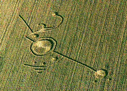
The design is hard to describe but has a major ringed circle with two long pathways plus
some arched pathways leading off of those, plus outer circles spread along the distance
and one grapeshot quite a distance away. It is a delightful design and very picturesque.
It is the first major pictogram for Oregon. All circles are counter clockwise and most
pathways are 2 ft across. The major circle is about 40 ft across with the ring adding
about twenty more feet.
Have reported to CCCS and BLT but
did not take samples this time. Did not find split nodes but did find node oddities and
several areas did have single stalks standing alone in the midst of the downed areas. Will
write up the report and submit soon as I return from out of town.
Carol Pedersen
CCCS Oregon Representative

