NORTH AMERICA CROP CIRCLES OF 2005
|
Updated Wednesday 31st August 2005
Discus North American Crop Circles on the Forum
|
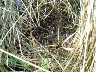
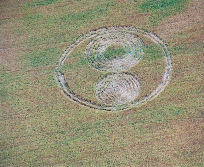
The first crop circle of 2005 here in the USA--a 176'-diam. circle--was reported to BLT on June 12th, at Green Mountain, North Carolina. During the investigation of that circle, we learned of another formation, also in Yancey County in the foothills of the Blue Ridge Mountain chain, found by 2 local men clearing a field about a mile away, far back in a "holler" where it would never have been seen had it not been that these men had been asked to clear the land. It appears that this formation probably occurred at about the same time and it was reported to have had two 20 ft.-diam. circles, connected by a pathway--a classic "dumbbell" type. No photos were taken, since the men had not heard about the circle at Green Mt. and had never heard of the crop circle phenomenon, and proceeded to clear the land. In the following week an email to the BLT office alerted us to another formation reported on Ebay--which was said to have occurred on the night of June 22/23rd, also in "western North Carolina," although no precise location was given (photo below). What was most strange about this formation (a 65 ft. +/- center circle with 3 smaller circles around it placed in a triangular configuration) was that it was being reported on Ebay--and that samples of the plants were being offered for SALE. The report also stated that very dramatic light phenomena had been associated with the arrival of the formation, and that the owner's dogs had become extremely agitated. We had never heard of a crop formation being reported this way, much less of anyone trying to SELL the plants. Additionally, the Ebay report stated that there were "burned" areas in the centers of each of the 3 small circles.
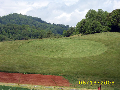
Now a 4th formation (photo below) has been reported in western North
Carolina, this one near Weaverville (just North of Asheville). A
lovely simple circle, it appeared the night of June 22-23rd again in
hay or grasses, and measurements along three diameters show it is not
a perfect circle: 52 ft. 10 inches, by 53 ft. 2 inches, by 57 ft. 3
inches. The lay is primarily clockwise, except for a 3 ft. 9 inch
swath around the outside edge which is laid counter-clockwise.
Additionally, the centre consists of 2-3 ft. wide oval of
clockwise-laid plants. BLT fieldworker Tom Ginther examined the site
on July 3rd and did obtain a small amount of magnetic material which
we will examine with a microscope to see if the tiny 10-40 micron
diameter magnetic spheres are present. John Payne, also reporting on
the circle, states that his cell phone did work within the circle on
July 4, 2005. Payne, an Englishman now living in the States, has
seen a number of British crop circles in the past and felt this one
was quite good in comparison to others he has seen, and is forwarding
on a few
plants he discovered which appear to be "burned" or are otherwise
remarkable, for closer examination.
Several new reports will be posted on the BLT web-site this coming
week, one of which deals directly with this question of blackened and
apparently "burned" plants in crop circles."
Nancy Talbott
BLT Research Team Inc.
|
|
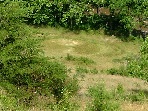
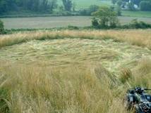
NEW CIRCLE FOUND IN WISCONSIN:
A local southern Wisconsin UFO researcher, Mary Sutherland, reports the
discovery of a very rough-looking double-ringed circle in wheat near
Trevor, Wisconsin on or about June 20th. The formation is approximately
55' in overall diameter and consists of two flattened circles, one with
a large standing centre, surrounded by two very rough-looking rings in
mature winter wheat. It is unclear how long it may have been
there. Ground photos have been supplied by Ms. Sutherland, and we hope
that an aerial and a ground report from field researchers will be
available soon.
Nancy Talbot BLT Research TEAM |
|
Click on Thumbnails to enlarge Images Mary Sutherland Copyright 2005 FIELD REPORT Crop Circle in Trevor, Wisconsin, June 23, 2005
|
|
Image Steve Hardin Copyright 2005
These pictures were made
using a digital camera I have others , this was
on a hillside in Yancey co. North Carolina beside a grave yard ,this is
a mountainous area Anyone would think there was not enough space in this
area for such a thing .
it is aprox. 95 feet across in the photo there is a phone pole
with a transformer on it You can judge from the size of the pole and
transformer about the size of the circle ,
there is a tobacco field below the photo it was said that the people
sitting the Tobacco plants were there until dark and nothing was there
then . some people
seen it early the next morning and said that there were no foot prints
going in or out These photos were taken on Monday June the
13th it was supposed to have been
made on Saturday night June the 11th I was told about this and went and
took some pictures . The local TV station wlos TV
channel 13 is supposed to have done a story on this but I haven�t
seen it . The one that did the story was John Lee If you can tell me
anything about the circle or if you need any more information about this
you can contact me by e-mail I do have more photos there were cattle
Across from this I have pictures of the cattle they are Three different
breeds in one field that was a little different. You have my permission
to use this photo just put Name on it Steve Hardin
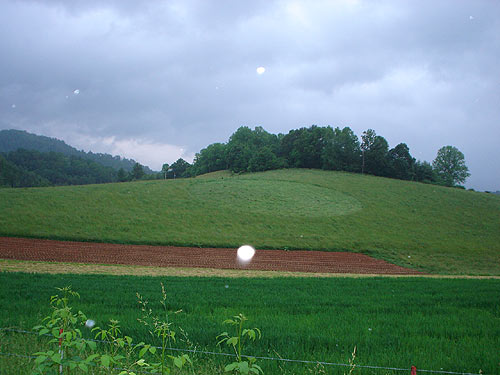
Location: Green Mountain, North Carolina (in Yancey County) - in
field directly opposite the local cemetery
Date Occurred: Saturday night, June 11, 2005
Date Discovered: Sunday morning, June 12, 2005
Crop: 3-1/2' - 4' tall mature hay (ready for cutting)
Dimensions: A perfect 176 ft.-diameter. circle, with a precisely
located central swirl (88' from the centre to edge, measured along 12
radii)
Details: Farmer had been planting tobacco in a nearby section of the field until 8:30 pm Saturday night and, when he left the field, no circle was present. The following day was "Decoration Day" (a day when local residents routinely visit their cemetery to tidy it up and place fresh flowers on the graves); when residents arrived at the cemetery immediately after church services they discovered the circle near the crest of the ridge above the tobacco field. The farmer and first visitors state they observed no tracks or footprints leading into or near the circle, and the lay of the crop was very tight to the ground. There are no houses immediately close to the field and, so far, there are no reports of EM interference, or unusual animal disturbance. This is the first crop circle reported to BLT in this area of the Blue Ridge section of the Appalachian Highlands (Yancey County has the highest average elevation of any county in North Carolina). Because the hay was mature the farmer has now cut the field. On Sunday afternoon (6/12/05) Marc Witson, a local resident, drove by the formation to take some photos at about 7 - 7:30 pm. It was getting close to dusk and some storm clouds were gathering but it was not raining and examination of his photos seems to indicate the flash did not discharge. Multiple small semi-transparent orbs and a few brighter and more opaque orbs appeared on several of his photographs which--if the flash did not discharge--cannot be explained as moisture droplets or dust reflecting the light from the flash close to the lens. One of Marc's photos is enclosed above.. Nancy Talbot BLT Research TEAM UP-DATE ON JUNE 12TH NORTH CAROLINA CIRCLE: While talking with various local residents about the Green Mountain, NC 176'-diameter circle discovered on June 12th, I heard that another formation had been discovered just "over the mountain" two days later. Two men doing "bush hog" work (using tractors to clear a field which had become overgrown) way back in a "holler" (where a now-abandoned white-water rafting facility had once been) discovered two 20'-diameter circles, connected by a small pathway, in a grassy area of the field. This part of the mountains is about as remote as exists here in the U.S. nowadays and is about 1 mile away, as the crow flies, from the circle reported earlier. The men had not heard about the earlier circle and at first thought that the 2 circles were caused by deer bedding down. After learning of the large circle and seeing photos, they realized that what they had found was another crop circle, and they mentioned their discovery to a local relative, who informed me. Since at the time of discovery they had no idea what they were seeing they proceeded to clear the entire field, eradicating the dumbbell-style formation. No photos were taken. A wild cat found on the property in one of the abandoned buildings was observed to behave as if "mesmerized," although it is unknown if the animal's behaviour was in anyway related to the crop circle nearby. |
|
Trevor/Salem, Wisconsin
Vandalism
This formation was reported to the ICCRA by Mary Sutherland of the Burlington UFO and Paranormal Center. She had been notified of its existence by an anonymous tip via email on June 21, 2005. The formation was in wheat, and appeared to be several days old by the time Ms. Sutherland arrived at the field on June 23. ICCRA members Roger Sugden, Ted Robertson, Delsey Knoechelman, Dr. Charles Lietzau, and Jeffrey Wilson arrived on June 25 prepared for a comprehensive investigation. We obtained written permission from the farmer Rob Hawkins of R&C Hawkins Farms, who also helped arrange a photo flight from another local farmer Jeff Thompson, who owns and pilots a plane. Immediately upon seeing the formation from the air, we were suspicious of the crop circle's authenticity:
Photo by Jeffrey Wilson As you can see, the "formation" shows many of the tell-tale signs of being mechanically flattened in strips, leaving a raised strip of not-quite-flattened wheat between each consecutive turn around the circle. While this is not conclusive evidence that the formation was mechanically-made by people, this type of pattern has been shown to be evident in most hoaxed formations to one degree or another. The conclusive evidence would come when we entered the formation on the ground. Within seconds upon entering the formation, we noticed that the exterior edges of the formation exhibited a 'serrated' effect. One typical and notable effect of many hoaxed formations is that they have a 'serrated' edge which is often produced when someone is flattening the plants with a board or a garden roller. As they push the plants over, the plants fall more or less straight ahead - the plants on the edges of the circles then push out straight into the standing crop; as the hoaxer continues around the circle, this flatten-straight, reposition-for-the-curve, flatten-straight, reposition-for-the-curve pattern of motion leaves a serrated edge to the formation because the hoaxer cannot get the plants to fall in a curve as they are being flattened forward. This effect is apparent at the Trevor, WI "formation":
In the photo above, the red arrow points out a good example of not being able to make the plants curve - instead they jut out into the standing crop helping to create a 'serrated' edge. The two red lines identify the regular spacing of the flattening. Photo by Jeffrey Wilson. It did not take us long to locate additional evidence of mechanical hoaxing, including measuring the regular spacing between each strip laid down, broken stalks, crease marks on the stalks, footprints of crushed wheat on the interior edge of the 'ring' and exterior edges of the circles, and then the "smoking gun" of the post holes (discovered by Delsey Knoechelman) which were located in the exact center points needed to 'fix' the circle and ring centers: 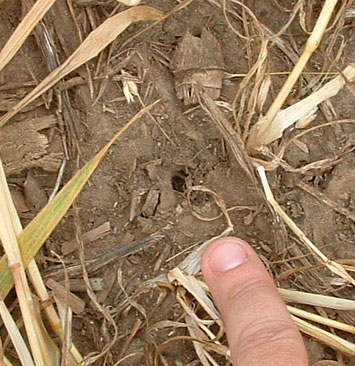  Photos by Delsey Knoechelman Beyond the 'forensic'-investigative evidence which was readily apparent, the ICCRA team took the additional step of running our usual battery of diagnostic tests to compare formation results to controls: L-NEAT - Dr. Charles Lietzau did node elongation measurements to samples collected from both the formation and from 'controls' (from wheat left standing in the field). For the combined samples, the L-NEAT values were negative for both the second and third nodes (no node elongation). No mechanically-made crop circle formation has ever demonstated any statistical node elongation. Many non-mechanically made crop circles exhibit node elongation of 30% or greater. Also, there was no differences in measurements taken of radioactivity, electric fields, magnetic fields, or radio/microwave emission from either the "formation" or outside of it (controls). The ICCRA also measured the "formation" which had been erroneously reported as being approximately 55 feet in diameter but was actually about twice that size - the inner edge of the outside ring was measured at exactly 100 feet in diameter (the outer edge at 112 feet); the standing centre of the larger circle had a radius of approximately 10 feet in all directions; the largest circle had an East-West diameter of 60 feet and a North-South diameter of approximately 58 feet; the smaller circle was ~44' E-W and ~42' N-S. The circles aligned due West (magnetic) - to a telephone pole across the street and due South (magnetic) - to a basketball hoop. Someone took some time in planning out the design and executing the formation with more than one person being involved. The only question left to answer is 'whodunit' - who is responsible for vandalism and property damage?
Two articles about this "formation"
written by the Racine Journal Times have appeared online:
Additional information and photos can
be found online at Mary Sutherland's BUFO website:
Thanks to Mary Sutherland for her
notification and assistance in locating the farmer. Thanks to Rob
Hawkins for his cooperation, and his help in arranging the flight.
Thanks to Jeff Thompson for providing us with a smooth flight.
Western North Carolina crop
circle 'wave'
Four crop circle formations have been
reported now in western North Carolina in the past two weeks:
(1) A single circle near Green
Mountain, in Yancey County, North Carolina first reported on the morning
of June 13:
Photo by Steve Hardin
(2) Yancey County, NC - a second
"dumbbell"-shaped formation was reported by the same landowner but in
a separate, nearby location -- both formations were cut quickly.
(3)
(unknown) [western], NC - a third formation has been reported by Nancy
Talbott of BLT, Inc. She says an
approximately 50� single circle/oval-shaped area has been discovered.
Further details will be made available pending BLT's investigation.
(4) a fourth formation has been
reported in Buncombe County, North Carolina on June 22 as consisting of
a large main circle with three smaller circles evenly-spaced in a
triangle shape: "The circle was about 65 feet across with 3 smaller
circles on the outer edge that if connected would have formed a
triangle. The 3 smaller circles all contained burn marks. Neighbours
within a 10 mile radius have all spotted the lights that we believe
created this circle. We also saw these lights in the hay field the
night before and we discovered the circle the next morning. All of our
animals barked and caused a commotion the night that this happened.
This occured around 11:15 p.m. on June 22, 2005. Our neighbours next
door saw the lights the night of this occurrence and about 4 weeks
prior." Additional details below, and more
to come pending our
upcoming ground investigation.
 Photo by "Margaret"
All the formations in North Carolina
have been reported in hay.
Thanks to Steve
Hardin for reporting the 1st Green Mountain formation to the Crop Circle
Connector
www.cropcircleconnector.com
. Thanks to Nancy Talbott of BLT, Inc.
www.btlresearch.com for
details of the first formation, and for notification of the second and
third formations. Thanks to Margaret for notification and details of
the fourth formation. Here are some additional details:
Tolleson, Arizona RDF plant
analysis update
The ICCRA recieved plant samples from
this formation and conducted an L-NEAT analysis. W.C. Levengood also
recieved a set of samples collected independently from ours. Both the
ICCRA and Levengood's results of the node elongation mesaurements
match. Statistical node elongation was present. A full report will be
available shortly.
Storm damage in Farmland,
Indiana is mis-identified by media as a "crop circle" / RDF
On June 13, Michelle Slaven spotted
some flattened wheat in a field near Farmland, Indiana and reported it
to the local media as a crop circle formation. ICCRA member Roger
Sugden visited the site, and flew over the area which was decimated by a
recent powerful storm. The flattening was caused by the storm. There
was no evidence of this being a 'randomly-downed' formation (RDF). This
story was picked up by the Associated Press and ran in newspapers and on
TV stations across the county - even the Washington Post!
A 'Fairy Ring' is reported by
the media
|