UNITED STATES OF AMERICA CROP CIRCLES OF 2005 11 Formations |
Updated Monday 30th March 2009
Discus North American Crop Circles on the Forum
|
On Nov. 30th Port Arthur News reporter Guiseppe Barranco contacted BLT with the information that a possible crop circle had been found 2-3 days earlier, just off the highway between Port Arthur and Sabine Pass. In a low-lying, wet field of grasses an approximated 30' diameter rough circle was visible from the highway and Barranco reported that it appeared that all of the grasses were flattened in one direction, rather than spiralling around as is typical in many crop circles. Additionally, he observed that a wire fence ran through one side of the circle, with patches of grass swept up against it. From Barranco's photo, below, it is clear that the plants in the flattened area have lost their chlorophyll, suggesting that the circle may have been there for quite awhile. This area near the Gulf has been ravaged by hurricanes and tornados this season and it is possible that this circle may be related to the weather disturbances.
Nancy Talbott
BLT Research Team Inc.
www.bltresearch.com |
|
August
29, 2005 - Belleville, Wayne County, Michigan
We have just received a report of a small, 8 foot diameter "crescent" in corn. ICCRA member Dr. Charles Lietzau has made a preliminary investigation, so photos and additional details will be made soon. The second half of the season is just getting underway here in the USA (we generally have reports into October, and sometimes as late as November)! Jeffrey Wilson Director, ICCRA Independent Crop Circle Researchers� Association [International] (cell) 734-891-2689 |
|
August 21, 2005 - Coles County, Illinois
Two circles in cattle corn were discovered
by the son of the landowner while cutting grass in an adjacent drainage
area. Both circles exhibited a radial lay pattern, which has only been
reported previously a few times. The larger circle was 74' 6" x 78',
and the smaller circle was 22' 10" x 20' 10". The larger circle had a
very slight clockwise spin to it, but also had an outer band of stalks
that alternated as being flattened both clockwise and counterclockwise;
sometimes overlapping, and sometimes diametrically opposed. There was
also a several foot wide flattened line of stalks underneath the main
lay that curved in towards the center. The center of the larger circle
had two bare areas about 5'-8' across. Here is an aerial photo: 
This
formation was measured to be L-NEAT positive for node elongation, and
several of the stalks had unusual damage to nodes such as this:
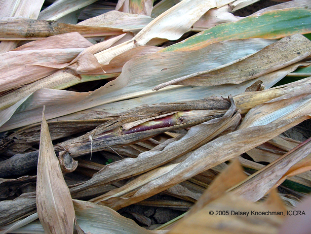
Click on thumbnails to enlarge Analysis of radiation measurements, as well as E-M measurements is ongoing, and further details of this investigation will be made available soon. While several members of the ICCRA conducted their investigation, four different local people contacted us to tell us that around the time of formation, and in the two days following its' discovery, they witnessed a series of unusual lights in the sky in the area of the formation: about 4:30 A.M. the morning after the formation was discovered, two unusually bright white balls of light with beams of light shining towards the ground were spotted in the area towards where the formation was located (although the formation wasn't visible from that location); three different witnesses described seeing brilliant red ("like fire engine red", "brighter than fireworks") BOLs larger than any stars or planets, but smaller than the full moon appear in the sky in the area of the formation - the appearance of the lights caused two of the witnesses to nearly drive off the road.
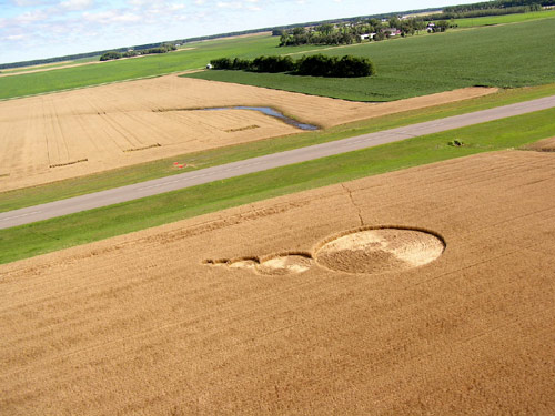
Coles County, Illinois: Found on August 21, in field corn stunted by
drought conditions (about 6' tall), two circles with interesting lay
patterns. These fields are in river-bottom land, near the Embarrass
River.
Aerial photo, above, taken by landowner:
Image JoAnne Scarpellini Copyright 2005
Image JoAnne Scarpellini Copyright 2005
Nancy Talbott
BLT Research Team Inc.
|
|
TWO NEW USA FORMATIONS: NORTH DAKOTA & ILLINOIS
Image Mike Nichols Copyright 2005 Northwood, North Dakota: A lovely 5-circle "thought bubble" in mature wheat, first seen on Friday, August 19th at about 6:30 pm. Power outages are reported by several Northwood residents the previous night, between 2-3 am (8/19/05), as well as at the local grain elevator.Although this is the first formation seen in the immediate area in recent memory, there were formations reported a few years ago in Langdon, ND, and this particular multi-circle design has now been documented in Minnesota and in Washington state in previous years, as well as in the UK many years ago. In this Northwood formation the largest circle is approximately 69' in diameter, the smallest circle 6.5' in diameter, and the lay is counter-clockwise in all circles. Preliminary apical (top node beneath the seed-head) node-length analysis indicates increased lengthening of these top nodes, particularly in the center of the largest circle. No expulsion cavities have yet been found. Bending at the nodes, again particularly in the center of the largest circle, is observed, as is the fact that the centers of the smaller 4 circles are lined up in a straight line, but that the largest circle's center is off-center and angled considerably away from the centers of the other circles.
Image Brad Jensen Copyright 2005 The field does not have tram lines (spraying is done by planes) and the plants are tightly seeded (approx. 5" apart). A local pilot discovered the formation at about 6:30 pm on the 19th and states that no tracks were observed when he first saw the circles. The track going into the field in the aerial photo, below, was made by this pilot as he went into the field to examine the formation. Because the farmer had cut the majority of the standing crop no in-depth plant comparisons can be undertaken, but BLT has taken soil samples for laboratory examination. Detailed measurements, node-length analysis, photos, etc., as well as the lab report, will be posted on the BLT web-site when all the work has been completed.
Image Brad Jensen Copyright 2005 Photos below include the aerial and two close-ups of crop lay and one of the circle centers (aerial photo: Mike Nichols; ground photos: Brad Jensen):
Nancy Talbott
BLT Research Team Inc.
|
|
August 19,
2005 Northwood, Grand Forks County, North Dakota
A series of 5 circles in wheat creating a "thought-bubble" type design was found in the daytime by a pilot flying from the nearby municipal airport. The five circles are all swirled counter-clockwise, with the swirled 'centers' actually being a few feet off from center. The circle sizes are (from largest to smallest): #1 - 68' 8"x 68' 2" ; #2 - 31' 2" x 31' 7"; #3 - 17' 7" x 17' 11"; #4 - 9' 5" x 9' ; #5 - 6' x 6' 5". No unusual plant damage has been reported (no expulsion cavities, node elongation, etc...). Here is an aerial:
Ground photos and a news report can be found at: http://www.grandforks.com/mld/grandforks/news/columnists/rona_johnson/12490474.htm This formation is very similar to one that appeared about 300 miles to the southeast in wheat on August 1, 2000 in Owatonna, Steele County, Minnesota:
|
|
BLT has received the photo below of two long, strange-looking markings in a field, reportedly photographed on August 18th in Northern Colorado. Although these don't appear to be typical crop circles, without better information as to actual location (which aerial photographer Kit Robertson could not provide) we are unable to carry out a field investigation. Our first instinct is that these are mechanically-created impressions (perhaps an experiment of some sort?) but, if anyone can provide location details, we'll try to carry out an on-site inquiry & investigation. Whatever they are, it looks as if a fair amount of energy was expended in creating them. Nancy Talbot UPDATE
Colorado event I recently posted to you has been identified as a "Maze"
in Corn (mazie), constructed as an entertainment for tourists. Egads.
Nancy Talbott
BLT Research Team Inc.
|
|
|
|
A brand new lay pattern--seen for the first time anywhere in the world, so far as we know-- has been documented in a wheat field in Ohio. BLT fieldworkers confirm a clear "Herringbone" inter-lacing or weave throughout the whole formation, if in fact this IS a crop formation. The reason I raise the question is because the Ohio event in a rough SQUARE, without anything circular in sight. A possible UFO is reported on the same day the formation was discovered.
For more photos & field info go to UPDATES page on the BLT web-site, or
directly to: www.bltresearch.com/ohio.htm.
|
|
June 11: Green Mt (Yancey County), North Carolina....176'
diameter. circle
June 11 or 12: Yancey County, N.C......dumbbell (2
20-ft.-diameter. circles connected with short pathway)....NO PHOTO
June 20: Trevor, Wisconsin....dubbed a "fake" by local
investigator
June 22: Western North Carolina (Buncombe County) .... circle
with 3
smaller adjacent in a triangle formation...sm. circles with "burned"
area in centres
June 22: Weaverville, N.C.....53 ft. (+/--) circle
In addition, these are either KNOWN man-made or randomly-downed:
April 26: Riverside, Missouri....MAN-MADE ad
May 17th: Hickory, North Carolina...randomly-downed
June 11: Parker Farmland, Indiana.....randomly-downed
|
|
A person reading my new book remembered
photographing a crop circle she had seen in the Summer of 2005. This
was in Arkansas, USA; more specifically, 2 to 4 miles east of Siloam
Springs, Arkansas.You are free to add the attached photo to your
archive, for what it is |
Recent USA
Crop Circle Activity -
Wisconsin, North Carolina, Arizona, Indiana
by Jeff Wilson


1.jpg)