|
“I looked all
around the pattern in my hay field and there were no
tracks anywhere. But some tall grass was going clockwise and
some was
going counterclockwise. How is that possible?”
- Connie Osborne, Land Owner, Gray, Tennessee
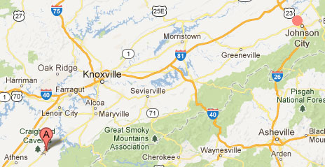
Gray, Tennessee (upper right red circle), is 21 miles northwest
of Johnson City.
Madisonville, Tennessee (lower left red map marker) - where
wheat formations
occurred in 2007 and 2011- is 3.5 hours southwest of Gray, or
about 200 miles.
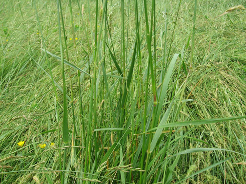
The Gray, Tennessee, crop pattern was reported May 13, 2013,
in 4-foot-tall grasses growing in Connie Osborne's hay field
along
Old Gray Station Road about 21 miles northwest of Johnson City
and about
200 miles northeast of Madisonville, TN (lower left red marker),
where previous
large wheat formations below were reported in the same wheat
field
on May 15, 2007, and May 16, 2011, southwest of Knoxville.
Aerial May 14, 2013 © by Siri Karta.
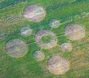
Left: May
15, 2007, Madisonville, Tennessee, wheat pattern
about 170 feet in diameter with crop laid down in
counterclockwise
circles and a triangle in the center circle of standing wheat.
Aerial image © 2007 by Mark Boring, Monroe
County Buzz.
For more information, see 2007
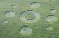
Earthfiles. Right: May
16, 2011,
Madisonville, TN, pattern in same wheat field as the May 15,
2007, formation.
Aerial image © 2011 by Mark Boring, Monroe
County Buzz.
May 31, 2013 Gray, Tennessee - At
8 AM Monday, May 13, 2013, in Gray, Tennessee, 18-year-old Tim
Blumberg went to the mailbox to place a letter his mom wanted
mailed. He was surprised to see a pattern in the nearby hay
field that was not there the day before. The Blumbergs are
neighbors of Connie Osborne, 62, who was born in Carter City,
Tennessee, only twenty-one miles from Gray, where she moved in
1979. Connie works for Host Engineering where she is a solder
tech. She solders printed circuit boards for hard drives. The
lowest part of her 8 1/2 acre farm is a field of eight different
grasses that she grows for another neighbor to harvest as hay
for his animals in exchange for his taking care of her property.
That hay field is about twenty feet lower than her house and is
dotted with large slabs of limestone that are part of the
limestone beneath her hayfield and land.
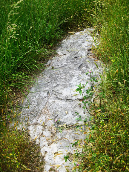
Slab of limestone in Connie Osborne's hay field in Gray,
Tennessee.
The hay field and her property are on limestone with a creek
and spring running through it. Image © 2013 by Roger Sugden.
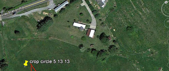
This Google map perspective shows the North designator in far
upper right corner and the
site of the crop pattern at the yellow pointer in lower left.
The land owner is Connie Osborne
and her house, the white rectangle pointed towards Old Gray
Station Road, and her garage,
the nearly vertical other white rectangle, are near a natural
spring that flows from
the South Fork of Cedar Creek over the limestone land.
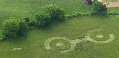
In the
aerial photograph below taken on May 14, 2013, a day after the
crop pattern first emerged overnight, the top tree line is the
creek that runs under Old Gray Station Road in the northwest
along Connie's land. A smaller natural spring branches off the
creek toward her white-roofed house and darker-roofed garage in
lower right of the photo. In the crop pattern that includes
eight species of grasses, the far right partial ring in a
northwesterly direction has a 4-foot-wide curving path to the
small central circle. The middle bar connects the southeast
partial ring that has a narrow 16-inch-wide straight path to
that ring's small central circle. The grasses are laid down
counterclockwise in the northwest ring and clockwise in the
southeast ring. Those opposing flows meet in the center of the
connecting bar.
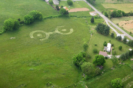
Aerial photographed on May 14, 2013, one day after the pattern
was first
seen at 8 AM by neighbor Tim Blumberg. Image © 2013 by Siri
Karta.
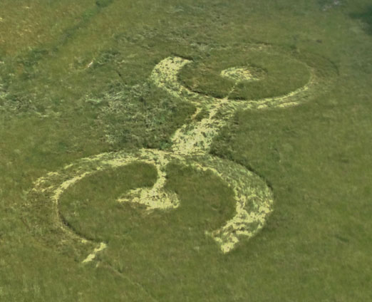
Helicopter aerial of the hay field pattern was on May 21, 2013,
by Connie Osborne's son,
David Jones, nine days after the formation was first reported on
May 13th. The chalky
areas of the downed grasses might be caused by reflective
limestone dust. Another
explanation from Jeff Wilson, Director of the ICCRA points out:
“I believe that the
difference in the colors or reflectivity in this photo is due to
the way in which
the grasses are recovering. The flatter grasses reflect more
light and appear brighter.
The rest of the grass is starting to stand back up and is less
reflective.” The top ring
with narrow straight path to its small central circle is in a
southeasterly direction connected
by the wide bar to the northwest ring that has a 4-foot-wide
curving path to its small
central circle. The standing grasses are 4-feet-tall. The
grasses are laid down
counterclockwise in the northwest ring and clockwise in the
southeast ring,
flowing into the connecting bar where the opposite flowing
grasses
meet at the middle. Aerial image © by David Jones.
I talked with
Connie Osborne on May 27, 2013, about her coming home from work
on May 13th, seeing the big downed area in her hay field and
wondering who entered and damaged it. Connie stressed that she
walked the entire perimeter of her 8 1/2-acre hay field looking
for car tracks, bicycle tracks, shoe tracks, any tracks - but
she found nothing. Then she told me that a series of odd events
had begun happening in Gray since the night of May 3rd to 4th,
ten days before the large, 208-feet-long by 99-feet-wide pattern
appeared in her grassy field. Four friends called to tell her
about a strange blue light hovering in the night sky. Then on
May 10, 2013, a 50-pound ice ball fell out of the sky into a
field only a mile or so from her hay field, source unknown. Then
the morning of May 13th, the pattern emerged in the tall
grasses. And finally on Saturday, May 25th, her good friend
Robin Wheelock had an unusual encounter with glowing orbs inside
the crop formation.
Interview:
Play MP3 interview.
Connie Osborne, Hay Field Land Owner, Gray, Tennessee: “Friends
of mine - and it's three different ladies from three different
areas - had mentioned they saw this strange blue light. And they
said it was the weirdest thing. And it just like hovered and
just stayed there. And they watched it for a good while and they
did not know what it was.
DID THEY
SAY WHAT COLOR BLUE?
Just a
light blue.
AND NO
SOUND?
No
sound.
THAT WAS
MAY 3RD.
Yes,
ma'am.
May 13, 2013 - Large Pattern
Appears in Connie's Hay Field
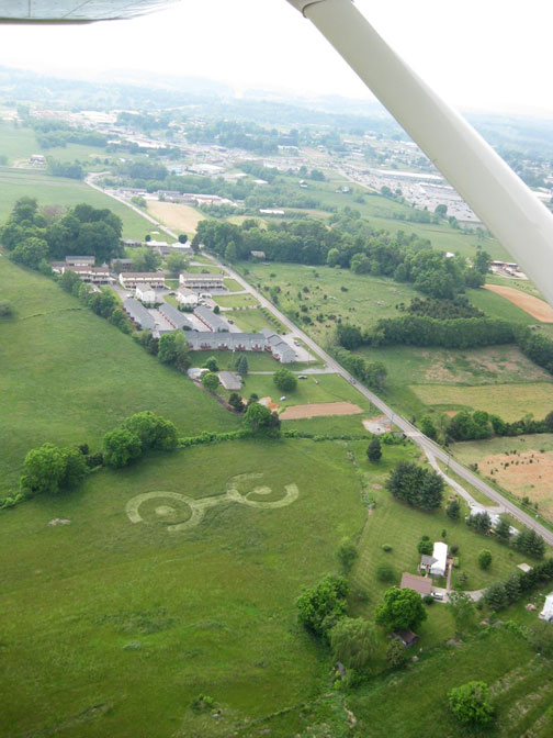
This was the first aerial taken on May 14, 2013, a day after the
pattern appeared
in Connie Osborne's hay field in Gray, Tennessee, near Old Gray
Station Road.
The large 208-feet-long by 99-feet-wide formation is in the
lowest part of the
land on limestone through which the South Fork of Cedar Creek
and
natural spring flow. Image © 2013 by Siri Karta.
TELL ME
HOW THE PATTERN IN YOUR HAY FIELD CAME TO BE DISCOVERED.
Well,
May the 13th was a Monday morning, and I get up to go to work. I
looked down there
(in grassy field), but it just looked like the wind - I
thought maybe the wind had just blown it
(4-foot-tall grasses) down. So I went on to work and the
neighbor's son, Tim Blumberg - he was putting a letter in the
mailbox and he noticed it. Then my next door neighbor, Wayne, he
came out and looked at it, too, and said, ‘What if it's a crop
circle?’
I didn't
realize until I came home and I can see the field as I'm driving
down the road and I wondered what in the world has been over
there in that hay field. I physically walked down there and
could not believe my eyes.
COULD
YOU SEE TRACKS OF ANY KIND - HUMAN OR OTHER - LEADING INTO OR
OUT OF THAT PATTERN?
No,
ma'am. I thought the same thing and I walked - it's about 8 1/2
acres - and I walked the whole property line. I could see my
tracks where I walked down to it, but there were no tracks
anywhere.
IT IS
SITTING THERE RIGHT IN THE MIDDLE OF THE HAY FIELD. THERE ARE NO
TRAMLINES.
No.
AND
THAT'S 4-FOOT-HIGH HAY GRASS, RIGHT?
Oh, yes,
it's up to my waist.
THE
PATTERN IS QUITE INTRICATE.
Yes! One
end it goes counterclockwise and on the other end, it's
clockwise. And in the circles, it's clockwise half way around
and counterclockwise the other way in each circle. And in the
middle, both of the U-shaped parts - the one from the left is
laid down and then the one from the right is laid down over top
of the left. It was just weird how it was done.
IF THERE
IS NO SIGN OF TRACKS ANYWHERE AROUND THE PERIMETER OF THIS
PATTERN IN 4-FOOT-HIGH HAY FIELD GRASS AND YOU ARE LOOKING AT
THAT KIND OF COMPLEX COUNTERCLOCKWISE AND CLOCKWISE PATTERN,
WHAT DO YOU THINK COULD HAVE DONE THIS?
I have
no idea (laughs)! I would love to find out, but I have no idea -
it just appeared unexplained.”
Roger Sugden, ICCRA Researcher,
Investigates May 14-15, 2013
Further
north in Indiana, Roger Sugden, a professional photographer and
artist, is a member of the Independent Crop Circle Researchers'
Association. ICCRA investigates American crop formations and he
has driven hundreds of miles at his own expense to photograph
and study crop patterns that include three in Tennessee that
have emerged in mid-May since 2007. The first two near
Madisonville, were reported on May 14, 2007, and then four years
later on May 16, 2011.
.jpg)
Madisonville, Tennessee (lower left red map marker) is 3.5 hours
southwest
of Gray, Tennessee (upper right red circle), or about 200 miles.
Now this
month of May 2013, in the early morning of Monday, May 13th, at
1:30 AM, Roger was outside looking at the night sky wondering
about Madisonville when two circular clouds connected by a cloud
line caught his attention. Right then Roger wondered if that
cloud pattern was a signal that a crop circle might be in
Madisonville?
So on
Wednesday, May 15th, Roger set off on a 600-mile-journey out of
intuition, got to Madisonville on May 16th, and learned there
was a crop formation, but not in Madisonville. So the next day
on May 17th, Roger drove another 3 1/2 hours northeast to Gray,
Tennessee.
When he
got to Connie's hay field around 2 PM on May 17th, he walked off
the 208-feet-long by 99-feet-wide hay grass pattern and sketched
in his diagram the clockwise and counter-clockwise patterns of
intricately laid down grasses. Roger knew the trip was worth it.
He was inside the beauty of a genuinely mysterious crop
formation so similar to the cloud shape that provoked him to
travel to Tennessee.
Interview:
Roger Sugden, professional photographer and artist and member of
the Independent Crop Circle Researchers' Association (ICCRA),
Fort Wayne, Indiana: “What struck me was some giant
broadleaf plants, sort of like the stems of rhubarb, and they
were absolutely untouched! The grass simply went around them,
flowed right around them.
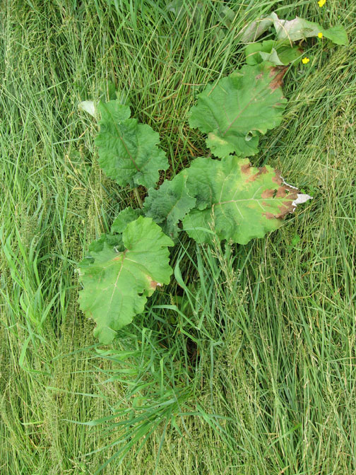
Broadleaf plant inside the Gray crop formation where the grasses
have swirled down
around it, but the big plant is untouched. Similar anomalies
have been found
in English, Italian and other crop formation sites of the world
since
at least the early 1990s. Image on May 17, 2013 © 2013 by Roger
Sugden.
WE'VE
SEEN THAT IN ENGLAND OFTEN GOING BACK TO THE 1990S WHERE
WHATEVER THE ENERGY IS COMES DOWN IN A FIELD MAKING THE CROP
FORMATIONS. IF IT IS A WHEAT FIELD, THE WHEAT IS DOWN OR UP, BUT
THERE CAN BE THISTLES OR BROAD LEAF, AS YOU ARE DESCRIBING, THAT
ARE TOTALLY UNTOUCHED AS IF THIS IS MOLECULE-SPECIFIC ENERGY.
Yes,
that's exactly what it looked like. They were untouched and I
saw multiple sites of that in there (Gray hay field pattern),
including standing grass where (other grass) just flowed down
right around it like it (grass) was water.
Clockwise and Counterclockwise Grass Flows
Inside
the formation, there are different layers and there are
certainly different directions of flow. The northern circle goes
counterclockwise and in the southern circle, it goes clockwise
as just the opposite. The northern circle is counterclockwise
and the southern circle is clockwise on the outer and interior.
Then,
what is fascinating is the middle part that connects the big
circles, almost at the center - the flow is coming in from the
circles, coming in from one circle and stops at the center. Then
it comes in from the other circle and stops at the center where
this solid bar section is.
Grass in Square Pattern
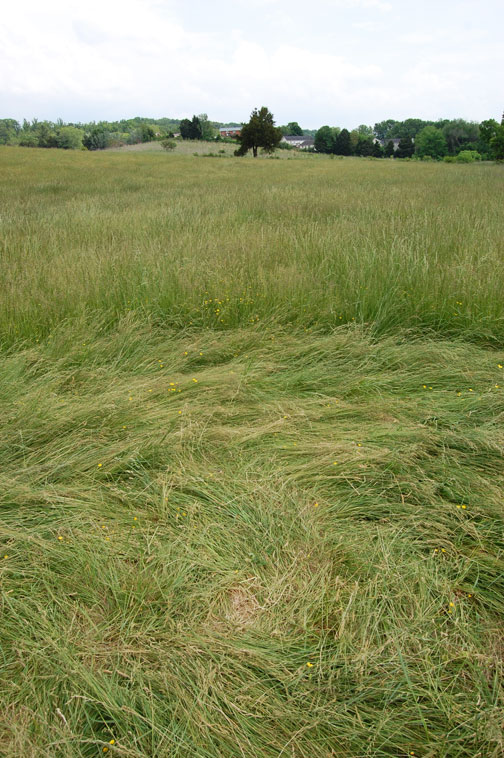
4-foot-tall grasses laid down in a squarish pattern surrounded
by a
herringbone pattern. Image on May 17, 2013 © 2013 by Roger
Sugden.
Herringbone “weave” throughout the Gray, Tennessee, hay field
first found
at 8 AM on Monday, May 13, 2013, in Connie Osborne's field of
grasses where
no pattern had been the day before. May 17, 2013 image © 2013 by
Roger Sugden.
And
there is a little square on the inside of the circular flow. The
flow comes down on one side, goes across, comes at the other
side and makes a nice little square flow and inside that square,
about 6 or 8 feet square, it goes a different direction that is
the flow of the outer circle!
FOUR
90-DEGREE TURNS IN THE 4-FOOT-TALL GRASS?
Yes,
that's exactly what it is. It's quite impressive.
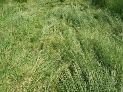
Grasses flowing on ground around untouched standing grasses,
a phenomenon of crop formations in the world since at least the
early 1990s
described as “compartmentalized energies” that can preserve
standing plants
while other surrounding plants are put down to flow like water
around
standing plants. May 17, 2013 image © by Roger Sugden.
THIS IS
A FORMATION THAT FROM YOUR EXPERIENCE COULD NOT HAVE BEEN MADE
BY HUMANS?
From
what I've seen, I don't think it could just because if someone
would come in here and just make this with a board, these giant
broadleaf plants would be crushed, absolutely crushed. They are
untouched. And I saw multiple sites of that in there, including
standing grass where it flowed right around the broadleaf in
multiple areas, not just one.
There
are people who want to do testing on this. I've got soil samples
and plant samples that are going to be tested. But from what
I've seen, I don't see how anybody could make this.
WHAT IS
THE INTELLIGENCE BEHIND THE CREATION OF CROP FORMATIONS?
Oh,
that's a $64,000 question! I think it's an unknown, but I
believe that our consciousness - we're all connected with
everything! And whatever energies there are, whether come from
ancient mound sites or from our own selves - we're connected
with it.”
Mysterious Orbs in Gray Grass Formation
After
Roger spent a couple of days studying the intricate Gray,
Tennessee, grass pattern, he returned to Indiana with samples
for ICCRA to test. But unusual energies persisted in Connie
Osborne's hay field. Her good friend, Robin Wheelock, who was
born and raised in Gray, took some North Carolina researchers
into the hay pattern on May 25th. Robin was standing in one of
the circles while they were videotaping when what happened next
still gives Robin goose bumps.
Interview:
Robin Wheelock, long-time resident of Gray, Tennessee, and
author of © From
Death Row to Freedom: “We went down to
the crop circle, the guy (Rick from NC) was filming it on video.
There was one area in the crop circle where we could stand and
white orbs would come around.
SO YOU
MEAN WITH YOUR OWN EYES ...?
On the
camera. You could not see them with the naked eye.
WERE
THEY MOVING IN THE VIDEOTAPE?
Yes.
ABOUT
HOW BIG WERE THEY SAY IN RELATIONSHIP TO A PING PONG BALL?
He
(cameraman) said whenever I got out there, that there was three
of them (white orbs) that came. And one was sitting on top of my
head. And then I had one on each shoulder. The one on top of my
head was about the same size as my head. [ Video frames showing
the glowing orbs around Robin Wheelock will hopefully be added
to this Earthfiles report in the first week of June 2013. ]
YOU SAW
THIS WITH YOUR OWN EYES ON THE VIDEOTAPE?
Yes. The
one orb that was on top of my head came down and set over my
heart for a little bit and then it's like it scanned all the way
down my body, all the way down to the ground. And then just took
off.
YOU WERE
NOT AWARE OF ANY OF THAT AT THE TIME?
Just the
chill bumps on my arms. (laughs)
YOU WERE
AWARE OF SOMETHING AFFECTING YOUR SKIN?
Yes.
BUT YOU
DIDN'T KNOW WHAT IT WAS UNTIL HE (cameraman) NOTIFIED YOU TO
LOOK AT THE VIDEOTAPE?
After I
came back up to the camera, I'd see it. After the three orbs and
me, it's like the camera went dead. There were squiggly lines in
it and the camera went dead and there was no audio.
SO THAT
WAS TWELVE DAYS AFTER THE GRASS PATTERN WAS FOUND. EXPLAIN AGAIN
WHAT YOU WERE FEELING PHYSICALLY?
There
were chill bumps on my arms and my skin. I mean the hair on my
arms was standing up because of the chill bumps.
DID RICK
BEHIND THE CAMERA SAY, ‘DO YOU SEE ANYTHING AROUND YOU’?
Yeah, he
was asking me that and I told him, ‘'I'm not seeing anything.’
And he said, 'Well, you've got three orbs on you.'
Then he
started telling me where they were on me, but I already had the
chill bumps. (laughs)
WHILE
YOU WERE STANDING THERE AND YOU WERE FEELING THESE GOOSE BUMPS
ON YOUR ARMS, HE WAS TELLING YOU THAT YOU HAD THREE GLOWING ORBS
AROUND YOU THAT YOU COULD NOT SEE, BUT YOU WERE FEELING THOSE
GOOSE BUMPS ON YOUR ARMS. DO YOU REMEMBER HAVING THOUGHT VOICES
IN YOUR MIND? OR IMAGES RUNNING THROUGH YOUR MIND? OR ANYTHING
THAT MIGHT HAVE BEEN COMMUNICATION FROM THOSE GLOWING ORBS?
I have a
heart problem, OK. I have a leaking valve and it causes my heart
to get out of rhythm. I had gone on Friday and had an echo
cardiogram done. And then this happened on Saturday (May 25,
2013) where the orb set on my heart. The thought that was
running through my mind is - maybe it's healing my heart?
(laughs) Or scanning for the problem? Or knows there's a
problem? I have a peaceful, calming feeling.
AFTER
THIS GLOWING ORB SETTLED OVER YOUR HEART FOR AWHILE, DID YOU
FEEL ANY DIFFERENCE IN THE WAY YOU FELT?
Heart-wise, not until the next day when my heart had gone back
into rhythm. I felt very drained of energy.
WHAT
GOES THROUGH YOUR MIND ABOUT WHAT THEY ARE?
I really
don't know.”
The natural spring that runs near Connie Osborne's home
has been where many fossils and ancient implements such as a
stone ax have been found that has been dated back to the
Woodland period around 1,000 B. C. to about 1500 A. D. - a
2500-year period of time that also includes the mysterious
Hopewell intelligence that built thousands of earth mounds
throughout the Midwest with a central focus in Ohio and going
south into Tennessee. The Gray Fossil Site Museum is full of
artifacts. In England, crop formations have also focused on
ancient stone circle and mound sites always provoking the
question: is the intelligence behind the global crop formation
phenomenon knowledgeable about Earth's past, present and future?
If so, what do the modern day crop formations link to in the
flow of time that persists in the plant skin of Earth?
More Information:
For further reports about crop circles
and American mounds, please see Earthfiles Archive from which
some reports are listed below:
• 11/07/2012 — Crop Circle Schematic of Photon Wave-Particle
Duality?
• 10/30/2012 — Part 2: High Strangeness in 43-Circle-Corn
Pattern Near Ancient Mounds of Chillicothe, Ohio
• 10/29/2012 — Updated Part 1: High Strangeness in
43-Circle-Corn Pattern Near Ancient Mounds of Chillicothe,
Ohio
• 10/02/2012 — Crop Circle in Tlapanaloya, Tequixquiac,
Mexico
• 08/31/2012 — Two 2012 U. K. Crop Formations of High
Strangeness
• 06/08/2007 — Part 3: U. S. Crop Formations, Wheat
Pictogram in Madisonville, TN
• 08/28/2006 — Part 2: Five Circle Pattern in Geneseo,
Illinois, Soybeans
• 07/23/2005 — Mystery of Six Grass Circle Formations in
North Carolina
• 10/17/2004 — American Crop Formations: 1880-2004
• 09/17/2004 — Updated: Part 1 - High Strangeness in
Canadian Cattle Corn
• 09/10/2004 — Update on Miamisburg, Ohio, Corn Pictogram -
Balls of Light?
• 09/05/2004 — Part 2 - Hillsboro, Ohio Corn Plant Anomalies
• 09/04/2004 — Hillsboro, Ohio Corn Formation - High
Strangeness in Soil and Plants
• 09/02/2004 — Updated Photos: Big, Impressive New Corn
Formation in Miamisburg, Ohio
• 08/09/2004 — Pictograms in Poland
• 07/15/2004 — Updated: Part 1-Beyond Hillsboro, Ohio, More
Corn Down in New Milford, Connecticut
• 07/06/2004 — Mysteriously Downed Oat Plants in Eagle
Grove, Iowa, and Downed Corn in Hillsboro, Ohio
• 10/17/2003 — 2003 "UFO Flap" in Ohio
• 09/17/2004 — Updated: Part 1 - High Strangeness in
Canadian Cattle Corn
• 06/08/2007 — Part 3: U. S. Crop Formations, Wheat
Pictogram in Madisonville, Tennessee
• 08/28/2006 — Part 2: Five Circle Pattern in Geneseo,
Illinois, Soybeans
• 07/23/2005 — Mystery of Six Grass Circle Formations in
North Carolina
• 10/17/2004 — American Crop Formations: 1880-2004
• 09/22/2004 — Miamisburg and Serpent Mound, Ohio Crop
Formations: Geometries Compared
• 11/01/2003 — Another Soybean Formation in Ohio
• 10/10/2003 — Updated - Ohio Hunter's "Deer Camera"
Photographs Mysterious Glowing Disk
• 10/05/2003 — Part 3 - Paint Creek Island, Ohio Crop
Formation Photographs
• 10/03/2003 — Part 2 - Military Interest in Serpent Mound
and Seip Mound Formations?
• 10/02/2003 — Part 1 - Another Soybean Formation Near Seip
Mound in Ohio
• 09/12/2003 — Second Soybean Crop Formation in Ohio is
Manmade. Special USAF Investigation Unit Involved?
• 10/01/2002 — Part 2 - September 2002 Maize Circles Update:
Canada
Websites:
Gray, Tennessee Fossil Museum: http://www.etsu.edu/naturalhistorymuseum/
Woodland Period: http://en.wikipedia.org/wiki/Woodland_period
Archaeological Institute of America, Hopewell:
http://www.archaeology.org/online/features/hopewell/who_were_hopewell.html
Hopewell Indian Mounds, Chillicothe, Ohio:
http://www.touring-ohio.com/southwest/chillicothe/hopewell-indian-mounds.html
Independent Crop Circle Research Assoc. (ICCRA): http://www.iccra.org/
Silent Circle 2012 Crop Circle Reports: http://www.silentcircle.co.uk/cropcircles2012.html
English
Crop Circles, Current and Archived: http://www.cropcircleconnector.com
Lucy
Pringle: http://www.lucypringle.co.uk
Andreas
Mueller, Germany: http://www.kornkreise-forschung.de/
(Cropcirclescience.org)
American
Crop Circles, ICCRA: http://www.cropcirclenews.com/
“Isaac”
and CARET Document: http://isaaccaret.fortunecity.com/
Canadian
Crop Circles, CCCRN: http://www.cccrn.ca/
Dutch
Crop Circles, DCCA: http://www.dcca.nl
Italian Crop Circles: http://www.zimbio.com/Crop+Circles/articles/OtTQ69cg6RV/Italian
+Crop+Circles+2010+Season
Poland
Crop Circles: http://www.ufocasebook.com/ccphenomenapoland.html
http://www.cropcircleresearch.com
http://www.x-cosmos.it
http://www.bertjanssen.nl |


