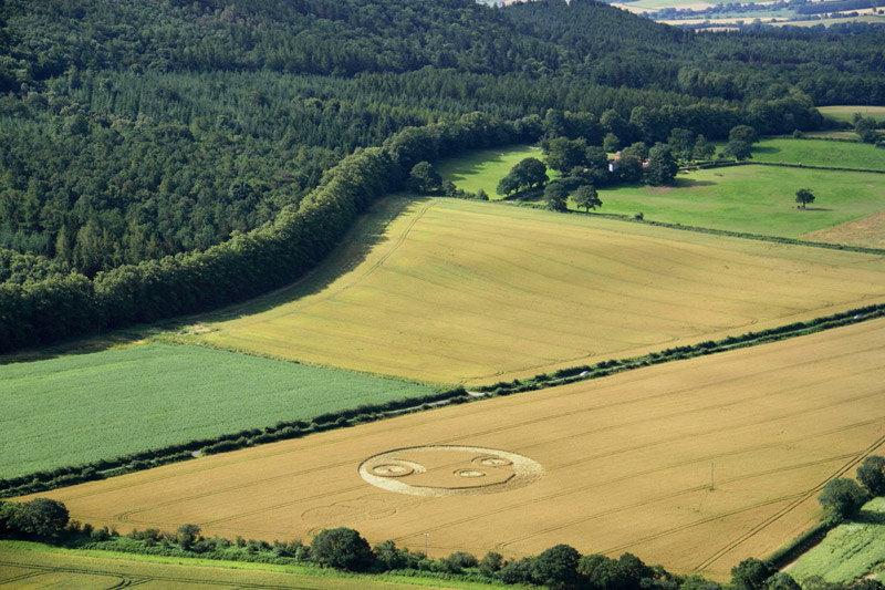
A view of Saturn, Spica and Mars as drawn in crops at The Wrekin on
July 21, 2012 was not exactly from Earth, for the night sky of
August 5, 2012, but rather from above Earth�s north pole by
approximately 20 Earth-Moon distances
Saturn, Spica and Mars were drawn together as a �triangle� in news
releases by NASA over the past few weeks, as part of a public
relations campaign to promote their Mars Curiosity Rover landing in
Gale Crater on August 5, 2012. NASA told everyone to �look up into
the sky and see a Martian Triangle, while our new spacecraft will be
landing on Mars!� (see
www.space.com or
science.nasa.gov).
Perhaps the citizens of Earth were not the only ones to watch such
dramatic events in space? A similar �Martian Sky Triangle� appeared
in crops at The Wrekin in Shropshire on July 21, 2012. Then on July
24 in Wilbur, Washington, another �sky triangle� was drawn in crops,
halfway around the world from England (see
blog.seattlepi.com or
Geibs 2012 or
www.youtube.com).
Who made those two �sky triangles in crops�, one in Shropshire and
the other in Washington? Could they have been made by visiting
extra-terrestrials, studying us from space, to let us know that they
are watching the Mars Rover too?
If we look closely at that diagram drawn in crops near The Wrekin,
we can see an interesting and unexpected feature. Namely, the
precise locations of Saturn and Mars in Earth�s sky on August 5
(small blue circles shown below) lie slightly above
the locations of those same two planets, as they were drawn
precisely in a field (small red circles below) relative to a nearby
star Spica:
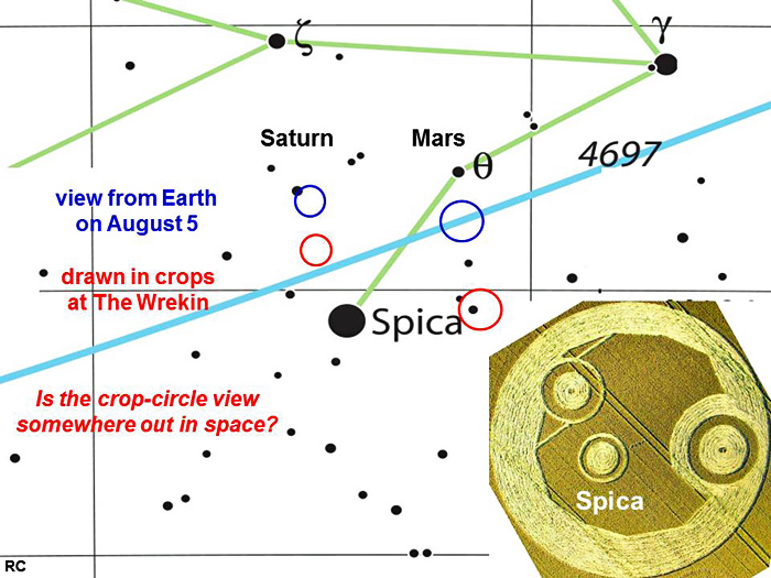
Each horizontal line in this diagram shows values of sky Declination
as 0o, -10o or -20o going top to
bottom. Each vertical line shows values of sky Right Ascension as 14
or 13 hours, going left to right. Thus each planetary symbol for
�Saturn� or �Mars� has moved down in the crop picture
(two red circles) by 1o to 3o of Declination
(for Saturn or Mars respectively), relative to where they would have
been located in Earth�s sky (two blue circles) on August 5, 2012.
The sky coordinates of Saturn, Spica or Mars as seen from Earth on
August 5, 2012 were (RA, Dec) = (13 33, -7 09), (13 25, -11 09) or
(13 10, -7 37) respectively.
If we take the Earth-Mars distance on August 5, 2012 as
approximately 3 x 10**8 km, and consider a -3o
shift of Declination for Mars, relative to where it would
have been observed in Earth�s sky on that same date, then the
tangent of 3o or 0.05 suggests that those crop artists
may be viewing the �sky triangle� out in space, above Earth�s
north pole by 0.05 x (3 x 10**8) = 15 x 10**6 km, or
approximately 20 Earth-Moon distances.
The
Earth-Saturn distance was approximately four times larger than
Earth-Mars on August 5, 2012 as 12 x 10**8 km. Any change of viewing
perspective for Saturn should therefore be one-quarter
that of Mars, due to a shift in location of the observer to
above Earth�s north pole. We measured a change in viewing
perspective for �Saturn� at The Wrekin as perhaps one-half
that of �Mars� (about -1.5o of Declination), yet such
small differences of angle are hard to quantify.
Comparison to an upward shift of Declination by +3o shown
in crops at Santena, Italy on June 17, 2012
At Santena in Italy on June 17, 2012, we saw a crop picture which
showed the Sun and Mercury in Cancer for an identical date of August
5, 2012 (Mars Curiosity Rover landing). Somehow that event is
supposed to lead us into December 21, 2012 (end of the Mayan Long
Count Calendar), as suggested by a nearby �planetary system� in the
same field (see
Santena 2012).
Within that crop picture at Santena, both the Sun and Mercury were
drawn in Cancer with +3o more Declination than would be
seen from Earth. In this case, the visual perspective of those crop
artists would lie approximately 20 Earth-Moon distances below our
south pole (exactly the opposite of before).
The �polar clock� in crops at Manton Drove on June 2, 2012: a clever
joke made by our extra-terrestrial friends?
Thus at The Wrekin (in Shropshire), we saw a change in viewing
perspective on August 5 to far above Earth�s north pole. While in
another case at Santena (in Italy), we saw a change in viewing
perspective on August 5 to far below Earth�s south pole.
On June 2, 2012, we saw a �polar clock� in crops at
Manton Drove (near Marlborough), which again showed a date of
�August 5, Sunday� when Mars Curiosity Rover landed. It also
suggested the Declination of our Sun in Earth�s sky on August 5 as
16 degrees, 45 minutes and 53 seconds (see
chalk pit).
A good joke, is it not? Showing us a �polar clock� in crops, while
they are studying Earth from a nearby perspective above (or below)
our north (or south) poles! Yet very few humans living on Earth
today seem to understand. We react to the star people with
irrational fear. Some humans imagined, for example, that �August 4�
(an inaccurate reading of �August 5�) would be a day of disaster,
perhaps at the Olympics?
After The Wrekin on July 21, we saw three more beautiful crop
pictures at Windmill Hill on July 25, Etchilhampton on July 28, or
Owslebury on July 29. All three of those �counted down� to August 5
(Mars Rover landing) with symbols showing �10-8-6 days� before a
�day of communication�, while using nearby telephone poles to
symbolize long-distance communication between Earth scientists and
their space probe.
A fourth beautiful image of �Mars Science Laboratory� and its
landing site in Gale Crater appeared in crops close to Milk Hill on
the morning of August 5, just before Curiosity Rover landed. No, we
just don�t get it. When will Earth humans wake up and begin to
understand?
Red
Collie
(Dr. Horace R. Drew)