Old Sarum, nr Salisbury, Wiltshire. Reported 5th May.

Map Ref: 

This Page has been accessed
Hit Counter


Updated Monday 17th January 2011


AERIAL SHOTS GROUND SHOTS DIAGRAMS FIELD REPORTS COMMENTS ARTICLES
10/05/10 10/05/10 09/05/10 09/05/10 21/06/2010 17/01/11


We have just heard the news that the Farmer is allowing people into the formation with an entrance of £5 per person. Thank you to Michael Glickman for this information.


Herewith the first crop circle of 2010. It is in oil seed rape and measures approx: 180 foot diameter.  It is a circle containing six arcs intercepted by a small circle surrounded by a larger circle. A lozenge shape lies alongside the sixth arc with seven circles lying in an arc below.  It lies below the ancient Hill Fort Old Sarum in Hampshire.  Sadly due to the fact that it lies in Boscombe Military Air space it is also directly below the helicopter low flight approach zone, the images were taken from 2000 feet and also the crop is not yet in full bloom so the imprint is poor. 

Lucy Pringle


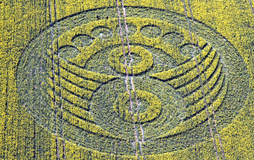
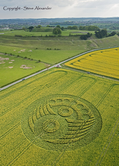
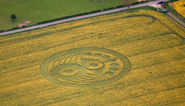
The first week in May we witness the first English Crop Circle in southern Wiltshire. The area around Old Sarum is certainly not an active part of the countryside for the phenomenon. In fact it has only witnessed a few events of the last two decades, which makes this ‘Curtain Opener’ to the 2010 season quite a surprise. Many of the researchers and followers of the Connector were probably expecting the Avebury area to ‘take the prize’ for the first official Crop Circle in 2010.  Perhaps this is the start of a migration for the Circle makers?   Only time will tell!

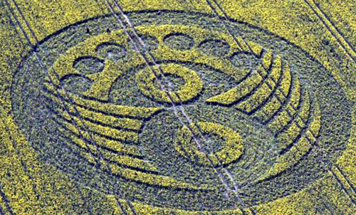
The last time a crop circle appeared close to Old Sarum was 5th June 1992, 1st August 2006 and 6th August 1998

UPDATE:

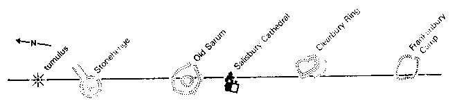
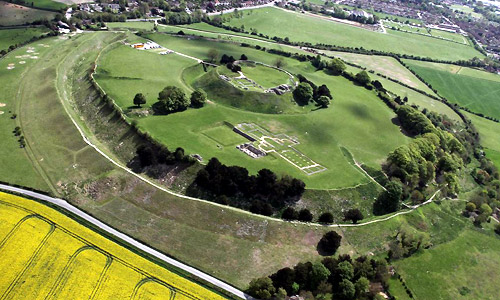
On further investigation, it would appear the positioning of the crop circle in relation to Old Sarum, actually lies on the direct path of a very well know Ley Line which has an alignment with Stonehenge, and cuts the nearside edge of the inner banks of the fortified encampment of Old Sarum. This Ley Line then straight through Salisbury Cathedral itself, and the hill forts of Clearbury Rings and then Frankenbury Camp in Hampshire.  

This clearly indicates that the positioning of Crop Circles could indeed be connected with Ley Lines, which are aligned to well known Ancient Sites. Are we being shown a doorway to ancient knowledge? Will we find the key in 2010?

Stuart Dike


Images John Montgomery Copyright 2010


Image Lucy Pringle Copyright 2010


Image Steve Alexander Copyright 2010


Image Lucy Pringle Copyright 2010


Image Olivier Morel Copyright 2010


AERIAL SHOTS GROUND SHOTS DIAGRAMS FIELD REPORTS COMMENTS ARTICLES
09/05/10 09/09/10 09/05/10 09/09/10 09/05/10 00/00/10


BACK

  
Mark Fussell & Stuart Dike