|
Interpretation
of the Crop Circle Appeared at Clifton, nr Brighouse, West Yorkshire.
Reported 12th July.
The appearance
of this crop circle has brought some troubles to the researchers. It has
been a few days but still no aerial images are available. It’s because
nobody flies that far up north to the location where the circle is laid.
Therefore, to date we only have some ground shots and the computer
diagram courtesy of Psycho Clown. Without holistic images, basically
speaking, it will not be possible to decode a formation. However, thanks
to the ground observation of Psycho Clown, we are able to see the
complete formation on a computer diagram. Since there is no aerial image
to refer to, we can not judge the correctness of this diagram. However,
based on my experience, this diagram is pretty much close to the
original formation and can be used for decryption. So now let’s decode
this diagram.
This formation
is actually depicting the transformation of energy on the earth from
another perspective as discussed in the interpretation of last crop
circles.
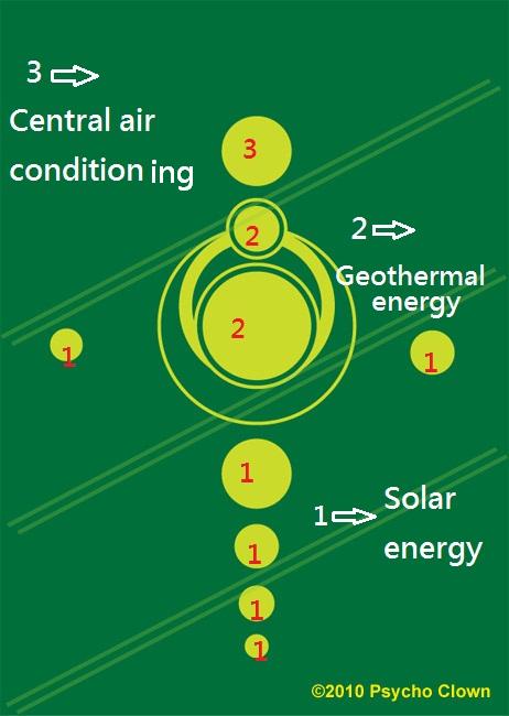
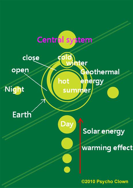
The
primary energy source, solar energy, in this current civilization has
provided mankind with the energy needed for civilization progression
based on the system of alternating day and night. However, warming
effect still continues to worsen over thousands of years. Until the near
future, when it comes to the point of transit to the next civilization,
geothermal energy will replace the sun and become the next primary
energy source. During the sprouting period of the next civilization,
geothermal energy will also provide mankind with the energy to progress
the civilization based on the circulation of summer (geothermal tap open
for one month) and winter (geothermal tap closed for one month). At the
end of the sprouting period, such energy supply system will be
insufficient. Hence, the central air conditioning system will be created
and advance the energy supply mode to an era of consistent temperature.
Human civilization will reach the peak at that time. This formation
explains the evolution of energy over millenniums in three stages;
however, the geothermal energy of the 2nd stage, the system
of alternating summer and winter, is emphasized as key point. That is
why the circles representing the 2nd stage are bigger.
But
there is one particular point which puzzles me. The operation of the
geothermal energy of the 2nd stage has been mentioned in the
last crop circles and why bothers to repeat again here? And the location
is not easily accessed so we can not have complete aerial images to
view. I personally don’t think it is the style of circle makers and
there must be a reason for doing so. Usually the reason has a great
connection with the place where the circle appears. From the viewpoint
of UK, I am a foreigner. I have very little knowledge of the geography
in UK so I can only speculate from the geographical name. The name
Brighouse (or "Bridge House") originates from a building on (or close
to) the bridge over the River Calder. Passage is only allowed when the
gate of the control point is opened, otherwise, no passage is allowed if
the gate is closed. Does it imply the geothermal supply system in the
future? The tap of the geothermal energy will be open for one month and
closed for another month. Or does the crop circle suggest that Yorkshire
is the hub center to switch on and off the tap of geothermal energy?
This is worthy of further investigation.
The original
article is written in Chinese by Crop Circle Decoder: H.K.D.
Copyright 2010
Translator: Lisa
C. Kuo
PS: If you are
interested in the decryption of other circles from us, please check the
article pages of each circle on Crop Circle Connector or you can find us
on Facebook:
http://www.facebook.com/pages/CROP-CIRCLES-DECLASSIFIED/131389306878901 |
