|
|
|
Yarnbury Castle, nr Winterbourne Stoke,
Wiltshire. Reported 16th May.
Map Ref: APPROX
This Page
has been accessed

Updated Wednesday 7th April 2011 |
|
|
Finding the Key.
When I first heard of this new event at
Yarnbury Castle, I was immediately transported back to the early
years of Crop Circling, 1991 to be exact! I was only 22 then,
and could remember in my ‘giddy excitement’ driving down to this
encampment to search for what was the very first formation to
appear in that famous year. Unfortunately I was unlucky in
finding this event, very much like a number of researchers for
this year’s formation.
They say, History can repeat itself, well
obviously this was the third event in 2010, but it was also
positioned in the exact same field as the
1991 event, and in the
same crop. Back then it was a long Dumbbell design, very
simplistic compared with what was to come in later in that year.
Its very hard to spot formations in this
area, the A303 makes its quite dangerous in fact, with traffic
travelling past at 70 miles an hour, its rather disconcerting.
However this area is steeped in history, with the early
settlement positioned across from the formation, and with many
other ancient features like Tumuli, and Enclosures. When you
stood inside this formation, it wasn’t like standing on well
known soil of the area around Avebury. This was something
different, something more tangible, mysterious, and silent.
I have been noticing this year, how the first
formations have been fascinatingly connected to each other
regarding their alignment. We discussed how the Old Sarum
formation had a direct relationship with the Stonehenge design,
positioned rather carefully on the edge of an important Ley
Line, connecting the two sites.
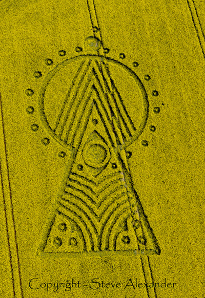
It would appear that the Yarnbury Castle
design, also has a connection with the other two. Although not a
true Triangle, the three formations do create a triangular
pattern across the landscape. What is also intriguing is that
there is also an alignment (or possible Ley Line) connecting Old
Sarum with Yarnbury. This I’m sure is a distinct possibility, as
many ancient settlements have an alignment relationship.
Between Old Sarum and Yarnbury Castle, is Stapleford, a small
village along the River Till. Here there once stood a medieval
Castle with its Earthworks still intact. It resides on the flood
plain of the River Till, and is aligned directly with the other
two ancient sites.
Why are we being shown this so soon within
the season of 2010? Perhaps we are drawing closer to
understanding the behaviour of the phenomenon and its strong
connections with the past? Was it just a strange coincidence
that I mentioned about finding the Key to unlock the
phenomenon’s secrets in 2010. This formation at Yarnbury has an
uncanny resemblance to a ‘Keyhole’. Perhaps the key is to
understand ourselves within this mystery and how we interact
with the phenomenon, raising our awareness to potential truths.
Stuart Dike
|

|
This new formation
at Yarnbury Castle has some rather fascinating aspects to the
design. Certainly a strong connection to Masonic history. On the
ground the formation wasn't neat. A lot of breakage, however I have
always stated that the phenomenon is not always as
perfect as people suggest.
Stuart
Dike |

Images Steve
Alexander
Copyright 2010
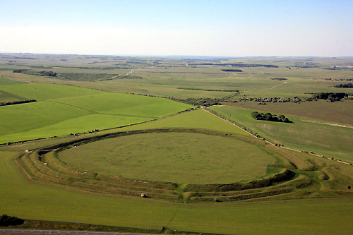
Drive past Stonehenge on the A303 towards Winterbourne Stoke.
Approx 3 miles along this road is Yarnbury castle on your
right. Park in the lay-by opposite - formation is in the field
by lay-by directly behind the trees. It is in Oil Seed rape.
Julian Gibsone |


|
Images Lucy Pringle
Copyright 2010
|
Location: |
Yarnbury Castle, nr Winterbourne Stoke,
Wiltshire. Reported 16th May. |
| Map: |
APPROX MAP |
| Crop: |
? |
| Description: |
? |
| Discovery: |
16th May 2010 |
| Name: |
Busty Taylor |
| Status: |
Waiting for aerial photos |
|
|

BACK |

Mark Fussell & Stuart Dike |
|
 |