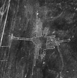
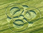
14 June 2009 Barbury Castle Crop-formation is Showing
the Locational Ratio for the SUN at Precise Timings for Y2K and for
2012 December Solstice
© 2009 Michael Lawrence Morton .. All Rights Reserved
This involves encodings in the Archaeo-Sky
Matrix (acronym ASM), a system which I’ve been studying intensively for
more than 18 years as of this writing. Although an introduction to the
ASM would be ideal as a first step here, it would actually be beyond the
scope of this article. I ask the reader to allow me to dive right in
here, if you will, so that I can at least get some of this important
current data on the record .. and so that this information can then be
validated or invalidated as time goes by, via the empirical evidence
which I am assuming will be openly available. I think there is enough
data already, based on my own observation, to warrant some documentation
and explanation. For now, if you will, I invite you to “follow along”
(as much as you can) and to file-away the information and data for
future validation or refutation (or possible correction). Let all
conclusions be supported by self-evident empirical observable data,
aided by the understanding of the observer.
Datasources:
For latitude and longitude (at centers)
of crop-formation locations .. I am using Bert Janssen’s www.cropcirclesandmore.com
database.
For latitude and longitude of all
sky-locations .. I am using the Astrolog 5.40 program (online
freeware with interactive menu) .. sidereal zodiac, with neutral (00 Lat
and 00 Long) viewer-perspective from Earth. This data source uses
Ecliptic orientation .. and the longitudes must be converted to
ALNITAK orientation (West or East) .. with the assumption that
Alnitak’s own (sidereal zodiac) ecliptic longitude is at 29 deg
(sidereal zodiac) TAURUS 56’ 50” or 03’ 10” West of the Cusp of
Gemini/Taurus. Alnitak is the prime meridian marker for all
sky-locations in the ASM .. confirming the 1999 theory of Mary Anne
Weaver. In order to get sky-location raw data to the nearest arc-second,
one must go to the “View” section in the Astrolog 5.40 menu .. and
click-off “show graphics” while clicking-on “print nearest second”. You
will not actually receive a printout on your printer, but you will see a
readout on your screen for nearest arc-second.
14 June 2009 @ Barbury Castle
Given LAT .. 51.49458 degrees Given
LONG .. -1.77678 degrees
The longitude must be converted to
W.Giza .. because the Great Pyramid of Giza is the prime meridian
marker in the ASM on Earth’s surface {Munck; 1991; “The Code, Volume A”,
self-published} .. and the longitude variance between Giza and
Greenwich is assumed as 31 deg 08’ 0.8”.
My assessment .. Longitude encoding
64294.61532 W. Giza = 32(deg) * 54(min) * 37.20753201(sec) .. and
Latitude encoding 59891.43226 North = 51(deg) * 29(min) *
40.49454514(sec)
Grid Point value (intersection point at center) .. (64294.61532 /
59891.43226)
= 1.073519415
I recognize this figure as a particular
ratio .. the ratio of the encoded (ASM) sky-location (against the zodiac
background) for the SUN at two particular moments in time on two
particular dates. These two timings are the Y2K-moment of Greenwich
Midnight at 1999-2000 .. and December Solstice 2012 at 11:11 UT (21
December 2012) which is the exact moment of solstice according to the US
Naval Observatory.
Here is the encoded equation showing
this ratio .. (648 / 603.6220596) = 1.073519415 .. and I will
now explain the details for the SUN’s sky-location at these two precise
timings on these dates. It is also important to note that this precision
involves more than simply the time-of-day on a particular annual
calendar date. This involves the difference caused by Earth’s
precession from one year to the next. The encodings are relevant down to
a fraction of an arc-second.
SUN location @
Y2K-moment .. raw data .. 15 deg SAGITTARIUS (sidereal zodiac) 07’ 21”
to the nearest arc-sec .. which translates to 164 deg 49’ 29” W.Alnitak.
My assessment .. 233280 W.Alnitak = 164(deg) * 49(min) *
29.02936784(sec).
SUN location @ 11:11 UT on 21 December
2012, moment of solstice .. raw data .. 05 deg SAGITTARIUS (sidereal
zodiac) 04’ 26” to the nearest arc-sec .. which translates to 174 deg
52’ 24” W.Alnitak. My assessment .. 217303.9415 W.Alnitak = 174(deg) *
52(min) * 24.01679283(sec).
Because the Sun is always on the
Ecliptic, the ASM encoding for the Sun’s ecliptic latitude is the number
360.
Grid Point location (ASM) value for SUN
@ Y2K-moment .. (233280 / 360) = 648
Grid Point location (ASM) value for SUN
@ solstice-moment on 21 December 2012 .. (217303.9415 / 360) =
603.6220596
Ratio encoding .. (648 / 603.6220596)
= 1.073519415 .. identical to Grid Point value at center of 14 June
2009 Barbury Castle crop-formation.
Counting the Numbers of Days
Speaking of the “Phoenix” symbol (as
relates to this crop-formation) .. the “Phoenix Lights” mass-sighting
incident on 13 March 1997 involved a gigantic UFO that hovered for 4
time-minutes over the intersection of Indian School Road and Seventh
Avenue in downtown Phoenix, Arizona. I have various postings on this, on
the Internet, dating back to just shortly after the incident. If you
count the number of days from 13 March 1997 to 21 December 2012, you
get 5764 including the 4 leap days. I decoded the location of the
“hover-spot” over the just-mentioned intersection as (39478.4176 /
1315.94723) = 30 Grid Point value location, where 39478.4176
North = 33(deg) * 29(min) * 41.25226499(sec) .. and where 1315.947253
W.Giza = 143(deg) * 13(min) * 0.707879103(sec). I recognize the 5764
as representing the ASM figure 5764.166073, which is the original
encased height {Munck, 1991} in regular English inches (including
capstone) for the Great Pyramid of Giza, and is also the north-face
location Grid Point value {Munck, 1991} for the Chephren Pyramid of
Giza.
If you take the ratio of these two
figures pertaining to the ‘Phoenix Lights” incident, you get
(5764.166073 / 30) = 192.1388691 .. and I recognize this as
exactly 10 times the 19.21388691 height {R.Carl, Internet} in regular
English feet for the “King’s Chamber” inside the Great Pyramid of Giza.
And 19.21388691 is also the apparently encoded (ASM) value for
the mean AU distance of planet URANUS {R. Carl; Internet}.
Note .. 192.1388691 = (206.2648063 /
1.073519415) .. where 206.2648063 is the width {M. L. Morton;
Internet} of the King’s Chamber in regular English inches, and is also
apparently encoded in the ASM as 10 Royal Cubits of 1.718873385 regular
English feet per Royal Cubit {M. L. Morton; Internet}.
And .. (206.2648063 / 1.073519415) =
(603.6220596 / 3.141592654) .. using the Pi constant out to 10
digits. You will recall that 603.6220596 is the ASM encoding for
the Sun’s location as of the 11:11 UT moment of solstice on 21 December
2012.
Keep in mind that Thoth is associated
with measurements (and mathematics, of course). Z. Sitchin has made a
very good case (IMO at least) for Thoth being the same historical
person as Quetzalcoatl .. having been “deposed” in Egypt by his
half-brother Ra/Marduk, and having then relocated (circa 3100 BC) to
what is now Mexico (also having a major influence in what is now the US
and also in what is now Central America). And Quetzalcoatl is associated
with these bird symbols pertaining to both the 12 June 2009 Yatesbury
and the 14 June 2009 Barbury Castle formations.
Also .. (206.2648063 / 1.073519415)
= (238.3004375 / 1.240251067) .. where 238.3004375 is the {M. L.
Morton, Internet} Grid Point value center location (ASM) encoding for
the Great Pyramid of Giza .. and where 1.240251067 is the encoding for
the center (Grid Point) location of the well-known “Pi out to 10
digits” crop-formation of 01 June 2008 Barbury Castle.
Center latitude encoding for Great
Pyramid of Giza .. 85788.1575 North = 29(deg) * 58(min) *
51.00366082(sec) .. {M. L. Morton, Internet}. Using the figure 360 for
the ASM prime meridian through the center of the Great Pyramid of Giza {Munck,
1991} .. (85788.1575 / 360) = 238.3004375
Regarding the 01 June 2008 Barbury Castle formation
.. raw data .. LAT 51.48886 and LONG -1.77026 .. and my assessment is
Latitude encoding 29377.88974 North = 51(deg) * 29(min) *
19.86334668(sec) and Longitude encoding 23687.05056 W. Giza = 32(deg)
* 54(min) * 13.70778389(sec). So the (center) intersection is
(29377.88974 / 23687.05056) = 1.240251067
Using Pi out to 10 digits ..
(3.141592654 / 1.240251067) = 2.533029591 .. and this is the exact
ratio of (603.6220596 / 238.3004375). And .. this is also the
exact ratio of (7.957747155 / 3.141592654) .. where 7.957747155
is the {M. L. Morton; Internet} ORION Belt-stars Composite, where the
Grid Point value sky-locations for the 3 ORION Belt-stars form this
equation .. (43.63323131 Alnitak * 31.00627668 Mintaka) / (170.010936
Alnilam) = 7.957747155
Now .. regarding the 15 July 2008 Avebury Manor “Solar System”
crop-formation ..
raw data .. LAT 51.4314 and LONG -1.85696 .. and my assessment is
Latitude encoding 67712.74158 North = 51(deg) * 25(min) *
53.10803261(sec) and Longitude encoding 48858.04898 W. Giza = 32(deg)
* 59(min) * 25.87820391(sec). So the (center) intersection is
(67712.74158 / 48858.04898) = 1.385907605
This crop-formation was obviously
placed in close proximity to Avebury Circle, which is in fact seen
prominently in the background in the photo on the
cropcircleconnector.com website. The (updated to WGS 1984 mapping datum;
R. Carl; Internet) ASM encoding for the center of Avebury Circle is
Latitude encoding 55770.96019 North = 51(deg) * 25(min) *
43.74192956(sec) and Longitude encoding 28800 W. Giza = 32(deg) *
59(min) * 15.25423729(sec) .. and so the intersection is (55770.96019 /
28800) = 1.936491673
Now recall that this formation shows a
layout of the Solar System planets as of 21 December 2012 with the Sun
in the center, of course.
Number of Days from 15 July 2008 to 21
December 2012 is 1620, including the leap day.
[1620 / (1.385907605 * 1.936491673)] = 603.6220596
.. the ASM encoding for the Sun’s location at the 11:11 UT moment of
solstice on 21 December 2012.
(1620 / 1.073519415) = (480.3471728 *
3.141592654) .. where 480.3471728 is the original encased height {Munck;
1991} including capstone, in regular English feet, for the Great Pyramid
of Giza.
(1.936491673 * 1.385907605) /
1.073519415 = 2.5 = (1620 / 648) = (1.240251067 * 2.015720902)
Also
.. please note .. that the figure 1.936491673 is the ratio
of (480.3471728 / 248.0502134) .. where 248.0502134 is the {Munck, 1991}
north-face Grid Point location for the Great Pyramid of Giza ..
where (89298.07683 / 360) = 248.0502134 .. where 89298.07683 North =
29(deg) * 58(min) * 53.09041429(sec)
The 648, you will recall, is the ASM
encoding for the Y2K-moment sky-location of the SUN. Remember
that 1.073519415 = (648 / 603.6220596) .. where the actual equation
for the Sun’s location at the Y2K-moment is (233280 / 360) = 648, as
you will recall from earlier.
The 2.015720902 is the ASM encoding for
the sky-location of the {M. L. Morton, Internet} fixed star PEACOCK
.. which is quite appropriate considering that a peacock is a bird and
that the peacock can symbolize a particular phase in the alchemical
process. Also note that 2.015720902 = (480.3471728 /
238.3004375) which is showing the encoded ratio for (Encased Height in
feet / Center location) of the Great Pyramid of Giza. Here is the
ASM encoding for sky-location of PEACOCK .. W. Alnitak Ecliptic
Longitude encoding 46841.1209 = 150(deg) * 52(min) * 6.005271911(sec)
and S. Ecliptic Latitude encoding 23237.90008 = 36(deg) * 15(min) *
43.03314828(sec) .. and so the intersection is (46841.1209 /
23237.90008) = 2.015720902
If you
multiply the Grid Point values for 01 June 2008 Barbury Castle and 15
July 2008 Avebury Manor crop-formations .. (1.240251067 * 1.385907605)
= 1.718873385 .. you have the exact value for the Royal Cubit
in regular English feet {M. L. Morton; Internet}. And here I ask
you to recall something I mentioned about the “Phoenix Lights” incident.
I mentioned that a gigantic UFO hovered over the intersection of Indian
School Road and Seventh Avenue for 4 time-minutes. As researcher
Klaus Totzek of Germany had originally pointed out to me, 4 time-minutes
is the length of time it takes for Earth to rotate one degree on its
axis. I’ve discovered the ASM encoding for equatorial Earth
circumference to be 24901.19744 statute miles .. and so one
degree of axial rotation would be (24901.19744 / 360) = 69.16999289
statute miles at the equator in the ASM encoding. If you then take the
Grid Point value for that hover-spot over the above-mentioned
intersection .. (30 * 69.16999289) = 2075.099787 statute miles in 30
degrees of Earth’s axial rotation at its equator, which covers 2
time-hours .. which also references the longitude variance between Giza
and Greenwich.
This then
means that one time-hour of axial rotation at Earth’s equator would
encode (2075.099785 / 2) = 1037.549893 statute miles (in the
ASM) for Earth’s equatorial rotation speed in MPH. And now you
can see how the value of the Royal Cubit in regular English feet is
relevant here .. because .. (1037.549893 / 1.718873385) =
603.6220596
Now ..
regarding the 25 August 2008 East Field crop-formation
(a 7-fold design) .. raw data .. LAT 51.3641 and LONG -1.83892
.. my assessment is Latitude encoding 54325.98537 North = 51(deg) *
21(min) * 50.72454283(sec) and Longitude encoding 38880 W. Giza =
32(deg) * 58(min) * 20.94827586(sec) .. and so the intersection is
(54325.98537 / 38880) = 1.397273286
The
Number of Days from 25 August 2008 to 21 December 2012 is 1580,
including the leap day. I recognize that the 1580 is representing the
ASM figure 1580.278857 .. which is confirmed when I notice that
(1.397273286 * 360 * 3.141592654) = 1580.278857
The (360 *
3.141592654) is encoded at the 11:11 UT timing of the solstice moment on
21 December 2012, by an equation showing the sky-locations of the
SUN, planet MARS, and planet VENUS. I’ve already shown the details for the SUN’s location
at this timing. For MARS at this timing .. raw data .. 01 deg CAPRICORN
(sidereal zodiac) 30’ 08” to the nearest arc-sec, and S. Ecliptic 01 deg
09’ 51” to the nearest arc-sec .. my assessment is W. Alnitak 162000 =
148(deg) * 26(min) * 42.0997921(sec) and S. Ecliptic 458.6977616 =
01(deg) * 09(min) * 50.96641795(sec) .. and so the intersection is
(162000 / 458.6977616) = 353.1737313
For VENUS
at this timing .. raw data .. 11 deg SCORPIO (sidereal zodiac) 39’ 38”
to the nearest arc-sec, and N. Ecliptic 01 deg 06’ 28” to the nearest
arc-sec .. my assessment is E. Alnitak 324696.9701 = 161(deg) *
42(min) * 48.01788969(sec) and N. Ecliptic 167.9767419 = 01(deg) *
06(min) * 27.99612365(sec) .. and so the intersection is (324696.9701 /
167.9767419) = 1932.987665
And so ..
(1932.987665 VENUS * 353.1737313 MARS) / (603.6220596 SUN) =
1130.973355 = (360 * 3.141592654) .. all at the same timing ..
11:11 UT, at the moment of solstice on 21 December 2012.
(360 *
3.141592654) also encodes the N. Ecliptic Latitude for the fixed star
REGULUS (Horus) .. where 1130.973355 N. Ecliptic = 27(min) *
41.88790205(sec) .. located very close to the Ecliptic, indeed.
Now ..
please recall the figure 192.1388691 from earlier .. and how this is the
ratio of (5764.166073 / 30) involving the “Phoenix Lights” incident, and
that 192.1388691 = (648 / 3.141592654) / 1.073519415 = (603.6220596
/ 3.141592654) = (238.3004375 / 1.240251067)
Note ..
(360 * 3.141592654) * 192.1388691 = 217303.9415 .. the encoding
for the W. Alnitak Ecliptic Longitude of the SUN at 11:11 UT on 21
December 2012. |