|
FOR VISITING THE CROP
CIRCLES.
|
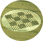
We have seen a small Crop Circle in a field just
outside the Avebury circle 2 days ago on 20 August
2007. The attached file ( see arrow )
will give you an idea of the location of what we
saw. It was difficult to get a good view from the
ground. The crop circle was quite near to the road
but there was no entrance path. The crops was
undisturbed all around.

|
Woodborough, nr Alton Barnes, Wiltshire. Reported 16th August

This Crop Pattern is man made
Image
Philippe Ullens
Copyright 2007
This crop pattern was made for a
promotional video for a Australia band. A member of the
Carson family who owe the land watched them making the
pattern during the day. This is a confirmation that IT
IS Man Made and to avoid any false rumours circulating.
Gyroscope - Snakeskin Music Video in the Crop Pattern

 |
|
Location: |
GREEN STREET-HEREPATH/CLOSE TO AVEBURY
JUNCTION |
| Map: |
|
| Crop: |
BARLEY? |
| Description: |
Close to the road and the metal
barn/buildings-also has a few miniature circles on the perimeter
close top the roadside edge |
| Discovery: |
13TH AUGUST 2007-BUT SAID TO BE AROUND
FOR LAST 10?DAYS |
| Name: |
JOHN LEVINE |
| Status: |
Waiting for picture evidence |
|
Location: |
Between Slough farm (Caerwent) and
railway by A48 at Crick |
| Map: |
348679E 190199N (N51:36:30
W2:44:33) (not sure of OS I used streetmap.co.uk) |
| Crop: |
wheat? (brown) |
| Description: |
2 different possibly large designs |
| Discovery: |
18 July |
| Name: |
Smith |
| Status: |
Waiting for picture evidence
UPDATE #2
Have had another look, although I
couldn't get an ideal view of either field I mentioned, I would
say that there possibly was at least one possible combination of
circles and lines that could have been a formation - but
unfortunately everywhere is a mess as you would be well aware of
with the recent floods. I think If I could get a high enough
view of either there would be no distinguishable feature to make
out. Shame, I've never seen a crop circle yet. I even reported
a circle to you in June which was a man-made advert (west of
Avebury) - to my disappointment.
Smith |
UPDATE #5

Diagram Jay Goldner Copyrighjt 2007
Concerning the cut Bournemouth airport formation on your
rumour page
I tried to reconstruct the design from the harvested ground
- which
might look close to my enclosed sketch.
Jay Goldner
UPDATE #4
I was in the formation on
Monday 6th of august when the crop was already
cut. From the ground it was hard to figure out
if there was so me sort of geometry involved.
But I managed to make a drawing and did a little
measuring by taking big steps. After about 15
minutes I experienced that typical shaky feeling
in my body that tells me there some sort of
radiation energy is involved. Therefore I'm
convinced about its origin. To me the radiation
seems stronger than other formations I visited
here in Wiltshire this season. Besides this
energy aspect I must say that the geometry looks
pretty complex to me to do.

I think it is still
worthwhile for researchers to go out there
because of the strong energy so that it can be
confirmed as real by others as well. After all
it is very unique and a historical thing to find
a (ex) formation that has a tree in the middle!
At the airport I asked around
if people had taken pictures of it with the
standing crop. I was directed to a very
kind helicopter pilot who usually does these
things. So I met him the other day and he and
his colleague unfortunately hadn't taken
pictures of it when it was still intact. But,
and this was incredibly kind, they offered me a
free flight for taking the aerial pictures after
all! So many many thanks to Gary Ellson and
Ollie Pennington for giving this valuable
opportunity. The pictures I show here are done
by Gary Ellson. Talking about spirit, he's not
even bothered about copyrights...
Randell |
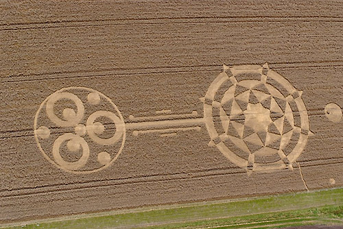
UPDATE #3

Image Randell Copyright 2007
I got something much better
for you right now. The day before yesterday I
had a helicopter flight over the Bournemouth
formation witch I read about at your rumours
section.
Randell |
UPDATE #2
After seeing the entry on the rumours
page for the possible Bournemouth airport circle, I thought
I would check it out on Saturday - as I was down visiting
the area that day.
Frustratingly, I couldn't see an easy way
into the field. There is a high barbed wire fence all the
way around, and what with the recent airport heightened
security I didn't fancy trying to climb in! While I
was there, a big police 4x4 cruised by, so I didn't want to
chance it.
I'm 95% sure there IS a formation in the
field. Outside of the crop impression, the field is
virtually free of wind damage, and I doubt the impression
that is there, would be quite as symmetrical either side of
the tree if it was just due to that.
I managed to get a slightly better photo
than the one shown on your site by holding the camera aloft
on a tripod. It appears to show at the very least a large
flattened outer ring, with a more complex pattern lying
inside. I would estimate the formation to be 200 feet
across, and I think the crop is oats? Its definitely not
barley, and I don't think it is wheat either.
Maybe someone braver than me might hop
into the field for a closer look, failing that you'd think
an aerial image would be easy to obtain given its location?
Andy Cobb
UPDATE
I am in Ringwood today and as I am only
short distance from where this 'rumour' is I thought I would
check it out. from the side of the main road and along the
airport entrance you can just about see it and this is where
the other images were taken however its hard to make
anything out. so I went round the back of the field where
the entrance is and closer to the tree, from there it was
clear that the downed area has very little geometric shape
if any and looks a lot like wind damage to me. There were
also other areas of wind damage in the same field.
I am including a photo of the "formation" from the back of
the field.
Mark (Incanus)
|
|
Location: |
Approx 300m NE of Parkwall Farm (2
miles west of Chepstow?) in the sloped field overlooked by motorway |
| Map: |
350500E 190500N (N51:36:40 W2:42:58) (prob
not OS but I used Streetmap.co.uk) |
| Crop: |
Possible wheat (brown) |
| Description: |
Can't tell as It is hard to view from
ground (other possible circle/s I emailed also hard to see) |
| Discovery: |
15,16th July |
| Name: |
Smith |
| Status: |
Waiting for picture evidence |
|
Location: |
Bournemouth airport |
| Map: |
SZ120973 |
| Crop: |
|
| Description: |
|
| Discovery: |
|
| Name: |
|
| Status: |
Waiting for further confirmation from
anyone in the area |


West Down, Nr Beckhampton, Wiltshire. Reported
19th June.
As in the case with the latest circle
West Down, Nr Beckhampton, Wiltshire. Reported 26th
June. This I reported onto the forum back in May along with
ground photos and a bit of investigating went on. I was
going to report it then as a crop circle but found out it
had been there in fact years and is nothing more than a mown
burial mound.

MATT |
|
Location: |
Yatesbury Field microlite centre on A4
nr Cherhill |
| Map: |
|
| Crop: |
|
| Description: |
The additional circle is in the
central area of Yatesbury 1, 20cms adjacent to one in the main
ring, with a neat compact solid lay like in established green
wheat, clear and fresh.
|
| Discovery: |
|
| Name: |
|
| Status: |
Commissioned crop pattern for the
Charity Scope. The Centre O of the logo is the crop circle design.
 |
|
Location: |
In a paddock opposite the river Thame,
Stadhampton, Oxfordshire. |
| Map: |
SU597986 |
| Crop: |
Grass |
| Description: |
Circle of standing rings. |
| Discovery: |
3/6/07 |
| Name: |
Catherine Huish |
| Status: |
Waiting for picture evidence |
|
Location: |
Behind the Cherry Tree pub, Stambridge,
Rochford, Essex, near Southend Airport. |
| Map: |
|
| Crop: |
in rape |
| Description: |
200ft formation |
| Discovery: |
|
| Name: |
|
| Status: |
Formation is about 6 weeks old. Need a
picture |
|
Location: |
In field off M25 anti clockwise just
before junction 27 (A127) |
| Map: |
|
| Crop: |
Young Wheat |
| Description: |
Figure of Eight |
| Discovery: |
31/5/07 |
| Name: |
Steve kerley |
| Status: |
Waiting for picture confirmation |
|