|
|
CROP CIRCLE RUMOURS 2004 (22 formations) Updated Wednesday 8th September 2004
|
|

Discuss the rumours on the Forum
| Location: |
Garsington(2)Nr,Oxford |
| Map: | SP579014 |
| Crop: | Wheat |
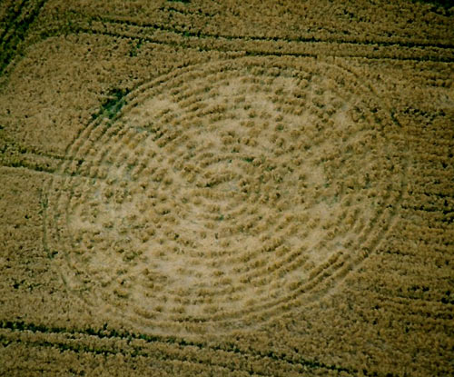
| Description: | Second Serpent/Dragon Pictogram Close By To Previous Event |
| Discovery: |
22 August 2004 |
| Name: | Daniel |
| Status: |
|
Images Annemieke Witteveen Copyright 2004 An experiment by Maurice Osborn to communicate with the crop circle aliens. The crop circle was created near to West Lavington, nr Devizes, Wiltshire. Reported Saturday 14th August. A note from Maurice. "I announced my plans to create a crop formation on August 12, 2004 with a message from humanity in the same format as the disk message in the 2002 Crabwood Farmhouse crop formation. Obviously, my crop formation would be of little interest to anyone if a new formation with a reply does not appear on August 14th or 15th as expected. However, if a response does appear, than these crop formations could be of immense importance for mankind". |
NATIONAL GEOGRAPHIC SHAMED
|
NATIONAL GEOGRAPHIC COMMISSIONED HOAXING AT WEST KENNETT LONG BARROW
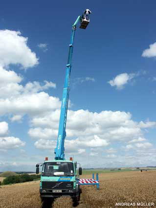
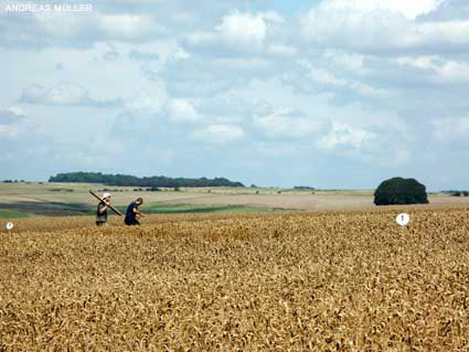
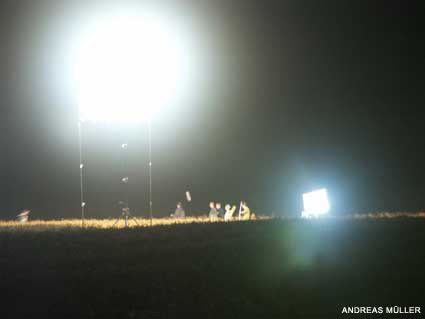
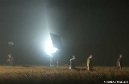
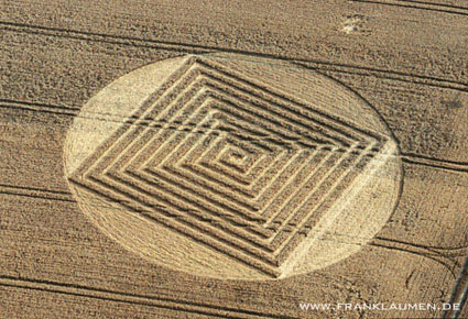
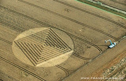
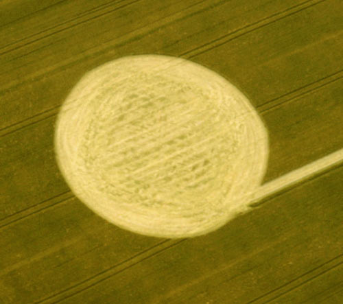
This year�s annual major TV-Crop-Circle-Faking was commissioned by "National Geographic� (...well indeed, there seem to be only very few stations left around the world who had not yet came up with this amazing "new� idea for a show...). They were filming for the first time at night within a field next to the West Kennett Long Barrow that already hosted two formations, showing a local hoaxer making a circle. The scene was well-lit by powerful set-lights. Then again at night, on August 9-10, inside the already present "Sun and Moon� formation just opposite the Long Barrow, now featuring "Team Satan/The Circlemakers� from London stomping around and playing Hide and Seek in the already present formation and once again in the artificially well-lit field (see night-photos). In both nights the set was very well visible because of the lights from the road. This team then returned during the following daytime on August 10, now in a field a bit behind the Long Barrow, where the team of three made a formation � with the farmer being paid � filmed by a time-laps camera up on a crane. This took the three men a total of about 5 hours, beginning around noon and descending the crane back to the ground at 5:00pm. The used tools were the known boards, measure-tape, stick and numbered marking-plates (see daylight-photos). When speaking to the people in charge for the programme, they assured us that "it will be a balanced programme on the phenomenon� - sounds somehow familiar? Asked what such a huge hoaxing-effort has to do with a balanced programme on the phenomenon� the same people became suddenly less telling and slightly angry. At least some of the crew (unofficially) admitted, the programme might be not as much balanced as officially claimed�. Well, maybe this time we are wrong (again) and the programme will be the very best crop circle documentation of all time...But then, why did National Geographic spend that much efforts, time and money on showing that people can flatten crop into geometrical designs, and why did they made parts of it in night time but with artificial light. And why was it - as some of the stuff confirmed - that the London-team was paid while researchers who were also interviewed did (to my present knowledge) not see a penny? Well, as I said, maybe we are wrong� Report Andreas Muller
|
|
NATIONAL GEOGRAPH IC 2004 HOAX -
UPDATE
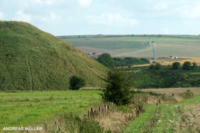
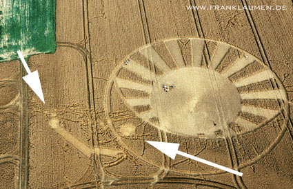
With the support of Frank Laumen's aerial pictures I can now update my previous report on National Geographic TV's commissioned hoax activities at West Kennett Long Barrow this summer. One picture shows the results of "stomping around" in the already present "Sun&Crescent" formation just opposite the Long Barrow. The two others show the final result of the 5 hours daylight hoax by the 3-man-team of "Team Satan/The Circlemakers" that was cut out directly after the work was finished...well, to late for Frank. But again, maybe I am wrong and it will be the best and balanced crop circle documentation ever...maybe;-)
Andreas Muller
Images Frank Laumen Copyright 2004 |
|
We were driving
along a minor road between Fosbury and Oxenwood on Friday
and noticed an unusual formation without apparent regularity in
the field opposite the drive to Fosbury House very close to
the road. The corn was pressed in a North to South
direction. Because of the irregularity I would have
suspected it was wind blown had the corn not been so well laid. I
thought it might be worth a look from an aircraft, even though it
appears relatively unexciting, it was unusual to see corn
laid without apparent design.
If you get the time let me know
what you think as my wife spotted it and it was her first
"circle" before we viewed the more impressive ones from Milk
Hill.
|
| Location: |
off the A23 (left hand side) towards Brighton, possibly 5 -10 miles from Sussex University (Falmer site) - viewable from top floor of bus, but not that easy . |
| Map: | |
| Crop: | Wheat? |
| Description: | double spiral - quite simple - 2 "arms" spiralling out from a central point. |
| Discovery: |
8th August 2004 |
| Name: | Imogen Mitchell |
| Status: | Waiting for picture confirmation. |
| Location: |
East Meon Whitewool Farm Hampshire |
| Map: | Wheat |
| Crop: | |
| Description: | Large circle about 75 feet across |
| Discovery: |
9th August |
| Name: | |
| Status: |
| Location: |
Whitewool Farm, East Meon, Hampshire |
| Map: | wheat/barley |
| Crop: | |
| Description: | Approx 50ft radius, circle with inner pattern |
| Discovery: |
9th Aug 04 |
| Name: | Lee Pierson |
| Status: | Waiting for picture confirmation |
| Location: |
The Circle is near Whitewool farm which is near West Meon near hen wood |
| Map: | |
| Crop: | Wheat |
| Description: | This is a modest circle with what appears to be an inner pattern |
| Discovery: |
11.8.2004 |
| Name: | Bob Howard |
| Status: | Waiting for picture confirmation. |
| Location: |
Toot Balddon, Nr Garsington, Oxfordshire. Reported 4th August. |
| Map: | SP570010 |
| Crop: | Wheat |
| Description: | Large 100ft Circle Next To A Pylon |
| Discovery: |
August 04 |
| Name: | |
| Status: | Waiting for picture confirmation. |
| Location: |
My sister has just driven up the M11 and she says it looks like 3 formations in two fields near to the M25 junction. have you had any other sightings, we really hope they are as we have been hoping for the last 2 years that there will be. |
| Map: | |
| Crop: | |
| Description: | |
| Discovery: |
1st August |
| Name: | Teresa Schrier |
| Status: | Waiting picture confirmation. |
| Location: | Bluebell Hill, can see from common rd picnic area |
| Map: | |
| Crop: | Cornfield |
| Description: | Round in shape made up of many circles some bigger. |
| Discovery: |
29/8/04 |
| Name: | Georgina |
| Status: | Waiting picture confirmation. Possible double report of crop circle at Nashenden Farm, Wouldham, nr Rochester, Kent. Reported 30th July. |
| Location: | Nr Chatham/Maidstone close to Bluebell Hill, Visible from M2/A2 travelling from the Bluebell hill junction towards the Medway bridge formation is on left of carriageway |
| Map: | 572360,166000 |
| Crop: | Wheat |
| Description: | Looks like 3 or 4 large intertwined Celtic type rings, very large formation, drove by at 3pm didn't notice anything drove again at 7pm and saw formation |
| Discovery: |
31/07/04 |
| Name: | Matt Wigley |
| Status: | Waiting picture confirmation. Possible double report of crop circle at Nashenden Farm, Wouldham, nr Rochester, Kent. Reported 30th July. |
| Location: |
Just off the B3049
(left-hand side approaching Sparsholt) |
| Map: | |
| Crop: | wheat I think |
| Description: | difficult to see from ground but large and bearing many characteristics of crop circle. we entered the field and the pattern seemed very large perhaps some 400 feet in length and perhaps 100 feet in width. The crop was flattened in a manner consistent with a circle. The crop did seem to flattened in various directions rather than 1 uniform way and I noted that there was the odd green stalk around the place that had not been flattened but was growing normally. In the centre of one of the patterns was a central "tuft". |
| Discovery: |
1/8/04 |
| Name: | Pete Whelan |
| Status: | Waiting picture confirmation. |
| Location: | Wilsford turnoff (opposite barn) on the Andover road between devises & Rushall |
| Map: | |
| Crop: | wheat |
| Description: | hard to see fully from road but looks quite large |
| Discovery: |
27 July |
| Name: | Debbie |
| Status: | Waiting for picture
confirmation. This could be a double report from the previous
formation around this location back in
June. DOUBLE REPORTING, NOT A NEW CROP CIRCLE |
| Location: | About 1 mile west of Rollright stone circle nr Banbury |
| Map: | |
| Crop: | wheat |
| Description: | 2ooft circle with lots of odd shapes inside it |
| Discovery: |
25.7.04 |
| Name: | Andrew Bogle |
| Status: | Waiting for confirmation with images ground and air. |
| Location: |
Image Francine
Blake Copyright 2004 |
| Map: | |
| Crop: | Wheat |
| Description: | complex grid formation. |
| Discovery: |
21st July |
| Name: | Several reports on the day |
| Status: | Farmer cut out formation before researchers were able to investigate the event. |
| Location: |
Smallish dumbell in wheat just
adjacent to and N of the A303 in Somerset; about 1 mile west of
the Alderneads intersection on the 303, Wincanton turnoff.
|
| Map: | |
| Crop: | Wheat |
| Description: | smallish dumbell |
| Discovery: |
Reported to the web site 22 July |
| Name: | Andrew King |
| Status: | Waiting for picture confirmation |
| Location: |
Two miles west of Wincanton (bridge) on the north side of A303. |
| Map: | |
| Crop: | |
| Description: | A dumbbell |
| Discovery: |
25/08/04 |
| Name: | George Bishop |
| Status: | Waiting for picture confirmation. |
| Location: | Told about a formation seen from the Exeter to Bristol train somewhere near Collumpton. |
| Map: | |
| Crop: | |
| Description: | |
| Discovery: |
Reported to the web site 22 July |
| Name: | Andrew King |
| Status: | Waiting for picture confirmation |
| Location: | Junction Holton, along A303 travelling from Yeovil to Stonehenge |
| Map: | |
| Crop: | Wheat |
| Description: | No real pictures |
| Discovery: |
22 July 2004 12.00 hours |
| Name: | Ineke Walravens |
| Status: | Waiting picture confirmation. |
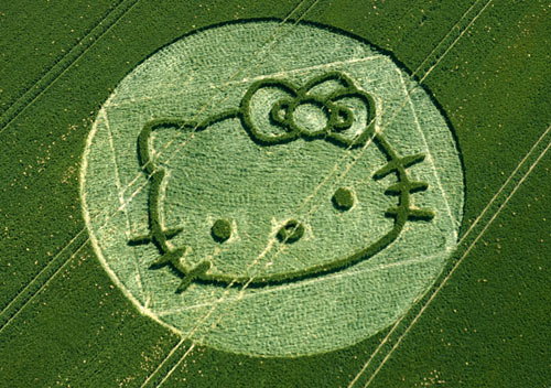
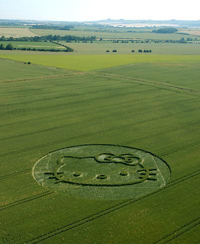
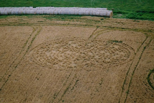
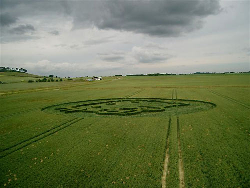
Images Steve Alexander Copyright 2004
| Location: |
Yatesbury, nr Cherhill, Wiltshire.
(THIS IS NOT A CROP CIRCLE)
|
||
| Map: |
Explorer 157 SU 067704
|
||
| Crop: |
Wheat
|
||
| Description: |
 |
||
| Discovery: | 27th June | ||
| Name: | Tony Hughes |
|
|

|
|
||
| Status: | This crop pattern was created during the day and the Crop Circle Connector team witness its creation on several occasions during the day. | ||
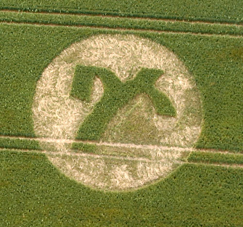
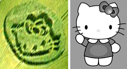 I worked on the photos of the Yatesbury man-made formation for Japanese TV. It shows "Hello Kitty" a famous Japanese comic character for kids, used widely in kids products and toys. It was made for "Hello Kitty" 30th aniversary. Andreas Muller |
|||


| Location: |
I have just seen a new formation which seems to span several fields, between the villages of Stoford (A36 just outside Wilton/Salisbury) and the Woodfords, and crossing the Devizes Road. It is just South of Stonehenge |
| Map: |
|
| Crop: |
|
| Description: |
|
| Discovery: | 26th June |
| Name: | Christian Kyriacou |
| Status: | STORM DAMAGE |
| Location: |
On south side of A4, between Marlborough and Froxfield, in a field on the edge of Savernake |
| Map: | SU235676 |
| Crop: | Corn/Wheat |
| Description: | Small circle with figure inside, not sure what of |
| Discovery: |
24 June 2004 |
| Name: | Diane Pitcher |
| Status: | This location was visited on the 19th June and it was discovery that it was a crop shape created for a commercial product. THIS IS NOT A CROP CIRCLE. |
| Location: | Ebbsbourne Wake |
| Map: | |
| Crop: | Oil Seed Rape |
| Description: | |
| Discovery: |
26th June |
| Name: | |
| Status: | After looking on the
map across Wiltshire I was unable to find this location, can someone
help? suspect formation does not exist. |
| Location: | Aylsham, Norwich. |
| Map: | |
| Crop: | Rye |
| Description: | A single circle approximately 6-8' diameter |
| Discovery: |
December 2003 |
| Name: | John Sayer |
| Status: |
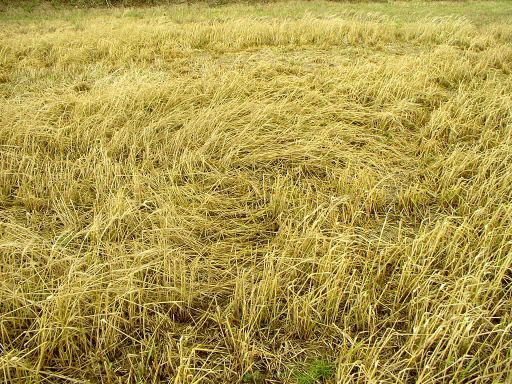
Fields of mature rye (?) were noticed in Norfolk back in December
2003 at Marsham, Aylsham and Frettenham (the first two locations
having hosted crop circles previously). This 6 - 8 ft diameter
clockwise circle was seen in the field at Aylsham at the end of
January. By the time the photos were taken the crop had been fairly
battered by rain and snow. Several areas of the field had also
suffered rook and rabbit damage.
Image John Sayer Copyright 2004 |
 |
|
Bishop Cannings Down, nr Beckhampton, Wiltshire. Reported 1st May. |
|
05/05/2004 |
| Location: | |
| Map: | |
| Crop: | |
| Description: | |
| Discovery: |
|
| Name: | |
| Status: |
Image Use Policy (Please Read)
CHECK THE WEATHER FOR VISITING CROP CIRCLES
The Crop Circle Connector suggests you
visit the link below
before visiting this year's crop circles in England.
Follow the Countryside Code whilst visiting Crop Circles

![]()