|
Code: SUSSEX 2004/02
Location: FALMER, NR LEWES, EAST SUSSEX
First reported: 28th May 2004
Crop: Barley
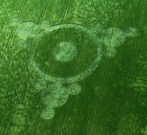
Design: Ringed circle with three attached 'triangular triplets' at
regular
intervals
Dimensions: Around 400ft total diameter
Surveyed by: ALLAN BROWN, DAN VIDLER and ANDY THOMAS, 1st & 2nd June
2004
REPORT: David Marras first reported seeing this
formation, on the Lewes side of Falmer, on 28 May. He thought it might
be wind damage, but on our inspection on 1st June it was found to be a
proper formation, as described above.
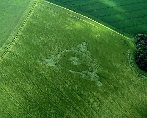
The formation is not visible from anywhere except
the path that runs from the lay-by at Newmarket Hill (site of two
formations last year) to a prominent copse of trees to the east. It
can be seen when looking north from the path, but is very hard to
discern, and at first glance could pass for wind damage, as the pattern
sits on the brow of a hill in the field and can only be seen
obliquely. The lay inside at first appears rough, but it seems much
crop recovery has taken place and the pattern may have been there a
week or more before we inspected it. The design is regular and
pleasing, however.
Because the formation was already several days old,
it was initially almost impossible to make out the original lay of the
crop. In fact, everything appears to have been laid in a clockwise
direction, but the crop had grown back up from its prone position so
vigorously and then collapsed either to the left or the right, that it
gave the impression that the lay was almost random in its nature, or
that the design was made up from wind lodging.
Despite this haphazard looking lay, we think the
formation would have originally looked very neat and orderly, which
David Russell's aerial shots clearly suggest. Walking around it
immediately left a level of damage that was not apparent when we first
walked in. The crop didn't look particularly kinked, broken or
damaged. The outer satellites of the design have certain similarities
to the Sompting "Triangular Triplets" that appeared in 1993 and 1999,
although the proportions of this are somewhat different. The most
impressive feature is the delicacy with which the various circles touch
each other, leaving small gateways to walk through. These gateways are
gaps of 2-3 feet or less, sometimes just a thin veil of single
stalks. To maintain this level of accuracy over the whole formation is
a very impressive achievement, especially as there are no clear signs
of any underpaths leading to the centres of the various component
circles.
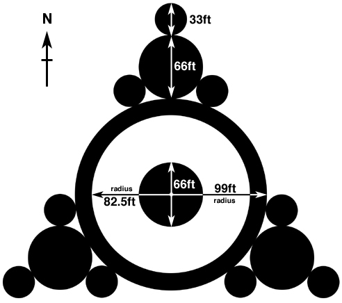
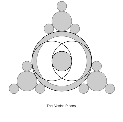
Geometrically, it is a very simple and pleasing
design. Its dimensions, in feet, reflect its basic design tenet, that
of the 'vesica pisces' and the 1/3rd - 2/3rd proportions it
generates. The outer circles of the triplets are 33ft diameter, while
the central circles of the triplets are 66ft (as is the central
circle), with the distance to the outer ring being 99ft radius. Clearly
the equilateral triangle is the governing geometric device, which
generates the octave and a basic diatonic ratio. A lot of fun can be
had from drawing the various equilateral triangles that exist within
this design.
The formation is placed in the middle of an
unexpectedly peaceful and isolated spot, which affords a lovely view
out through the pass between Mount Caburn and Firle Beacon to the
south-east of Lewes. In fact, from here you can look onto the fields
of three of last year's formations, and one of 2002. From Hollingbury
Hillfort, which at the moment appears to sit at the hub of a host of
radial sightlines, one can also see the sites of several formations
that have appeared in nearby fields over the last couple of years. The
latest formation is just fractionally below a direct sighting from
Hollingbury.
As a historical note, the copse of trees alongside
the field is reputed to be grown in the shape of a boot, while the
farther copse to the south represents a hat. These were planted to
commemorate the Duke of Wellington's victory against Napoleon at the
Battle of Waterloo in 1815.
Report by ANDY THOMAS & ALLAN BROWN, 4th June 2004
Southern Circular Research
|