|
CROP CIRCLES IN 2000 |
|
Cherhill, nr Calne, Wiltshire. Reported 27th April
GPS Reference SU 0419 6969
Updated Thursday 18th May 2000
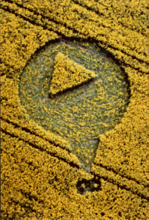
Image Francine Blake (Wiltshire Crop Circle Study Group) Copyright 2000
Saturday and Sunday 15th/16th July 2000

Click on Thumbnail to enlarge
Image David Russell (Southern Circular Research) Copyright 2000
FIELD REPORT
 |
 |
 |
 |
Images Stuart Dike Copyright 2000
Click on Thumbnails to enlarge
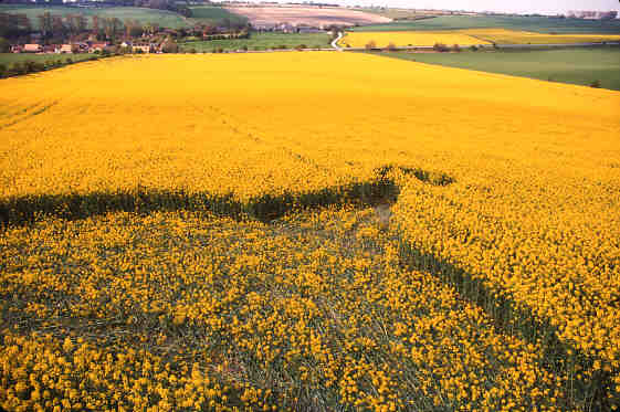
I have always regarded the ancient hill fort of Oldbury, and its White Horse, as one of the gateways to the ‘Home land’ of the Crop Circles. The general area, is of course very close to the Stone Circle of Avebury, and has once again become of the first location for the opening of the 2000 crop circle season.
The formation appeared on the morning of the 27th of April in Oil Seed Rape. The crop was in full flower, and around 5ft in height, but the ground was very soft, due to the rather inclement April we had been experiencing. The bank holiday weather was a blessing, and a much welcomed change from the weeks of rain, which is probably why we have had such a slow start to the season.

Diagram Stuart Dike Copyright 2000
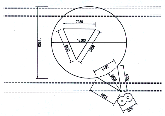
It is positioned high on the slopes, just below the Cherhill monument, and is facing down the hill off to the northeast. The general design consists of what you can only describe as a tear drop shape, with an inner central triangle, made up of standing crop. Pointing off to the northeast, is a triangular spur, which tapers into one of the two tramlines that the formation covers. Just below the spur, are two satellite grapeshot circles only 7ft in diameter, which are joined together, with standing crop within their centres. Both are flowing in a clockwise rotation.
The main floor pattern within the formation had two directional flows around only two sides of the central triangle. The crop around the outside edge of the formation had a general anticlockwise rotation, but changes direction to clockwise on the outer edge of the triangle. The West Side of the triangle has a flow in unison with the main floor pattern.
The inner triangle of standing crop had three sides of slightly different lengths. 29, 27, 26ft respectively. The overall diameter varied from 60ft, taken from the northeast and 57ft from east to west. The spur facing down the field, was 18ft long, and finished on the eastern tramline.
Survey Diagram Stuart Dike Copyright 2000
A fascinating correlation maybe found from the Kent formation, which appeared only days before the Cherhill design. Both of these formations boast a central triangular design, but hundreds of miles from each other! Is there a link? It has certainly raised a few eyebrows within the crop circle community, and has hopefully sparked what will surely be an exciting season ahead!
Report by Stuart Dike
![]()
CHERHILL,
APRIL 27TH 2000By Steve Alexander & Karen Douglas

Diagram Michael Glickman (Crop Circle Radius) Copyright 2000
CROP CIRCLES IN THE YEAR
2000 - Steve Alexander & Karen Douglas
share some of their recent crop circle experiences in this unique and
beautifully
illustrated series, exclusive to the Crop Circle Connector
Good Morning (and a nice one it is too) I am sat next to a colleague who is too shy to mail you.
He lives in Cherhill, Wiltshire, and has seen a new circle, he says it is clearly visible from the A4, in Oilseed Rape (Not the All Cannings rumour).
The location of this is somewhere on the hill between the White Horse and the Monument. Apparently it is a circle with a spur coming off.
I have no further details at the moment, but will be passing that way this evening, with a digital camera. If it's as clear as he says, I'll take some
shots of it. Incidentally, he's really into the circles, and spots them way before me, so
I believe this is very likely to be one. If you are in the area today, please go and check it.
Also, to embarrass him, his Name is Peter Harries! Hope it's the first clear one of the year!
Reported by Martin Ford