INTERNATIONAL
CROP CIRCLE |
Updated Wednesday 31st August 2005
|
Greene County, Ohio
A series of 'randomly-downed' areas in 9 foot tall corn were discovered by a photographer on a routine photo flight the day following a severe storm that passed through the area. This flattening included both straight lines, curved lines, and three generally circular areas. One of the circular areas has a radial lay. Here is an aerial photo:
Photo © George Bieri) The entire field was also 'pockmarked' with flattened areas of 2-3 feet across; this type of 'pockmarking' plant damage has only been reported a few times previously, once from Italy in the early 1985, and once from the UK in the late 1980's are two that come to mind. Much of the flattening was not all the way to the ground, but anywhere from 2 inches above the ground to 6 feet above the ground - this has resulted in creating woven 'canopies' which one can walk underneath, as well as some woven areas a couple of feet off the ground which can be walked on; many unusual lay patterns were found. Expulsion cavities are present, and initial examination indicates elongated nodes are present, although a full L-NEAT test has not been done yet. This formation is still being more thoroughly investigated, and there will be more ground photos and details to come (we've had to suspend our investigating plans for a couple of days as the rain from the remnants of hurricane Katrina is passing through the area of the next couple of days). This formation is in the same county as the "herringbone"-weave rectangular formation that appeared in early July as reported by BLT, Inc. Neither landowner of the formations in Greene County want the exact locations revealed nor are they allowing visitors other than the initial investigative teams, but here is a map showing the general locations of both formations in proximity to last year's Miamisburg formation and to closer Native American mound sites: ![]() |
|
Canisteo, Steuben County, New York
One of the senior meteorologists for the National Weather Service reported that two circular areas were found flattened in corn after investigating damage from an F1 tornado that went through the area. The circular areas were off the main track of the tornado by about 30-40 yards. The larger circle was approximately 30 feet in diameter, and the smaller one about 16 feet in diameter. The circular areas were not flattened all the way to the ground, but were only partially bent over:
In discussing the circles and the circumstances that led to their discovery with the NWS, I suggested that they examine their lightning data from the US National Lightning Detection Network array to see if anything unusual could be spotted around the time that the tornado went through the area. A preliminary examination by James Brewster revealed that several (rare) positively-charged electrical strikes were recorded by the network in the area around that time. Further details on this lightning analysis to come... |
| Location: | Kalispell, Montana,US, have eye sighting, but need photo's , any info' out |
| Crop: | wheat-have some bent crops |
| Description: | big |
| Discovery: | Maybe 2nd. week of Aug' 05 |
| Name: | Lawrence kennedy Ph.D-STARLINE UNLIMITED |
| Status | Waiting fro photographic Evidence |

|
What they've reported is a field with massive randomly-downed stuff all
through it (I got somebody to go and check it out).....furthermore it
had been cut and these people who reported it (who DID GO INTO IT)
didn't seem to realize this....
Nancy Talbott
BLT Research Team Inc.
|
|
Click on Thumbnails to enlarge I send you some photo about the hoax crop in Sala Baganza ( Parma ). You can see the imperfection of the figure. The plants are without modifications. Report and images Claudio e Patrizia Dall'Aglio copyright 2005 |
|
Dear All, Thanks to everyone who responded to our initial reporting of this possible RDF near Phoenix, Arizona. There were many helpful observations, commentary, and offers of field assistance which came our way. Here is what we now have been able to determine since the original report of information with photos by Rod 'Bearcloud' Berry: Linda Howe at www.earthfiles.com managed to convince KTVK Channel 3 in Phoenix to use their helicopter yesterday to acquire several aerial photos of the original RDF location which is close to Tolleson, Arizona:
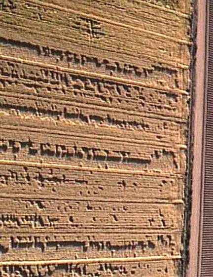
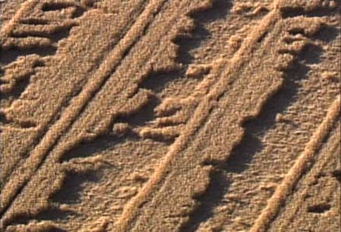
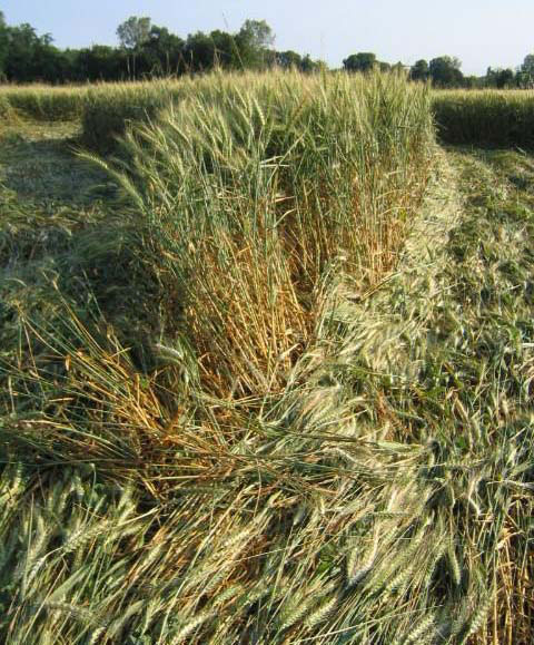
You will notice two things: (1) all the flattened damage is confined to the crop between the tramlines, and (2) there appears to be a somewhat regular pattern of polygons that have been both flattened and left standing:
[The crop has been identified as barley - not wheat as originally indicated.] Kathy Doore and Denise Wahlberg, both living in the Phoenix area, expressed interest in visiting the site, and went out and took additional pictures on Sunday, May 22. They have their photos up online at this website: http://www.labyrinthina.com/phoenixcropformation.htm They report that the formation did come down close to a water source (an irrigation ditch) which you can see in this photo (where they crossed to get into the field):
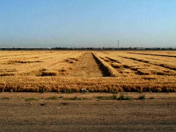
They also report that the formation was aligned due North-South:
This was confirmed by ground photos taken by KTVK Channel 3:
This damaged field was first spotted by Trent Johnson, foreman of Brooks Farms who leases and farms this field, sometime between May 11-15. This damage occurred after they flood-irrigated their field (along the tramlines) and after the area experienced a sustained windstorm (winds gusting to 50 mph). Mr. Johnson believes this was directly responsible for the damage. He also indicates that the flattening was confined to the area only between the tramlines as a result of the previous season's planting of cotton, some of which is still growing in-between the tramlines strengthening that section of crop - protecting it from the damage received elsewhere in the field. KTVK reports that two other fields nearby also received similar damage (no photos). Expect a more detailed interview with Trent Johnson to come from both KTVK and Linda Howe's Earthfiles. Bearcloud, Kathy, and Denise pointed out that the satellite photo from Google Maps I provided in the initial report appeared to not be in the correct location. I verified this. Google's map was off by a few blocks. It appears to be that Google Maps is just a bit off from the map location when you switch back and forth with the satellite view. Here's is what I've been able to identify now as to the locations on the satellite photo:
I wrote to Google to notify them of this, and to see if they could provide a date for when the photo was taken. Here is the reply I received - We strive to acquire the highest quality content for the satellite images displayed in Google Maps (beta). Most images are approximately one to two years old. >Although the frequency of updates may vary, we strive to refresh our data consistently. Regards, The Google Team Basically, that's not much of an answer. The primary reason that Bearcloud, Kathy, and Denise were confused by the Google photo is lack of a Wal-Mart which was located nearby. In the above satellite photo the Wal-Mart doesn't exist - which means the photo was taken before the Wal-Mart was built! Here is the most updated satellite photo of the area I could find from September 1, 2004 (which shows the Wal-Mart - the big white building in the center of both photos):
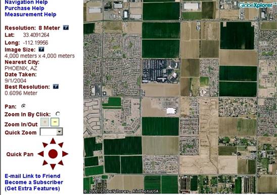
This means that the three parallel lines 'event' that appears in the Google satellite photo is at least a year old, and perhaps older. This leaves us with unanswered questions about that event, such as: when did it occur, what is the nature of that damage, and why does appear to be aligned with this year's event? Again, thanks to all who were involved in tracking down and investigating this report so quickly! The ICCRA cooperation and collaboration process is working well! Thanks especially to Bearcloud, Kathy Doore, Denise Wahlberg, Linda Howe, and the reporters and producers of KTVK Channel 3 in Phoenix for their quick investigating and photos, and to Trent Johnson for his helpful cooperation! We will keep updating everyone as information continues... Sincerely, Jeffrey Wilson Director, ICCRA Independent Crop Circle Researchers' Association [International] (cell) 734-891-2689 (email) jeff.wilson@asmnet.com UPDATE
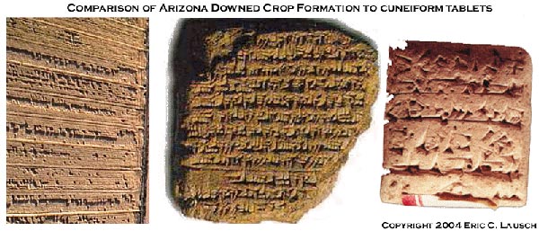
Hope all is well and hope to see you soon. On the AZ downed crop
formation... This may be a bit of a stretch but it will certainly
please all the Zacharia Sitchin fans in the audience...
Eric Lausch
|
| Location: | A report from Limassol, Cyprus near the UK Military base of Akroliri. |
| Crop: | |
| Description: | |
| Discovery: | |
| Name: | Jeffrey Wilson |
| Status | Waiting photographic Evidence |
|
The first American Crop Circle report is from Kansas City, Missouri, USA. BLT fieldworker JoAnne Scarpellini and new mother-and-daughter field-team Marlene & Daisy Stanley report that this "crop circle" is actually a piece of "land art" being created to celebrate the completion of a new levee along this section of the Missouri River floodplain. Ms. Betty Burch, mayor of Riverside, MO, states that the field design (which at this stage is mowed into a field of winter wheat) will not be completed until May 20th, and that the final pattern will include the installation of other plants. Attached photo, taken on April 26, 2005, shows a bull's-eye design of multiple mowed rings around an arrowhead; overall diameter approx. 300 ft. Surveyor's stakes are present in the field and it is clear that the design is not yet completed. The new levee--which now protects this section of floodplain along the Missouri River--has taken 10 years to complete and was constructed using 52% federal funding and 48% state funding. The city now plans to allow development in this area and the "land art" is, it appears, a way to announce the availability of the land for commercial use.
I am contemplating what might be indicated by the occurrence of the
first crop circle activity here in the U.S. in 2005 being so clearly
connected with commercial interests????
Nancy Talbott
BLT Research Team Inc.
It appears that the North American crop circle season has begun somewhat early this year! I just wanted to pass along some information about the first event reported here in the USA that has come to our attention. On Tuesday, April 26, 2005, three crop circle formations were spotted in a field along Interstate 635 south of Kansas City, Missouri. Rebecca Brink writes: "There are actually 3 different large crop circles right next to each other." Here is a photo of the central formation:
Ms. Brink also writes that since the formations were discovered, they have changed in appearance in two instances: (1) the central circle in the formation pictured above originally was 'hollow', but by the end of the first day, the 'hollow' had somehow been filled in with dirt (2) By the second morning, several additional "lines" had been added to one of the formations. We'll keep everyone up to date as additional details become available! Thanks to Rebecca Brink for passing along info on the formation including the above formation; thanks to David Kingston for originally posting details of the report, and to Ted Robertson for bringing it to our attention!
Jeffrey
Wilson
(cell) 734-891-2689 |
| Location: | |
| Crop: | |
| Description: | |
| Discovery: | |
| Name: | |
| Status |
| Location: | |
| Crop: | |
| Description: | |
| Discovery: | |
| Name: | |
| Status |
Image Use Policy (Please Read)
The Crop Circle Connector 1978 - 2004 Picture archives
The 1978-2004 Archives are open to members of
the Crop Circle
Connector Membership only.
Click
above to join the Crop Circle Connector Membership
SUBSCRIBE ONLINE WITH PAYPAL
The Crop Circle Connector suggests you
visit the link below
before visiting this year's crop circles in England.
Follow the Countryside Code whilst visiting Crop Circles