|
|
|
Avebury Stone Avenue of May 8, 2008
showed two "teardrop" motifs that
were aligned in the field with sunrise near latitude 17.5
degrees North on its date of appearance,
thereby providing a latitude code for the Olmec heartland of La Venta, Tikal and
Palenque
This Page
has been accessed

Updated Sunday 18th May 2008 |
|
Last week a new stunning crop picture appeared
in oilseed rape near Avebury Stone Avenue. It was
photographed elegantly by Janet Ossebaard (see
www.circularsite.com) and Bert Janssen (see
www.bertjanssen.nl/cropc). At first there was
some confusion over its geographical
orientation, whether
east-west or north-south? Fortunately after a few
days, Mark Vidler determined a highly accurate field
orientation as 72.5 degrees (slightly north of east)
to 252.5 degrees (slightly south of west).
Indeed, I will show
below how his GPS values agree well with solar
alignments at sunrise or midday (noon) for May 8,
the day when that crop picture appeared. But then
Mark is an expert at such matters! See his book
"The Star Mirror: extraordinary discovery of a true
reflection between heaven and earth" on
www.amazon.com/Star-Mirror-Mark-Vidler/dp/0722537204.
Some people have suggested that
this new
crop picture might show a "yin
yang"
symbol from ancient
China.
That is true in part, but there is also a deeper
truth which requires further study. I will
show below that its
similarity to a yin-yang symbol comes about, because
that symbol was derived in ancient
China from
studies of
megalithic sundials. Similar studies were carried
out in the ancient British Isles. Hence today we
sometimes see the same "teardrop" or "yin yang"
shape in British crop pictures.
It is a universal astronomical symbol that means
"variation in length of the Sun's shadow over one
year".
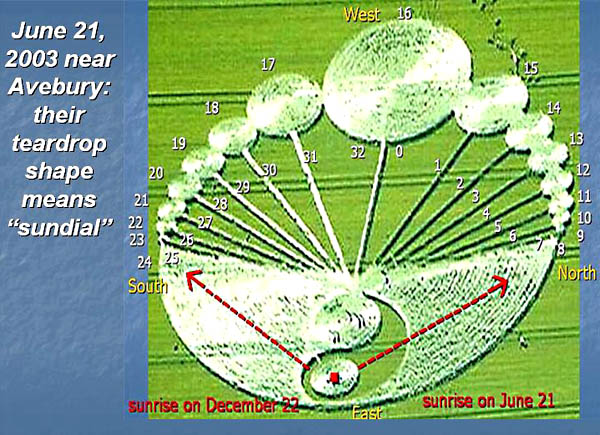
Avebury of June 21, 2003 showed a single
"teardrop" motif which means
"sundial" in the British
megalithic calendar
Before proceeding to the May 8
crop picture, we must first explain a few of the
symbols which those crop artists use to tell us
things. And the only way to do that is by careful
study of crop pictures from the
1990-2007 archives (see
www.cropcircle.tv). Five years ago on the summer
solstice of 2003, a beautiful and informative
"sundial" picture
appeared near Avebury while celebrations were
going on nearby. Yet no one seemed to notice (see
www.cropcircle.tv/archives/2003/wadenhill/waden2003a.html):
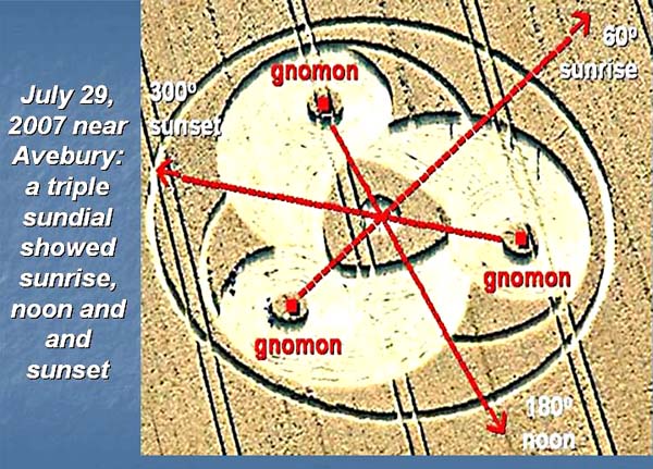
Avebury of July 29, 2007
showed three "teardrop" motifs that provided
a "triple sundial" for its date of appearance
Last year on July 29, a
magnificent "triple sundial" appeared close to
the Red Lion at Avebury. It showed three
different "teardrop"
motifs, suggestive of three shadow-casting
sticks or gnomons in
combination:
When Janet
Ossebaard and I walked that crop picture, and
studied its three gnomons using a compass (see
the three red squares above), we found
that each gnomon was aligned toward either
sunrise (60 degrees), noon (180 degrees) or
sunset (300 degrees) for its
July 29
date of appearance
(see
www.cropcircle.tv/archives/2007/greenstreet/greenstreet2007.html).
A similar triple-symmetry of the Sun occurs at one
other time during the year near Avebury: namely on
May 9, when the sun rises at 60 degrees, proceeds to
180 degrees by noon, then sets at 300 degrees. Both
dates lie almost equidistant from the summer
solstice on June 20. Thus in the context of modern
crop circles, "teardrop" means "sundial" or
"gnomon".
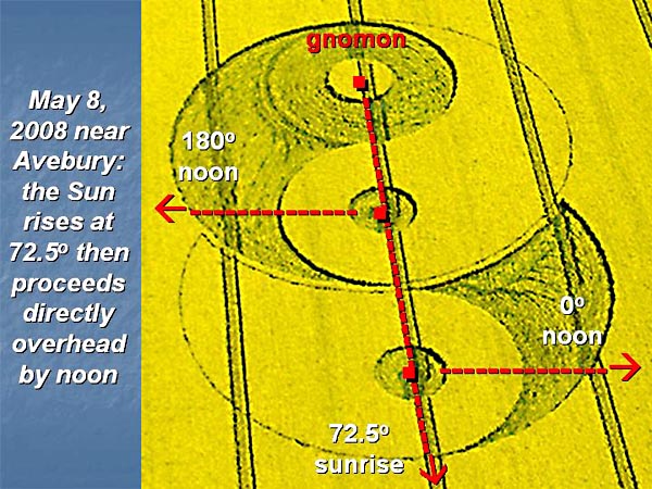
Avebury of May 8, 2008:
the Sun rises at 72.5 degrees then proceeds directly
overhead by noon
Now on May 8, 2008,
we saw two "teardrop" shapes proceeding outward from
a single gnomon:
Mark Vidler carefully aligned that picture by GPS as
running slightly north of east at 72.5 degrees (or
72.338 by a recent email) to slightly south of west
at 252.5 degrees. Its one "standing circle" lies off
to the east at 72.5 degrees. Those data immediately
suggest some kind of alignment with "sunrise"
because, on May 8, the Sun rises slightly
north of east all over Earth in the northern
hemisphere (whereas it sets slightly north of
west).
I therefore used an astronomical almanac
(see
http://aa.usno.navy.mil/data/docs/AltAz.php)
to determine at which latitude in the northern
hemisphere, our Sun might rise at 72.5 degrees on
May 8? The results are listed in Table 1 below.
Table 1. Azimuths for
sunrise or sunset on May 8 versus northern latitude on
Earth
|
Latitude
North (degrees) |
Sunrise
(degrees) |
Sunset
(degrees) |
|
0 |
72.8 |
287.3 |
|
10 |
72.4
|
287.7 |
|
20 |
71.4 |
288.6 |
|
30 |
69.6 |
290.4 |
|
40 |
66.9 |
293.4 |
|
50 |
61.9 |
298.4 |
|
60 |
52.5 |
307.8 |
Those "sunrise" data seem to
match anywhere from 0 degrees (the equator) to 20
degrees North. Not a very precise fit! Note,
however, that the measured field alignment of 72.5
degrees lies a full 10 degrees mismatched
from sunrise at Avebury on May 8 (latitude 51 N). So
they are definitely trying to tell us about some
geographical location on Earth other than Avebury in
England.
Now we may ask a second
question: at which latitude on Earth does the Sun
lie directly overhead at midday (noon) on May 8? In
other words, where does it lie halfway between 0
degrees North and 180 degrees South, as implied by
the new crop picture above?
After the Sun rises, it may
proceed either North or South to reach
maximum altitude at midday. At Avebury near 51
degrees North, it always goes South. Near the
Equator it goes South for six months, then North for
six months. So where was the boundary line between
North and South on May 8? The results are listed in
Table 2 below.
Table 2. At which
latitude does the Sun lie directly overhead on May 8 at
noon?
|
Latitude
North (degrees) |
Maximum
altitude (degrees) |
North-South alignment (degrees) |
|
0 |
72.7 |
0 North |
|
10 |
82.7 |
0 North |
|
16 |
88.7 |
0 North |
|
17 |
89.7 |
0 North |
|
18 |
89.3 |
180
South |
|
19 |
88.3 |
180 South |
|
20 |
87.3 |
180 South |
|
30 |
77.3 |
180 South |
Now we get a much more precise
fit to one particular geographical latitude between
17 and 18 degrees North. The same value follows from
a "sunrise" relation of (90.0 - 72.5) = 17.5
degrees.
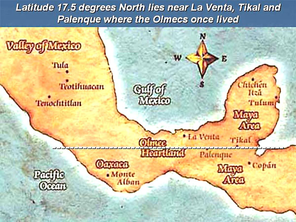
Where on Earth could they be
talking about? Any longitude might match those
observations. Yet in the context of many other crop
pictures from England which show Aztec-Mayan themes,
I found it interesting that the derived latitude of
17.5 degrees passes directly through the ancient
Olmec heartland of La Venta, Tikal and or especially
Palenque (see
http://en.wikipedia.org/wiki/Palenque).
.
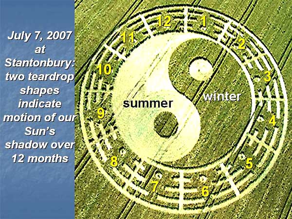
Stantonbury of July 7, 2007
showed two "teardrop" motifs surrounded by "12
months"
Now we will address
a second issue. Why should a "yin yang" symbol
appear in certain English crop pictures, if they
relate to astronomical topics such as sunrise or
sunset, rather than to Taoism or the I Ching?
The clearest example of a "yin yang" symbol appeared
in crops at Stantonbury on July 7, 2007. There we
saw two "teardrop"
motifs in combination, just as for a yin-yang symbol
from ancient China
(see
www.cropcircle.tv/archives/2007/stantonbury/stantonbury2007.html):
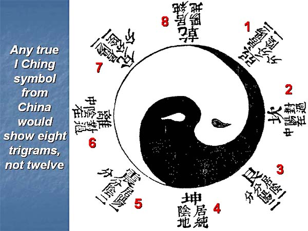
But wait! When
we look more closely, do we see the
"eight
trigrams"
that should surround any
Chinese yin-yang symbol? No, instead we see
twelve other
symbols (yellow numbers 1 to 12) that may be
interpreted rather simply as the twelve months of
any year. Each "teardrop" seems to represent six
months, whether the "light summer" or "dark winter"
half of a Celtic year.
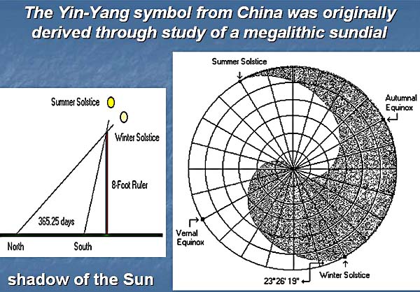
The
"teardrop" or "yin yang" symbol: variation in length
of the Sun's shadow as measured over one full year
"When observing the yearly
cycle of our
Sun, ancient Chinese astronomers used
a pole about 8 feet long, and
posted it at a
right angle to the ground.
Then they recorded the length
or position of the Sun's shadow
over a full
year at various
times of day.
Next they drew
six concentric circles, divided those circles
into 24 yearly parts, and recorded the length of the
Sun's shadow at
noon on any day:
After connecting lines, they next
drew a sun-shadow chart as
shown above. The light-coloured
area indicates more sunlight
and is called 'yang'
(Sun). The dark-coloured
area indicates less
sunlight and is called 'yin'
(Moon)."
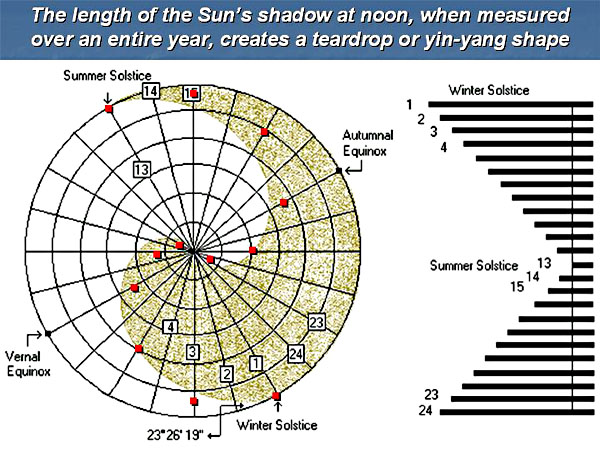
I
decided to evaluate that hypothesis more accurately,
by using sun-shadow lengths as calculated from a modern
astronomical almanac. Those data are listed in Table 3
below.
Table 3. Length
of the Sun�s shadow at noon for a vertical sundial at
latitude 23o N
|
Yearly
date |
Offset
from vertical of the Sun�s shadow at noon |
Relative
length of the Sun�s shadow at noon |
|
June 21 |
0 degrees |
0.0
polar |
|
July 21 |
3 |
0.3 |
|
August 21 |
11 |
1.1 |
|
September
21 |
22 |
2.3 |
|
October 21 |
34 |
3.9 |
|
November 21 |
43 |
5.4 |
|
December 21 |
46 |
6.0 |
|
January 21 |
43 |
5.4 |
|
February 21 |
34 |
3.9 |
|
March 21 |
22 |
2.3 |
|
April 21 |
11 |
1.1 |
|
May 21 |
3 |
0.3 |
|
June 21 |
0 |
0.0 |
The length
of the Sun's
shadow was
calculated above
as the
tangent of its
offset from the
vertical When
plotted in polar coordinates, those
almanac data (red squares) do indeed produce
a "teardrop" or
"yin yang"
shape, just as our crop artist friends keep showing
us in the fields:
One could also
produce a "heart" shape,
if the same data
were plotted with
left-right symmetry.
Some crop pictures do show "hearts" to describe the
periodic up-down motion of our Sun (or Venus)
through Earth's sky.
Who made the new May 8 crop
picture, and what are they trying to tell us?
Over the past few years, we have seen a series of
"sundial" motifs in crops: see
www.cropcircleconnector.com/anasazi/sundials2007b.html.
Quite a few of those could be verified as paranormal
in origin, by finding exploded or bent nodes in the
fallen plant stems. At first I wondered whether the
new "double sundial" which appeared at Avebury Stone
Avenue on May 8 could have been made by local human
fakers? But then I noticed off-centre circles that
could not be made easily using rope or boards, plus
other fine details of that nature, which led me to
consider a paranormal origin instead.
The next problem was to determine its precise field
orientation, relative to the four compass directions
north, south, east or west. No sundial can be read
properly unless its precise field orientation is
known. More confusion then ensured, until Mark
Vidler accurately measured its field orientation as
72.5 (slightly north of east) to 252.5 degrees
(slightly south of west).
Immediately we began to think that it could be
aligned with early summer sunrise, somewhere in the
northern hemisphere. But where exactly? Looking at
the horizon azimuths for sunrise on May 8 is not
that informative (Table 1 above), because almost all
values of latitude from the equator (0 degrees
North) to the Tropic of Cancer (23 degrees North)
fit those field data pretty well.
But when we add an additional condition: namely that
the Sun should lie directly overhead on May 8 (when
the crop picture appeared), then we found a fairly
precise zone of latitude between 17 and 18 degrees
North (Table 2 above). In other words, the new
Avebury crop picture shows us a "code for latitude"
on Earth, just as many other sundial-type crop
pictures did from 2003 to 2007
(see
www.cropcircleconnector.com/anasazi/sundials2007b.html).
So far, so good. They are telling us about "17.5
degrees North latitude". That number follows also
from the simple relation (90.0 - 72.5) = 17.5. Why
would any faker align the new crop picture towards
early summer sunrise on May 8, for somewhere on
Earth far from Avebury itself?
The next question is really critical: which region
of Earth are they trying to draw our attention to? I
used Google Earth to scan the entire globe for that
particular latitude, and was immediately struck by
the fact that many ancient Olmec ruins in central
America: namely La Venta, Tikal or Palenque,
intersect that narrow zone of latitude precisely
(see
http://en.wikipedia.org/wiki/Mesoamerican_chronology).
Another link to Mayan-Aztec culture and
their great teacher Quetzalcoatl?
An obvious question therefore arises: could
Quetzalcoatl have been an extra-terrestrial visitor
to early Earth, say as part of an "Interstellar
Peace Corps" to help the natives become more
civilized? Did he live and teach on Earth long
ago, in much the same
way that modern Europeans or Americans
send aid workers to poorly developed regions of
Africa or Asia? And could he or some of his
colleagues be making modern crop pictures today, as
a prelude to open contact in the near future?
They tell
us repeatedly in
newspapers or on TV that "there
are no aliens visiting Earth today".
Furthermore, they
keep insisting
that "no
extra-terrestrials ever visited Earth in the past
either." But
consider for
example the Pyramid of Quetzalcoatl in
Chichen Itza, where a huge "feathered serpent"
was carved onto
one face,
so that his shadow would descend
symbolically from heaven to earth on
any equinox (see
www.sacredsites.com/americas/mexico/chichen_itza.html
or www.youtube.com/watch?v=vQsqpG0XN0g&feature=related).
What could the
original builders of that pyramid possibly have been
thinking of? Surely they knew that Quetzalcoatl was
an extra-terrestrial visitor to central America in
their recent past? Yet modern humans today never
came into contact with such important information,
perhaps in part because Spanish
invaders burned practically all written records from
central America after they invaded in 1519.
Some crop pictures even suggest that Quetzalcoatl
(or his colleagues)
approached
us fairly
recently (and
secretly) during
in the 1950's. They
apparently asked us then
to give up our nuclear weapons, but
we refused
(see
www.cropcircleconnector.com/anasazi/time2007o.html).
Now as we approach the end of the Fifth Mayan Sun
in December
2012, those great
and ancient teachers seem to be getting ready
to come again!
The new crop
picture from Avebury Stone Avenue, and others which
will appear shortly in 2008, seem to be intended
to prepare us for their return.
Notes
Mark Vidler has kindly made two
suggestions to help improve the manuscript.
Q1. A Figure Legend reads as follows: "On May 8,
2008 near Avebury, the Sun rises at 72.5 degrees,
then proceeds directly overhead by noon." The
casual reader might misunderstand this to mean that
the Sun at Avebury proceeds overhead by noon. The
Sun is never directly overhead outside of the
Tropics.
A1. I agree completely, and wrote
that Legend simply to make a difficult crop picture
more accessible to non-experts. By showing sunrise
at 72.5 degrees, then by implying through two
"teardrop" shapes that the Sun may proceed either
North or South to reach overhead by noon, those crop
artists are definitely trying to tell us that their
May 8 picture cannot refer
to Avebury at latitude 51 degrees North. Rather it
must refer to somewhere south of the Tropic of
Cancer at latitude 23 degrees North. Indeed, they
showed a latitude picture of Earth at Abbott's Down
on June 6, 2007 which seems to indicate their
familiarity with the subject
(see
www.cropcircle.tv/archives/2007/abbotsdown/abbotdown2007a.html
or
www.lucypringle.co.uk/photos/2007/uk2007aj.shtml#pic4).
Both of those observations, when
interpreted in terms of other latitude codes from
past sundial crop formations 2003-2007
(see
www.cropcircleconnector.com/anasazi/sundials2007b.html),
led me to consider a tropical latitude of "17.5
degrees North" for a likely solution to the May 8
crop picture, because that is where the Sun lies
directly overhead on May 8. As a confirmatory
relation, we see that (90.0 - 72.5) for sunrise
equals 17.5 degrees.
I would prefer to leave the
Figure Legend as it stands, because the title reads
"Olmec heartland of La Venta, Tikal and
Palenque" which should convey to most readers
that we are not talking about Avebury. Also I added
a map of southern Mexico, showing how 17.5 degrees
North intercepts all of those ancient cities.
Interestingly enough, all prior
sundial crop formations gave latitude codes for the
Avebury region of southern England, or for further
north near Callanish or southern Norway. This is the
first sundial picture, to my knowledge, which shows
a latitude code for much further south near
the equator, possibly in southern Mexico.
Q2. Another problem is that the
"arrow" on that diagram seems to indicate
that "sunrise" may be pointing to the west.
A2. Any megalithic sundial
contains a shadow-casting rod or gnomon, which is
indicated in the new May 8 crop picture by a circle
of standing crop off to the east. Indeed, those crop
artists drew another big circle around it
in fallen crop, if you look at the photographs
carefully. Hence they are trying to get us to
imagine that "rays of the rising sun" are going past
that gnomon from east to west, just as the arrow
indicates.
Similar principles were followed
long ago in China: see "Science and Civilization
in China" by Joseph Needham, or "The
Shorter Science and Civilization in China: an
abridgement by Colin Ronan ", especially its
discussion of sundials or gnomons, freely
available on
www.amazon.com/exec/obidos/ASIN/0521315360.
Thus the "yin yang" symbol from ancient China is
formally equivalent to a "teardrop" symbol that
appears sometimes in English crop pictures, and
means variation in length of the Sun's shadow over
one full year. Six months of every solar year are
"dark", while the other six months are "light".
Hence from such ancient concerns about solar
astronomy, we get the Taoist philosophy of yin and
yang. Or as Ursula LeGuin wrote more poetically in
1969 (see
www.greenmanreview.com/book/book_leguin_lefthand.html):
"Light is the left hand of
darkness
and darkness the right hand of light.
Two are one, life and death, lying
together like lovers in kemmer,
like hands joined together,
like the end and the way."
|
|
 |