St Catherine's Well, Loversall nr Doncaster. Reported 19th April.

Map Ref: SK564979

Updated Thursday 1st September  2005

Hit Counter


NEWS RELEASE

From Business Link South Yorkshire

Contact: Amrit Saroya

Date: 8th April 2005  

FARMER’S LANDMARK ADVERTISING CAMPAIGN!  

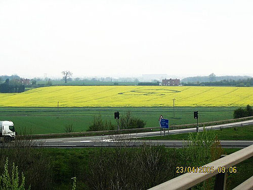
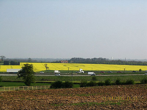
A Doncaster farm has adopted a unique way of generating an extra income by establishing the Business Link South Yorkshire logo into its fields. 

Brian and Mick Chappell of Quarry Farm, Loversall, are hosting the ‘three circle’ logo within one of their fields of winter oilseed rape. The field being used is located on the A1 junction and M18 interchange meaning that it is seen by thousands of motorist’s everyday. 

Given recent CAP reforms and the emerging Single Farm Payments, farmers in South Yorkshire have the opportunity to create an additional income or add value to their crops through innovative means. With the help of Business Link South Yorkshire the Chappell brothers implemented the idea, drilling the logo into their commercial oilseed crop.  

“Lots of farmers are using their fields to host portable advertising signs,” said Mick Chappell. “When Business Link approached us with the idea for advertising we thought it was a great opportunity especially as no other farmers we knew had tried it.” 

This new and novel way of advertising can offer the farm a valuable alternative income stream in the future if taken up by other Doncaster or South Yorkshire Businesses as well as adding value to their commercial crops.  

“This type of advert is great, it is constantly changing through the seasons and can be naturally altered to highlight the logo within the field,” says Patrick Thornton a Rural Business Advisor at Business Link South Yorkshire. 

“Although only a prototype the response to the advert has been staggering. Due to its location lot of people have seen the advert and commented on how unique it is as a form of marketing. It’s a great advertising opportunity for businesses in South Yorkshire and I hope to see more adverts like this out there”.   

For more information regarding ‘crop advertising’ contact www.landmarksandlogos.com

Notes to Editors 

·        Aerial shot attached of the crop circles 

·        For more information on this News Release, please contact Amrit Saroya on asaroya@blsy.com


Stretched Image Chris Watt Copyright 2005


Images  Dave Strickland Copyright 2005


Discuss this Crop Circle on the Forum

Seeing the crop-circle rumoured to be near Doncaster and living there (dated 19th April 2005), I was intrigued enough to go and visit and photograph it.  I am pleased to submit a couple of shots, taken from the M18 motorway, at the junction with the A1(M), around 0800h Sat. 23rd April, looking N-NE.  Loversall village is just off the field of view to the right.  It is impossible for me to know whether this formation is the work of humans or others.  I really need to see what the flattened areas of rape seed in a crop-circle look like close up.  I hope to get chance soon and take more shots.  The field containing the formation is next to the A60 which runs across the photos submitted. 

Curiously, at the other side of the M18 next to the nearby village of Wadworth are two or three intriguing circles in another field of rapeseed (Grid Ref. SK564979).  I could only manage a shot from the wrong side of the motorway which I submit herewith.  Put this down as a rumour.  Again, will try soon to obtain better shots.  

Report by Dave Strickland


UPDATE

The Loversall interlocking circles (SK569990) photographed looking due East across the A1(M) just before the junction with the M18. I was unable to enter the field itself.  However, the curious circles I photographed at the other side of the M18 near Wadworth village (SK564979) two days ago are no more than irregular patches of flower-deficient crop with no defined edges.  I entered this field and took the two extra shots submitted herewith. 

Report by  Dave Strickland.

Images Dave Strickland Copyright 2005

UPDATE 2

The Loversall circles discovered in yellow oilseed and reported in April have changed in appearance.  I  have taken new images of what the pattern looks like now (dated 5.6.05).  The crop has almost finished flowering in the field but is in full bloom within the circles, a "negative" image effect.  As far as I am aware there have been no previous examples recorded of such a change, so I thought the crop circle community would like to see the two images submitted with this report. 

Images Dave Strickland Copyright 2005


Location: Loversall nr Doncaster
Map: SK569990 and not SK564979 as stated at the head of the web file
Crop: Rapeseed
Description: As already posted
Discovery:

Ditto

Name: Richard Parr/Dave Strickland
Status: Waiting for aerial images

Location:

Approximately 5 miles south of Doncaster can be seen from the M18

Map:  
Crop: Oil Seed Rape
Description: Three rings
Discovery:

19 April 2005

Name: Richard Parr
Status: Waiting for aerial images

Location: St Catherine's Well,Loversall nr Doncaster.
Map: SK569990
Crop: Oil Seed Rape
Description: Three interlocking circles
Discovery:

19th April 2005 as a crop-circle rumour

Name: Dave Strickland
Status: Waiting for aerial images

Return to April 2005

  
Mark Fussell & Stuart Dike