|
|
|
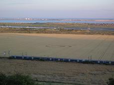
Hadleigh Castle, near Southend-on-Sea,
Essex. Reported 19th July.
Map Ref:
Updated Wednesday 20th July 2005

|
|
|
|
Note:
London Fenchurch St to Southend railway line next to it.
The position of it is quite unusual as it is near
water i.e. the river Thames Estuary as it goes into the North Sea.
Also about 500 years ago this would be sea, hence the castle which was
built in Henry VIII' s time. It may even be below sea level.
Also it is in a highly populated area -
Southend-on-Sea to the east, Canvey Island to the south and Benfleet/Hadleigh
(part of the Southend conurbation) to the north and west.
Map ref is: 856813OS Landranger 178 printed as
Hadleigh Marsh
Mark Chatterton
|
|
Images Mark Chatterton Copyright
2005
|
Just noticed on your site that there is a new circle
reported in Southend. In the Waden Hill formation on Sunday a man very
proudly told me that he and his mates had made a crop circle in Southend
recently. He did not describe the shape but did say it was not
complicated. This could well be it! Thought you would like to know,
Daniel Vidler |
| Location: |
Hadleigh Castle, near Southend-on-Sea,
Essex |
| Map: |
|
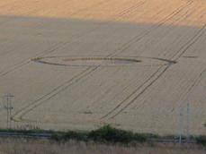
| Crop: |
Wheat |
| Description: |
Two concentric circles approx 20 metres
across with a smaller circle about two metres next to the main
circle |
| Discovery: |
19/7/05 (reported
first in Southend Evening Echo 20/7/05) |
| Name: |
Mark Chatterton |
| Status: |
Waiting for field report and aerial
shot. |
|
|
 |

