Updated Tuesday 27th August 1996
An aerial shots by Lucy Pringle Copyright 1996.
Field Report

Click on thumbnail to enlarge
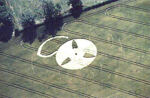
This formation is on the left hand side of the A32 coming from Alton, after the first sign posted direction to West Tisted. Unfortunately I was unable to enter the circle as an entrance to the field was not apparent and I was unable to locate a farmer/farmhouse. However I was able to observe the following. The crop appears to be wheat and consists of a main centre circle approximately 40-50ft in diameter. In the centre circle crop remains upright at the centre point and 3 'leaf' shapes at 120 degrees from each other, which appear to have been created from the intersections of 3 other circles which appear to be of identical size. Inside the 3 outlined circles are 3 smaller outlines which intersect with the circumference of the main circle and the outer outlined circles. Inside the smallest circles are marks which could not be determined from my position. Outlining the entire formation is a further circle approx. 100ft in diameter.

Click on thumbnail to enlarge
Also observed were trampled crop entering the field which ended in tractor tracks heading towards the formation. Attached to the main centre circle and following the circumference for approx. a third of the total distance is a 'tail' of crop approximately 1.5m/2.0m in width.
Report by Robert Speight 29/7/96
Images by Robert Speight. Copyright 1996,
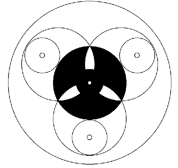
Diagram by Jeremy Robinson.
Copyright 1996.
Mindport Exhibits. Mindport@nas.com

