We have just received this great
report, on the Michigan crop
circles, by Jeffrey Wilson (ICCRA)
from the USA. He also included great
links at the end of his report.
Thanks also to Erik Adams for use of
his photo. (These circles were first
reported on this Wall about 17
postings below.)
Crop Circles Reported in the News
October 13, 2011 - BARK
RIVER-HARRIS-WILSON, MENOMINEE
COUNTY, MI
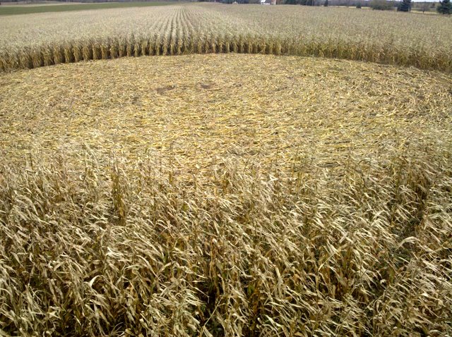
The two approximately 125 ft.
diameter crop circles swirled
counter-clockwise in corn were
discovered by Mark Jorasz as he was
harvesting a field near Harris,
Michigan on the afternoon of October
13, 2011. The two circles are not
visible from any nearby roads. After
notifying his father John Jorasz,
they examined the circles
extensively looking for tracks or
traces of human activity � they
found none. The downed corn stalks
in the two circles were still
intact, with each stalk bent to the
ground - with no damaged or broken
stalks, no displaced leaves on the
stalks and, out of the over � acres
downed area � found only 1-2 ears
that had become separated from their
stalks.
Each circle was in a different
variety of corn (one in 90 day
maturity corn, the other in 82 day
maturity), so when discovered, one
circle was found to be a little more
dried out than the other. One
circle�s stalks were still green.
There was no mold on any of the
downed corn stalks at the time of
discovery.
The Jorasz�s believe that the
circles were made sometime between
the afternoon on Monday, October 10,
and Thursday afternoon on the 13th
when the circles were found because
they had harvested the field across
the street on Monday and a
paraglider flew over the fields and
had not reported see the circles
then.
The Jorasz�s quickly agreed that
these circles were not the typical
bear-made type crop circles that
they have encountered in years past.
They explained that bears in this
region will forage into fields, sit
down in an area, and then as far as
they can reach around them will
proceed to eat the corn � this
leaves about a 6-9 foot �circle� of
damage before the bear moves on.
This damage too was unlike the wind
damaged flattening they have
encountered as recently as September
30-October 1 when a major windstorm
that dumped as much as two inches of
rain came through the area. John
Jorasz noted that most of his corn
fields� rows were planted East-West
which was perpendicular to the
direction of the recent windstorm�s
winds which blew generally
North-South. This caused much
wind-flattened corn in many of his
surrounding fields. The corn rows in
the field in which the crop circles
were in were planted North-South,
and so were unaffected by the recent
storm. There has been no rain in the
area since that time.
The field which contains the two
crop circles is quite isolated, with
forested wetlands bordering the
field to the east and west � each of
the forested areas containing
tributaries of Cedar River which is
located about 1.5 miles away. Advent
Creek runs less than � mile away
from the location of the circles,
before flowing into the Cedar River
. The circles are located about 8.5
miles from the shores of Green Bay
in Lake Michigan . According to John
Jorasz, the field may contain
springs because the soil seems to
take longer to dry out than
surrounding fields.
According to a Water Investigation
report published by the Michigan
Department of Environmental Quality,
Office of Geologic Survey written by
Kenneth Vanlier in cooperation with
the USGS titled �Water Investigation
2: Ground � Water in Menominee
County� � the area of ground which
contains the field with the crop
circles is composed of a least two
separate layers of limestone both
containing aquifers.
The two crop circles are aligned
generally East-West, and are located
on a slight incline with one circle
approximately 1-3 feet higher than
the other. There is a slight ridge
to the east of the circles in an
adjacent alfalfa field. The whole of
Menominee County has been heavily
glaciated during the last Ice Age,
which has left the entire area
comprised of Drumlins and Ground
Moraines on a NE-SW alignment which
can be seen easily on satellite
photos. The crop circles were not
aligned to this general flow of the
landscape.
The areas to the south and east of
the crop circles are part of the
Hannahville Indian Community, Band
of Potawatomi Reservation.
There have been three local news
stories about the Harris crop
circles:
� Crop Circle Mystery at Local
Farm�, Daily Press, October 14, 2011
http://www.dailypress.net
�Crop Circles Discovered in the U.P.�,
TV 6 Fox News, October 14, 2011
(Updated to include video)
http://www.uppermichiganssource.com
�Crop Circles? Family Remains
Baffled by Mysterious Patterns in
Field�, Daily Press, 10-15-2011
(This article makes reference to a
crop circle reported in nearby
Escanaba, Delta County, MI � July
24, 1965 which the Jorasz�s found
reported on our ICCRA website:
http://www.iccra.org
)
http://www.dailypress.net
Thanks to Eric Adams from WYKX radio
for calling the ICCRA to notify us
of the crop circles, and to John
Jorasz for taking the time to
discuss the crop circles with us.
Thanks again Jeffrey Wilson for
sending us this great report from
the USA.
http://www.iccra.org/