Independent Crop Circle Researchers’ Association
www.iccra.org
May 17,
2010 – Hidden Valley Lake, Lake County, California Multiple
RDF
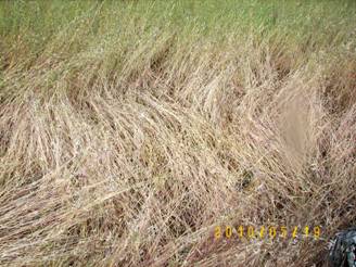
A report was made to California
MUFON about multiple, small, bright-white flying lights that were being
seen repeatedly for weeks in this valley. The witness, who reported
seeing the lights, also reported that they began finding what they
nicknamed “Lake county crop circles” in which the grasses which were
about 1.5 ft high then, pressed them down in odd rotations. In all, 32
of these patches of disturbed grasses were found. This appears to be a
type of RDF (randomly-downed formation):
Source: Anthony Tambini,
California MUFON CMS FILE NUMBER: 23359/ US-05182010-0017
June 6,
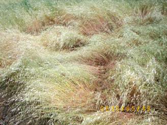
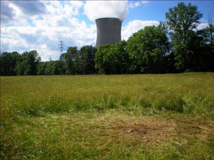
2010 – Moscow, Clermont County, OhioRandomly Downed Formation with Geometric Elements
I spotted this circle on a drive
along the Ohio River. It is located in a mixed grass field adjacent to
the coal-fired Zimmer Power Plant (the nuclear cooling tower in the
photo was designed and built in the 1980's, but the facility was changed
to be coal-fired after the Three Mile Island nuclear accident and never
had nuclear fuel there, but they still use the tower.).
The circle was 18'10" N/S in
diameter and 23'2" E/W in diameter. The additional flattened areas to
the west were a combined 74 feet in length total, with several swirled
areas and standing tufts.
The circle was nearly entirely radially-flattened, and there several
other non-geometric flattened areas connected to it via curved pathways.
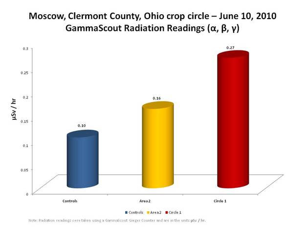
I was able to detect 2.6x higher radiation in the circle as compared to
control readings. After much internal ICCRA discussion, we decided NOT
to collect plant samples or examine plant samples, because of concerns
regarding contamination due to the remnants of a deer that had been
scattered throughout the formation. Deer bones and pieces were found
throughout the formation, scattered by scavenger birds and possibly
coyotes/dogs. The deer was NOT killed by the formation process -
firefighters located across the street from the formation recalled
seeing the dead deer that had been hit by a car alongside the edge of
the road. The deer had been dragged into the formation AFTER the
formation went down. All the bones and parts were lying on top of the
flattened grass. It was creepy though... I did however measure for
radioactivity:
The radiation readings taken on
June 10 inside the circle (Circle 1) were (on the average) over 2.5
times higher than the control readings. When using the
Independent-samples t-Test at Vassar Stats, the statistical results were
conclusive:
ResultsQ
Bottom of Form
Meana—Meanb
t
df
Top of Form
Bottom of Form
Bottom of Form
Top of Form
Bottom of Form
Bottom of Form
Top of Form
Bottom of Form
Bottom of
Form
P
one-tailed
Top of Form
Bottom of Form
Bottom of Form
two-tailed
Top of Form
Bottom of Form
The probability (P) results of
<.0001 for both the one-tailed and two-tailed indicates a very high
statistical significance.
The field where this formation
is located is just inside the village limits of Moscow, Ohio, and just
to the east of Little Indian Creek. The formation is located about 4.5
miles north of the Edgington Mound and about 6 miles south of the Green
Mound, and about 3/10ths of a mile from the Ohio River.
June 22,
2010 Bakersfield, Kern County, California
HOAXED Geometric Formation
This formation was originally
reported to the ICCRA by member Ruben Uriarte (also CA MUFON State
Director) as just a YouTube video which had been posted online. The
video is crudely edited in an attempt to make it more mysterious, with
both ground and aerial footage interspliced with textual commentary,
with no narration. After viewing the youTube clip, I sent out an email
with my transcription of the video clip along with my editorial comments
and analysis:
Ruben let me know about this formation this afternoon, and I've seen the
video. It 'smells' of a hoax to me. No contact info given, allegedly a
'news' 'copter was used to film this… But you can clearly see the board
marks in the circles, going round and round concentrically. All the
text in the video - "gate was locked", "it appeared overnight", etc...
is so vague a description it was like it was invented. I wouldn't be
surprised if this is an attempt by Discovery Channel/Nat Geo to see what
researcher reaction is. I'd be VERY wary of this...the video reminds me
of one of these 'viral' promotional stunts...
CA
MUFON is going to try to investigate - however Greenfield, CA is in the
middle of the state, quite a way from where most researchers live
there. It will be interesting to see what they dig up.
You Tube video
transcription
[editorial commentary in parentheses]
6/22/2010 Greenfield, CA
Two days ago I was
leaving my family’s farm with a friend [what family? Who’s the
friend? No one is identified in the video, no locations identified, no
revealing landmarks to identify where the formation is.]
When we noticed something
Intercut with just a
few seconds of ground footage
Another friend of mine
flies the helicopter for the local news station
He agreed to take us up
[the only TV channel
registered with the FCC for Greenfield, CA – KSCZ channel 42 - went off
air in 2007; there are two Spanish-language radio stations in
Greenfield, CA - KLOK 99.5 FM, KSEA 107.9 FM which play contemporary
Spanish Pop music; one of which may be just a repeater station. As
small as Greenfield is, I don’t think you would need a traffic
helicopter for the radio station.]
Intercut of several,
few seconds-long aerial clips of the formation
[The entire video only lasts
just over a minute inclusive of all the intercut commentary (1:04). If
you went to all the trouble of going up in a helicopter to take aerial
video footage, and took the time to edit it, why just give people a few
seconds of video? They clearly took lots of footage from various angles
and elevations…where is the rest? Since this is being posted on
YouTube, why not give people longer unedited views of the formation?
The total amount of video footage in the posted clip of the formation is
less than the total amount of time dedicated to the text used to
describe it. This seems strange…]
There was nothing in the
field the day before
[who’s making the claim? Any evidence to support this? Any unusual
weather conditions?]
The gate to our property
was still locked
[Why would this matter? It insinuates against an argument that people
made the formation – that because the gate was still locked, no one
could have gotten in and made the formation. If someone made the
formation, couldn’t they just jump the gate? As the last statement of
the short video, this seems odd – ‘methinks thou protest too much…’?]
Taking in the whole of this clip, it is my suspicion that the formation
is a fraud. The way in which this video was edited together, it seems
“staged”. Let’s look at the formation itself to see if we can find
evidence of this:
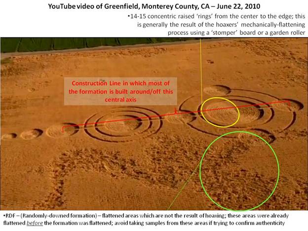
You can see areas which exhibit the tell-tale signs of the
mechanical-flattening process.
MUFON’s Chief Investigator Steve
Reichmuth listened to the sound of the helicopter in the video and
identified it as likely to be a 2-person Robinson helicopter – one not
likely to be a News helicopter. ICCRA’s Roger Sugden also made the same
observation independently suggesting a Robinson R22.
It turns out that the formation
WASN’T even in Greenfield, CA as the YouTube video purports, but rather
in Bakersfield, CA (140 miles away). It took a few days to figure this
out, but after the local sheriff in Greenfield confirmed that there was
no crop circle there, some additional sleuthing revealed that the rock
band Korn (who are originally from Bakersfield, CA), were responsible
for the formation. Korn hired the professional crop circle hoaxers from
www.circlemakers.org – led by John Lundberg with Wil Russell,
Rob Irving, and Mark Barnes – to construct the formation for the
band’s use in a music video and a live concert broadcast over the
internet. By July 5, The Circlemakers confirmed the news on their
website, followed with an official press release from Korn on July 8.
The original YouTube video
strategically edited out the Korn III logo for their upcoming album
which was also created in the field.
If one is cognizant of the
details of how the hoaxers methodically construct their imitation
formations, you can usually see these details readily in aerial photos /
footage, even among the most-experienced ‘professional’ hoaxer teams.
The way in which they mechanically construct their imitation formations
leaves behind these ‘artifacts’ or tell-tale signs of human
involvement. In this case, we were able to identify that this formation
had been hoaxed, strictly on the basis of the aerial footage – before it
was reported later that a professional hoaxing team had actually made
the formation.
Korn played their
live-on-the-internet concert from the imitation crop circle on July 11,
2010.
June
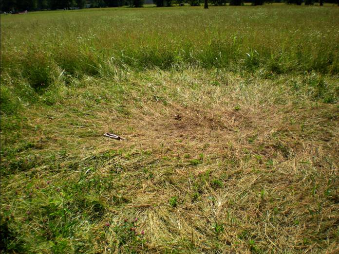
24, 2010 – Owensville, Clermont County, OhioSingle Crop Circle Goes Unreported in USA for Possibly 10 Months
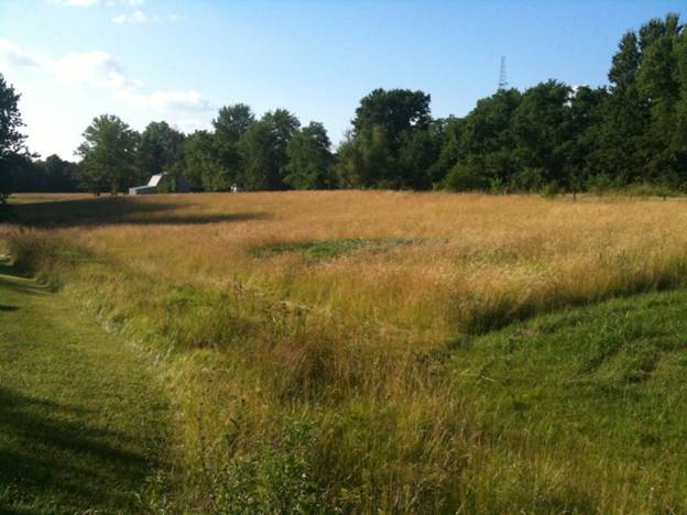
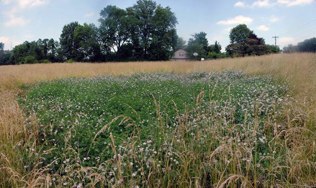
On June 24, 2010, I was taking
an alternative route home and happened to spot an unusual circle in a
grass field. Stopping the car to get a closer look, I snapped this
photo from the side of the road, which had a slightly elevated view of
the circle.
The area was clearly circular,
but sometimes it is hard to tell if what you are looking at is truly a
crop circle, so I walked down next to it to examine it a bit more
closely:
Above: Composite, panoramic
“fish eye” photo of circle
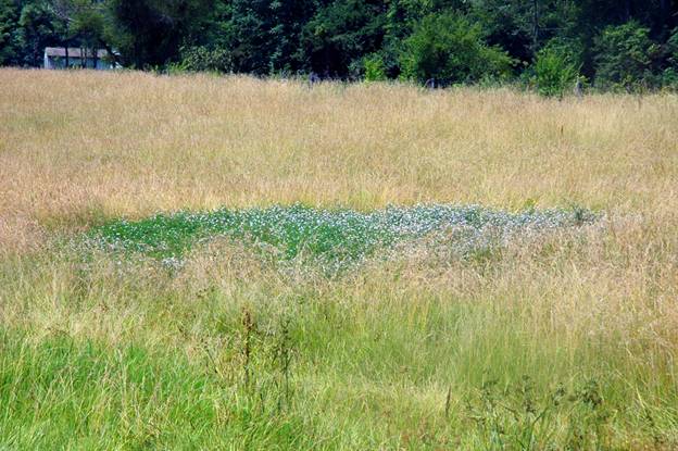
The circular area was of a
canopy of blooming flowers – Crown Vetch (identified later by my wife
Delsey, a certified Master Gardener). The growth of the Crown Vetch was
not as tall as the surrounding field grass. The circle is 26 feet in
diameter N/S.
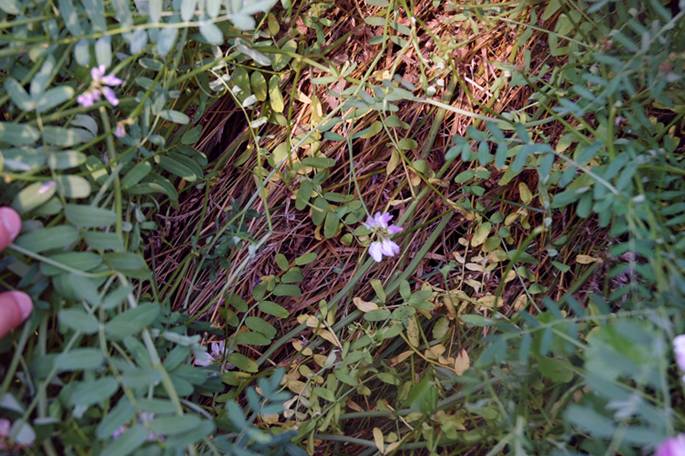
Pulling back the canopy of
flowers revealed my suspicions that this was an actual crop circle
though, as the field grass underneath was flattened and swirled down –
these Crown Vetch plants had grown up through the original flattened
field grass and created a canopy, not allowing the plants below to right
themselves:
Crown Vetch is not native to the
USA, although it is often used here for erosion control. It is actually
considered an invasive species by the IPSAWG (the Invasive Plant Species
Assessment Working Group) because of its ability to fully cover and
shade out native vegetation, particularly in grasslands.
One question we always have to
solve for in crop circle formation investigations is – when did the
circle occur? In this case it was evident that this circle was not
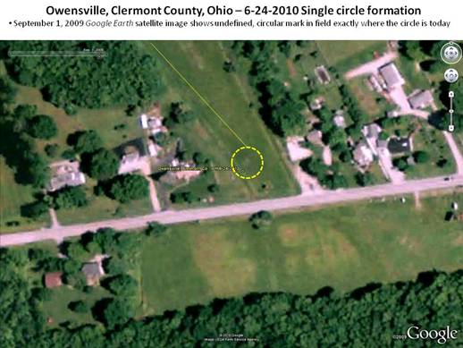
fresh, but exactly how old could it be? When I got home and mapped the
location of the circle in Google Earth Pro, I may have found a clue to
answer that question:
The mark in the field is
circular, and is exactly where the “flower circle” is today.
Unfortunately, Google’s satellite image isn’t particularly sharp for
this date, so we won’t know for sure, but it appears as if the circle
may have existed as far back as September 1, 2009. This would agree
well with the blooming Crown Vetch, as it usually does not bloom until
after its first frost season – if the circle arrived last summer, the
vetch could have begun then before winter arrived, and would be blooming
now for the first time.
Checking the Archaeological
Atlas of Ohio (W.C. Mills, 1914) interestingly reveals that in
nearly the exactly spot of where the circle is today, there once existed
an Indian mound (red triangle in the center of the map below; Stonelick
is the name of the Township):
I haven’t tracked down any
records to find out what happened to the mound yet, but this was an
interesting circle investigation nonetheless! Update: just a
few days after I had posted the details of this crop circle, the field
was harvested, and you can clearly see the circle remnants still left in
the field:
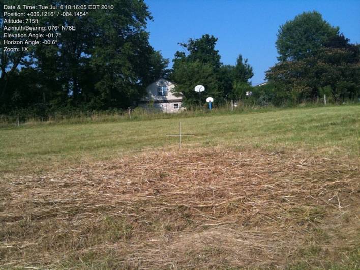
By the way, the above photo was
taken using the Theodolite Pro app for the iPhone – an amazing
tool which I’ll be using often for all of the orientation data it
collects and attaches to the photo – which I suspect will open up new
avenues of research in the years to come.
Sources: Jeffrey Wilson, ICCRA
investigation
Jeffrey Wilson, Director,
ICCRAΙ
Independent Crop Circle
Researchers’ AssociationΙ
www.iccra.org