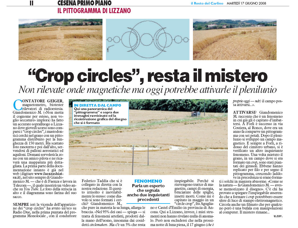
|
|

|
Lizzano, frazione Celletta (Cesena -
Forlě). Reported 12th June.
Map Ref:
This Page
has been accessed

Updated Saturday 19th July 2008 |
 |
| AERIAL SHOTS |
GROUND SHOTS |
DIAGRAMS |
FIELD REPORTS |
ARTICLES |

CLICK HERE FOR THE LATEST CROP
CIRCLE CONNECTOR DVD

|

Make a donation to keep the
web site alive... Thank you |
|
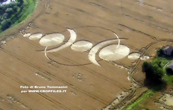
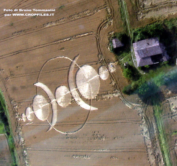
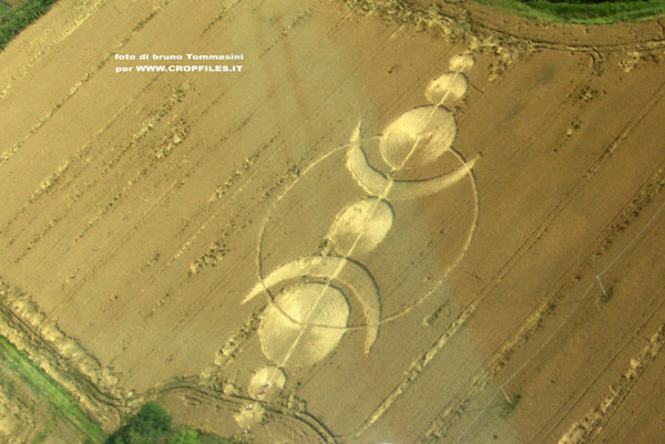
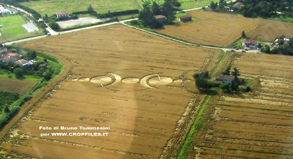
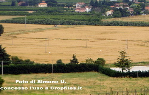
Ci scrive un nostro lettore,
Simone, dicendo di aver visto, il giorno 12 giugno, un “crop”
geometrico e di grandi dimensioni in un campo di grano. Nello stesso
campo, prosegue Simone: il giorno prima non c’era nulla; si
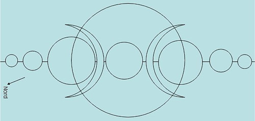
tratta di due cerchi sovrastati da due mezze lune; i cerchi hanno
anche un trattino che si collega alle mezzelune.
Si trova a Frazione “Celletta”, comune di “Cesena”, provincia “FC”;
rimane nel campo di grano antistante i campi da calcio; lo si nota
salendo la collina in un parco chiamato “Villa Silvia” di Lizzano.
Abbiamo chiesto a Simone di inviarci delle foto, e lui ci ha
accontentato (grazie!) |
|

FOR VISITING THE CROP
CIRCLES.
|
|
Come ci fa notare anche Simone, “non č
la prima volta che vengono avvistati in questa zona. Se ci fate caso, ogni due
anni (anni pari) appaiono in questa zona. La celletta č a poche centinaia di
metri da Lizzano dove avete giŕ segnalato altri cerchi. E aggiunge: non so se
c’entra ma č da alcune settimane che nella zona vicino al campo le stazioni
radio (radio FM) della macchina, risultano notevolmente peggiorate.
Sono molto scettico su queste cose ma quando vedo il disegno…[…] Mah..”
A presto per ulteriori aggiornamenti…. |
|


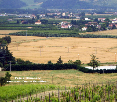
I
send you a new photos of Cesena's crop circles the exatly localiy
is "Celletta of Lizzano", in Cesena. Cesena, in Emilia Romagna,
ITALY. It formed in 12 juny 2008, near this street "via cupa". I
think probably it's "false circle", because is "simply", and had
some imperfections. But...? I stay in doubt... On this
crop I have edited a video on Youtube, search tags "ufo
cesena" or "crop circles cesena"
(I'm the guy with the Ray-ban...)
Wikingo


 |
|
A strange field orientation for the new crop
picture from Lizzano, Italy on June 12: can we explain it in terms
of the far-northern path of totality for an upcoming solar eclipse
on August 1?
A new crop picture from Lizzano, Italy on June 12
was nicely documented by local researcher Marina Sassi in terms of
field orientation and multi-layering of fallen crop (see
www.faenzashiatsu.it/crop/Cerchio%20Celletta.html). It was
seemingly meant to represent an upcoming solar eclipse on August 1,
2008, in parallel with three other crop pictures from southern
England on May 24, June 6 or June 9.
At Lizzano we have been shown the classic diagram for a total solar
eclipse: where some new Moon first produces a crescent shape for the
Sun, then a fully-eclipsed circle, then another crescent shape, as
it moves between Sun and Earth (see
http://eclipse.gsfc.nasa.gov/SEmono/TSE2008/TSE2008.html).
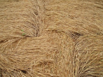
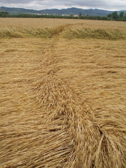
The most striking feature of that new Italian crop picture seems to
be a "long line" that runs through it from end to end, multi-layered
above other fallen crop. The field orientation of that long line is
reported to be 25-30 degrees east of north. How might that
relate to the astronomical location of our Sun on August 1?
Our Sun will reach maximum totality on August 1 at a far-northern
latitude of 70 degrees N in northern Russia
(see
http://eclipse.gsfc.nasa.gov/SEplot/SEplot2001/SE2008Aug01T.gif).
I therefore did some calculations using an on-line almanac
(see
http://aa.usno.navy.mil/data/docs/AltAz.php),
to learn where the Sun would be located on that day as seen from various
latitudes on Earth?
Latitude 70 N: sunrise 22 degrees, totality 149 degrees
Latitude 68 N: sunrise 32 degrees, totality 148 degrees
Latitude 51 N: sunrise 60 degrees, totality 138 degrees
What a surprise! The field orientation of our new Italian crop
picture seems to match the location of sunrise on August 1 for a
far-northern latitude of 68-70 N, where the Sun will reach maximum
totality! In England the eclipse will be seen as only 40% partial.
In other words, that new crop picture seems to be telling us:
"Look just east of north to see the Sun rise on August 1, then be
fully eclipsed by 10:21 in the morning".
But what about the other calculated value of 148-149 degrees, which
describes totality at 10:21 UT? Previously on June 6 at West
Kennett, another solar-eclipse crop picture appeared which showed an
anomalous field orientation of 160 degrees (plus or minus 10) as
estimated from Google Earth: see
www.cropcircleconnector.com/2008/westkennett/westkennett2008.html.
Its field orientation did not match well the sky location of
totality at 138 degrees in southern England near latitude 51 N, yet
now seems to match fairly well the sky location of totality at
148-149 degrees in northern Russia near latitude 70 N (see the
calculations above).
Red Collie |
|
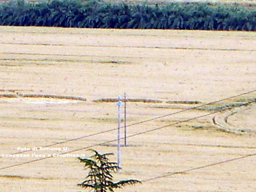
Localitŕ Celletta. Notato in un campo di
grano di un ente pubblico dal 12 giugno 2008. Da Sette Crociari
direzione Celletta a 70mt prima del cartello Celletta svoltare a
sx in strada Vicinale Cupa a 150mt a dx sbarra con casa colonica
pericolante sulla dx casotto con la formazione nel campo di 7
cerchi 2 semilune e una circonferenza che lega il tutto per un
totale lineare di 150mt
N 44° 07’ 18” E 12° 11’ 21”
Ecco il diagramma del Crop Circle realizzato rispettando le
proporzioni misurate sul posto. Questa simbologia ricorda
moltissime cose!!! I 7 Chakra con la piramide energetica
superiore e inferiore. Valerio mi ha ricordato il numero 17 e la
simbologia dei nativi americani "Cacina" (non so se scritto
giusto) il Grande spirito e i messaggi celesti. Ora aspettiamo
il 17 giugno nella notte ci sarŕ la luna piena e chissŕ il
Crop potrebbe sorprenderci!!!
THE CENTRE
FOR FURTHER INFO CLICK
HERE
Marina Sassi - Italy |
Click on thumbnails to enlarge
Click above to join the Crop Circle Connector
Membership
| AERIAL SHOTS |
GROUND SHOTS |
DIAGRAMS |
FIELD REPORTS |
ARTICLES |
|
|

BACK |

Mark Fussell & Stuart Dike |
|
 |


