I received a few more images from Mark Boring
of the Madisonville "Buzz" newspaper in Tennessee. In the 4661
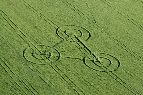
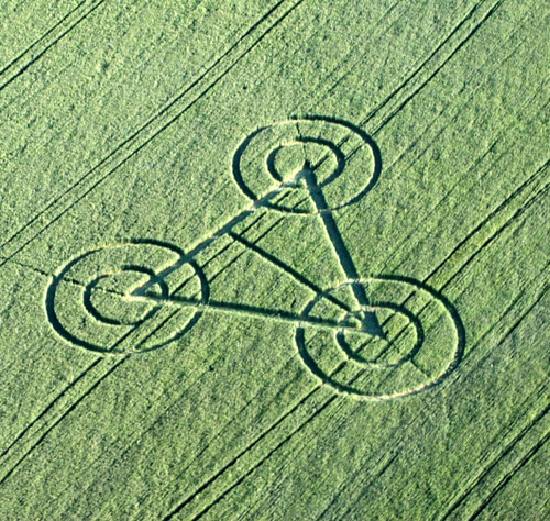
image, it appears that not all parts of the formation occurred
simultaneously -- you can clearly see that the triangle came
first, or that the rings that overlap the triangle came last,
because you can see where the flattened plants that create the
rings are overlapping the triangle pathway.
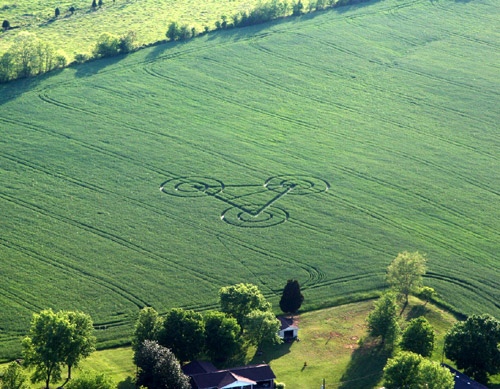
In the 4642 image, you can see there are
actually two pathways cutting across the field � one at the top
left of the image (entry?), and one at the top centre
(exit?). These pathways again could have been made by someone
just visiting the formation � not necessarily from any potential
hoaxers, so we�ll have to see if we can track the source of them
down. In the 4703 image, one pathway almost leads to the
pictured house adjacent to the field, it�s possible that the
track may be from the woman who reported seeing the formation
early yesterday morning � going out to visit it in a rush of
excitement and cutting across the field.
I checked the local weather � there was no
unusual weather Sunday night/Monday morning: it was partly
cloudy with a waning crescent Moon, and a low of 49 degrees F.
It did rain 0.18 of an inch Saturday night.
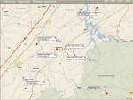
Click on map to enlarge
As ICCRA investigator Roger Sugden points out in the story,
there was a small earthquake on Sunday in the area:
Magnitude 1.6
Date-Time
� Sunday, May 04, 2008 at 22:23:53 UTC
� Sunday, May 04, 2008 at 06:23:53 PM at epicentre
Location
35.330�N, 84.150�W
Depth
12.4 km (7.7 miles)
Region
EASTERN TENNESSEE
Distances
� 14 km (9 miles) ESE (107�) from Tellico Plains, TN
� 26 km (16 miles) W (262�) from Lake Santeetlah, NC
� 29 km (18 miles) NNW (338�) from Murphy, NC
� 68 km (42 miles) ENE (75�) from Cleveland, TN
� 74 km (46 miles) SSW (195�) from Knoxville, TN
� 176 km (110 miles) N (7�) from Atlanta, GA
Location Uncertainty
horizontal +/- 1.6 km (1.0 miles); depth +/- 4.1 km (2.5 miles)
Parameters
NST= 9, Nph= 13, Dmin=17.4 km, Rmss=0.06 sec, Gp=184�,
M-type=duration magnitude (Md), Version=B
Source
� Southeast U.S. Seismic Network
Event ID
sehwb0504a
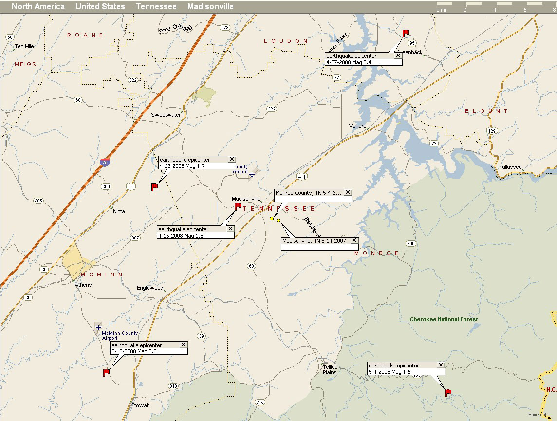
This was just the most recent of a number of
small earthquakes in the Madisonville area during the past
several months (see attached map) � I had called Roger a couple
of weeks ago when occurred in Madisonville that was also in the
1.8 Mag range just before the recent strong earthquake in
Illinois that shook the Midwestern states. The epicentre for
Sunday�s earthquake was approximately 16 miles from the crop
circle�s location. The one that happened when I called Roger on
the 15th of April was only 2.5 miles away from the
formation. There certainly has been a lot of small tectonic
shifts in the area, whether or not it is related to the crop
circle occurring there last year or this year.
I talked to Mark Boring this afternoon, and
he was just on his way out to look at the formation on the
ground. Hopefully we�ll see more photos and get more info later
tonight�
Here is the URL link for Mark�s story on the crop circle:
HERE
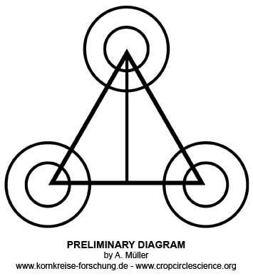
I've attached my schematic of the formation again, just in case
someone was still having trouble opening the earlier file.
More updates as I receive them -- all the best,
--
Jeffrey Wilson
Director, ICCRA
Independent Crop Circle Researchers' Association
#734.891.2689
jeff.wilson@roadrunner.comUPDATE:-
Monroe County Buzz,
113A Main Street, Madisonville, Tennessee (www.monroebuzz.com)
Mark Boring, 15 May 2008
�Clearly Man-Made Formation�
The recent crop circle that was discovered just outside
Madisonville ten days ago was determined by experts on Wednesday
�to be mechanically made by people.� Those were the words from
Jeff Wilson of Ohio, Director of the Independent Crop Circle
Researchers Association, at a seminar held Wednesday evening at
Donna�s Old Town Cafe, a gathering of around 40 individuals
including personnel from WVLT Channel 8, who listened to the
results of Wilson�s examination of a crop circle formation that
appeared in a wheat field off Rocky Springs Road on May 5.
�It is clearly a man-made formation,� Wilson said, comparing the
formation as he spoke to a previous pattern that appeared in
another nearby wheat field 12 months ago. In that earlier
formation we found elevated levels of radioactivity, increased
levels of electromagnetic energy, and evidence of microwave
activity,� Wilson said. �In this year�s pattern we found no
extraordinary energy at all.�
Wilson said that last year�s crop circle contained wheat plants
with enlarged stem growth nodes, an anomaly that did not
manifest in the second crop circle. He said it was �clearly a
man-made formation.� A former college instructor of physics and
astronomy, Wilson pointed out that several characteristics of
non-manmade crop circles cannot be duplicated by hoaxers.
�For one, you can�t fake radioactivity,� Wilson said. �Last year
the radioactive count inside the first circle was two to four
times the amount of normal background activity. And one sure
scientific test that separates man-made formations from those
not made by man is the measurement of lengthened growth nodes.�
The owner of the field, Johnnie Helms, was not happy when she
heard Wilson pronounce the crop circle as bogus. �I don�t like
it,� she said. �If I find out who did this, I will prosecute
them. Let me tell you, it better not happen again.� Wilson said
the wheat was green enough to recover however. �As a matter of
fact, we found it in a state of recovery as we took readings and
measurements yesterday and today."
|