CROP CIRCLES IN THE UNITED STATES IN 2007
07 Formations |
CROP CIRCLES IN THE UNITED STATES IN 2007
07 Formations |
Updated Wednesday 17th October 2007

|
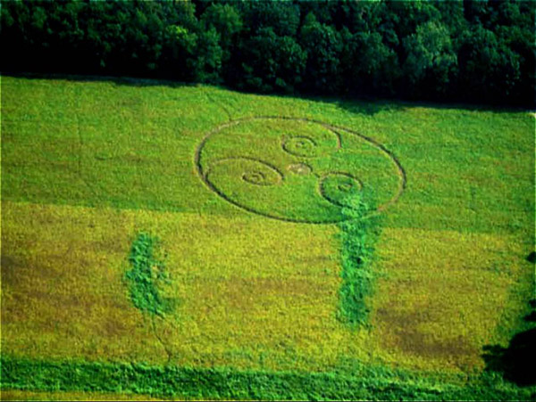
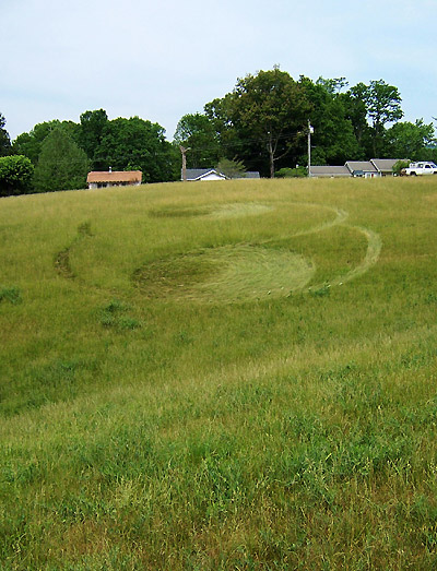
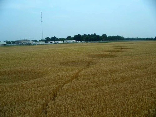
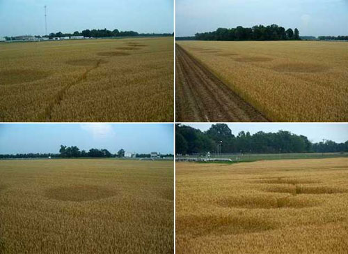
Wayne County, Nr Wooster, Ohio. Reported 23rd September. Thanks to Aaron Clark for passing this report on, and thanks Paul for sending it to Aaron – thank your pilot friend for taking the photos and for saying something to someone (most pilots don’t even usually look at the ground much, so we’re lucky there). If I may, let me re-insert one of the photos originally sent with some ‘cleaning up’ via photoshop (contrast/saturation enhancement):
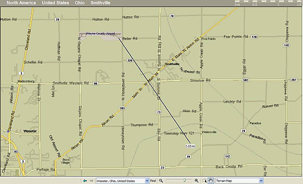
This allows us to see clearly that there appears to be a track into/out of the formation leading to the tree line. Someone has been inside this formation already. There haven’t been any news reports about it as far as I can tell. There also appears to be a pathway from the lower right spiral to the circle in the centre of the formation. This could have been made by the visitor (s), or it could have been part of the formation originally. The crop is soybeans, and it was already turning yellow at the time the photo was taken (at least two weeks ago). By now, chances are pretty good that all the leaves have fallen off the soybean plants – and there is a good chance that with the dry weather, the field could already be harvested. We might have a difficult time tracking down the location of this formation. Thanks Aaron for forwarding a link to the Google maps location. I’ve looked for possible matches with the tree line to find a possible location too, and it’s tough to say. There are several possibilities in the Google link you sent. Here is another map with the 3 miles SE estimated direction from the airport for reference:
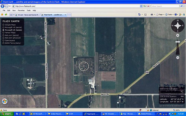
One interesting thing I found is that on one of the satellite views of this area there is some ‘artwork’ cut into a couple of fields (Rotary International logo, and a map of the state of Ohio with all the freeways):
So we also have someone in the immediate area who clearly is capable of crop artistry. In July of 2006, we investigated a hoaxed formation in soybeans in Sandyville, Tuscawaras County, Ohio, the adjacent county to Wayne County (where Wooster is located). That hoaxed formation location is approximately 30 miles from this location near Wooster. The Sandyville formation got quite a bit of press because of the boys who confessed to hoaxing it and were subsequently prosecuted. Could this formation be a copycat formation ‘inspired’ by last year’s, or do we have a serial hoaxer? Just a few questions to consider going forward… I’m going to try to contact the Wayne County airport today to see if anyone knows anything about the formation (perhaps seen by other pilots), and I’m going to contact the local paper there. Roger Sugden has offered to call the Sheriff’s Dept., to see if anyone has filed a report. Hopefully we’ll find a lead somewhere. Several of us are booked up already this weekend with prior commitments – is there anyone on the list who might have time to go over to the area and scout around? It’s been a pretty quiet year here in the USA, it’d be a shame not to track this one down. Jeffrey Wilson Director, ICCRA Independent Crop Circle Researchers' Association |
|
Location: Wilbur, Washington Found : June 29, 2007 Occurred: June 28, 2007 (?) Crop: Wheat Photo: Peter Davenport
On
June 30th Peter Davenport (National UFO Reporting Cener)
called BLT to notify us of this formation and his intention
to carry out some field examination of the plants.
According to Peter, the formation is approximately 150' in
length and width, with the plants laid counter-clockwise and
tight to the ground in all circles and in the centre ring.
So far we have no information regarding the presence of
elongated apical (top) nodes and/or expulsion cavities
(holes blown out in the plant stem nodes). Peter was
advised how to carry out a magnet drag (to look for magnetic
particles in the soils). Peter also reported that a local resident saw a bright flash of light in the general area of the formation on Thursday night (6/28) and that another local has been reported as having seen, and photographed, a "peculiar object" hovering in the area, reports which he will try to verify.
Although this formation is in a very rural area, with no houses nearby, word has spread quickly and already there have been multiple visitors (see tracks through the crop in the photo, above). The local paper (The Star) has now run a short article and indicates they will provide more info soon.
http://www.zwire.com/site/news.cfm?brd=1013&pag=460&dept_ID=387710
Nancy Talbott BLT Research Team Inc. P.O. Box 400127 Cambridge, MA 02140 (USA)
ph: 617/492-0415 web-site: www.bltresearch.com
Diagram Steven Vijverman Copyright 2007
|
|
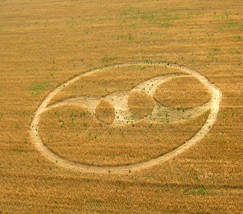
NEW CROP CIRCLE IN ARKANSAS Nancy
Talbott BLT
Research Team Inc. June
15, 2007
June 14, 2007 – New NE Arkansas Crop Circle (photo: Fred Martin)
Location: Northeastern
Arkansas (USA)
Discovered: June 14, 2007
Occurred: June 12, 2007
(?)
Crop: Wheat
(fully mature, but stunted)
We are very lucky to have been informed about
this formation in fully mature wheat, since harvesting has
already begun. BLT fieldworker JoAnne Scarpellini called the
office today from the site, where she is carrying out a basic
field examination, and reports some interesting details. There
are 4 tiny (18 inch diameter.) swirled circles inside the
standing sections on each side of the flattened "arms" which can
barely be detected in this photo. Also, one of the "arms" is
not flattened but is outlined with a "very thin" line
of laid crop on either side of what would have been the 4th
"arm"). The crop in the 3 flattened arms is all laid out
toward the perimeter ring. But the thin outlines of the 4th arm
(5-6 inches wide) are laid differently, both lines flattened in
toward the centre from the outer ring. The measured overall
diameter of the outer ring is 129 ft. by 132 ft., with the width
of the ring varying, overall being approximately 6 ft. wide. The formation is situated on a slight ridge
with homes belonging to two of the farmer's relatives about 200
yards. away. The field can be clearly seen from one of these
houses and, so far, we have not heard of anyone there having
observed anything unusual. However, a dog belonging to the
relatives in this home "went crazy" on Tuesday night (June
12-13), barking and waking the family in the middle of the
night. Interviews with the various family members have not yet
been carried out in-depth, so more information may be available
from them later on. This field was sown (rather than planted or
drilled) and there are no tractor-lines. No weed-killer was
applied during sowing so there are many weeds and
morning-glories (patches of green in the photo) throughout the
field. Jo-Anne reports that most of the weeds, etc. do
not appear to have been affected by whatever flattened
the wheat, and some of them are taller than the wheat itself.
[Because of very cold weather early in the growing season, the
mature wheat is stunted and only 14-16 inches tall.] This is the third formation to be found in the same general rural area during the last five years. In 2003 a pristine 3-armed, 10-circle "spiral type" formation was discovered in Knobel, Arkansas (also in mature wheat) by a local crop-duster.
une 6,
2003:
Knobel, Arkansas spiral-type formation, in mature wheat also. In 2004 the first U.S. formation that year--a
166 ft. diameter. "pinwheel" design--was found at Peach Orchard,
Arkansas (in wheat, just a few miles South of Knobel).
May 24, 2004: Peach Orchard, Arklansas "pinwheel" w/intact bird's nest in flattened crop. JoAnne found and photographed several intact birds' nests in the flattened crop at Peach Orchard, but earlier visitors to the formation prior to her arrival had removed what they reported as totally undamaged eggs from these nests. Because the farmer is harvesting this new
formation now JoAnne has to quickly take the various instrument
readings, carry out detailed measurements and gather samples,
and we will have to wait for a few days for more details which
may emerge from interviews with multiple near-by neighbors and
the field-work. The farmer has asked that the precise location not be made public as he is planting beans in this field as he harvests, and does not want to risk the new crop being damaged. Ground photos will be made available as soon as possible.
Contact info:
Nancy Talbott
ph: 617/492-0415
Nancy Talbott
BLT Research Team Inc.
P.O. Box 400127
Cambridge, MA
02140
(USA)
ph:
617/492-0415
|
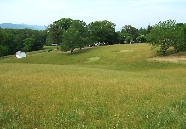
Crop circle appears in West Asheville
Images Danny Tetrault Copyright 2007
May 29, 2007 10:57 am It appeared over the weekend, intriguing local residents and begging the question: what is it? “I don’t know, man. I’m hoping somebody can check it out,” said Danny Tetrault, who lives in the area and noticed the geometric design this weekend. The pattern, possibly 100 feet or so long, looks like two interlocking circles, with small circles inside those. It’s a crop circle, which depending on your point of view is the work of alien spacecraft or mischievous pranksters wielding grass flatteners. Want to judge it for yourself? Here are directions: Go to Patton Avenue in West Asheville. Go past the Deaverview Road stoplight. Take a right on North Bear Creek (just after La Copa De Oro). Go over the tracks and up the hill. When you see a large hilly field on your left, park just before Hillside Drive on the left. You will see it from there. John Boyle Lindy Tucker made it to the crop circle yesterday and collected some plant samples and took many photos. She also made measurements with her Trifield meter - which showed nothing unusual. She noted many broken and smashed plants in the formation - and only a few people had been to the formation at that point. We'll see what the node measurements turn up, but it doesn't look too good right now... Jeffrey Wilson, Director ICCRA – Independent Crop Circle Researchers’ Association [International]jeff.wilson@asmnet.com or jeff.wilson@adelphia.net www.cropcirclenews.com 734-891-2689 (cell) External link from Citizen Times |
|
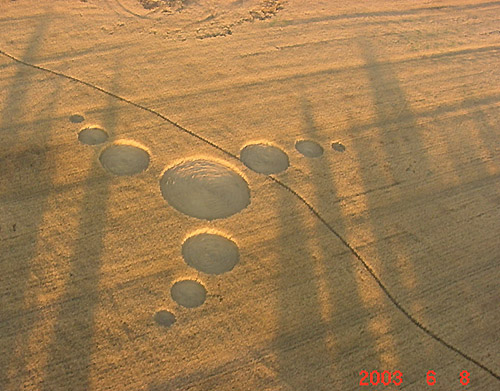
Crop Circle Reported in Madisonville, Monroe County, Tennessee
Early this morning
Mark Fussell from the Crop Circle Connector forwarded me an
email sent to him from Larry Sturgill regarding a reported crop
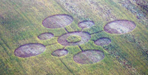
circle located in Madisonville, All formation photos © 2007 by Mark Boring, Co-owner and Editor, Monroe County Buzz The formation was first discovered on May 14, 2007 by the Monroe County Sheriff's Department by Patrol Captain Bryan Graves while he was flying. Mark Boring took the photo above on Tuesday May 22 through the plexiglass of the plane he was flying in during very hazy conditions. The formation is approximately 157 feet in diameter (square), is in wheat, and all the circles are swirled counter-clockwise. There appears to be some kind of triangular symbol etched into the central standing centre. Here is a preliminary schematic of the formation:
The large four outer circles are all approximately 41 feet in diameter; the central circle is 45 feet in diameter with a 19 foot standing centre (with the three small pathways creating a triangular shape; the four smaller circles are all 23 feet in diameter; the long pathways are all 15 feet in length while the shorter pathways are all 8 feet in length. The pathways out to the circles are actually flattened pathways and are part of the formation and were not created by visitors’ walking through the formation. There are no tramlines in this field, and when originally first sighted, there were no pathways at all leading into the formation. By the time Mark Boring took his photos, there was a pathway which led from the edge of the field into the circles. The area surrounding Madisonville is quite interesting for a number of reasons. From looking at a topo map, there are quite a few local place names that give some indication of the local geology and environment: Rocky Spring, Hopewell Springs, Tevis Spring, Reed Spring, Sweetwater, etc… Yes, the area is host to many springs! Also, Craighead Caverns is located next to Madisonville, and between Madisonville and Sweetwater is located a registered US Natural National Landmark called “The Lost Sea” which is a 4.5 acre underground lake in a cavern, claimed to be the largest underground lake in the USA. Yes, the whole area is pretty much all limestone! The area surrounding Madisonville is host to many, many archaeological sites, including one, Icehouse Bottom, which has been a habitation site for the past 9,500 year, making it one of the very oldest human habitation sites in Tennessee. Later cultures continued to use the site, and according to James B. Stoltman from the University of Wisconsin-Madison in his paper titled “Icehouse Bottom and the Hopewell Connection”, Stoltman presented a revelation that pottery shards found at Icehouse Bottom were characteristic of Ohio Hopewell Pottery, and that pottery discovered from within the Seip Mound and Harness Mound (part of the Liberty Earthworks) both located in the Paint Creek Valley in Ohio had the identical distinctive minerals and grain size as those produced at Icehouse Bottom – showing that over 2,000 years ago, those locations were part of the same extensive trading network. The area surrounding Madisonville also became the centre of the “Overhill” Cherokee culture, with many, many Cherokee towns and villages locating themselves along the Little Tennessee River and Tellico River. The town of Tanasi and later, the Great Echota, were considered to be the ‘capital’ of the Cherokee Nation. It was there that the explorer DeSoto, visited in 1540, probably one of the first white men the Cherokee had ever seen. Just to the south of the Madisonville crop circle site are two additional former Cherokee mound and village sites – the Great Tellico, which was also known to the Cherokee as “the mother city” and Chatuga, its ‘sister’. Here is a map of the Madisonville crop circle site along with all of these ancient archaeological mound and village sites:
Unfortunately, now nearly all of these ancient town and village sites are completely under water since the Tennessee Valley Authority dammed up the river to create several large lakes. Madisonville has more recently during the last few decades experienced many eyewitnesses seeing what is known locally as “the birdman” – I only have sketchy details at this point as to what this town has been seeing, I’m hoping to follow-up on that over the weekend. My wife Delsey and I, and most likely several additional ICCRA members will be traveling down to Madisonville, Tennessee this weekend to sample and survey the formation. Here’s one more photo from Mark Boring:
More details to come…stay tuned. Also, an additional crop circle has been reported from Mission, Johnson County, Kansas, discovered on May 21, 2007. Two small circles (approximately 8 feet and 6 feet in diameter) in grass:
The landowner has collected plant samples and has sent them to W.C. Levengood, who has already begun his analysis. Additional details to come on that formation too. Jeffrey Wilson, Director
ICCRA – jeff.wilson@asmnet.com or jeff.wilson@adelphia.net
www.cropcirclenews.com 734-891-2689 (cell) By Jean-Charles BOURQUIN |
|
Daily News photos by Rebecca Wolf Image Red Bluff Daily News Copyright 2007
Hello, my name is Dylan Darling
and I am a reporter at the Record Searchlight newspaper in
Redding, California. There have been some "crop circles"
found in a field about 30 miles south in Red Bluff,
California. I was wondered if there was a crop circles
expert I could talk to about them.
“Three crop circles could be seen in the field across the street from Helser Chevrolet on Adobe Road in Red Bluff Friday. Red Bluff police said they were aware of the circles but had not received any calls on the matter and were not investigating.”
I tracked down
the location of the field, and it is located alongside the Sacramento River:
I’ve contacted Steve Moreno (a founding member of the ICCRA) who is Director of PsiApplications, and Ruben Uriarte (ICCRA) who is also a MUFON CA state director. They are on their way to do an on-site investigation, so more details will be pending. Right now, the only details we have is that the crop circle was first reported on Friday, May 11, 2007 and that there are three circles in the field. Lots more work to do… Red Bluff, California is notable as being the location of where Ishi, “the last wild Indian in North America,” came out of the wilderness (just to the west of Red Bluff) back in 1911; Ishi was the last remaining member of the Yahi tribe. There were Indian mounds that were excavated in Red Bluff (the Tehama-Red Bluff Mounds) back in 1907, and there are more than 250 recorded ancient settlement sites along the Sacramento River in Tehama County. Red Bluff is located about 40 miles south of Mt. Shasta and 40 miles west of the Lassen Volcanic National Park. UPDATE:- I talked to both reporters involved with the Red Bluff, CA event yesterday, and Steve and Ruben are on their way. We should get much more info on this report later. The reporter who took the original photos estimated that the largest circle was 70 feet, but I’m not sure I trust that estimate yet. It also appears that the crop is hay – but that is also uncertain as she could not confirm. Linda Howe did a story on Red Bluff, CA back in January about there being over 30 cattle mutilations there on one ranch in Red Bluff during the past 10 years. More details to come…stay tuned.
Jeffrey Wilson, Director I happened to be in Ashland, Oregon when I found out about this formation. I was there presenting about "crystals, crop circles and earth energies" at the International Crystal Conference. No coincidences here! I decided to drive down and take a look. I've been in formations in your neck of the woods, but have never visited one in the US, so I was intrigued. The formation was in Oat, and had been harvested on the 18th (I was there on the 21st). However, I went in anyway, as I wouldn't miss it for the world :) I could only find the two largest circles, as the third and smallest was completely shaved from harvesting. Fortunately, there had been a good deal of trampling in the field before harvesting, so the lay that had been walked on had been preserved from the combine. The second largest circle had a radius of approximately 14 ft. I say approximately, because the farmer had laid the crop in lines to dry, and they ran directly through the centre of the circle, so I wasn't able to get an exact fix on the edge or the centre. Also, I was oddly disoriented in the
formation and needed to do the measurement a couple of times
to be sure. I was also measuring alone, so the tape was a
bit difficult to fix.
I also took measurements with my compass and found that magnetic north varied by 4 degrees to the east in this circle when I placed the compass to rest in the centre of the circle. In fact, I had to put the compass down, as it began to spin all over the place when I entered the circles. The crop had been well trampled, so some was saved from the harvester. I did collect samples of this, and found consistent bends of about 45 degrees in the third node, and in the fourth where they had escaped harvesting. While there were no out gassing holes, there was a slight brown burn scarring on the outside of these bright green bent nodes. The nodes on the oat in the circles was quite swollen. I'll take further measurements of the samples I collected, if that will help. I can also upload some photos of the oat samples, though they're a bit ragged. There were no similar markings, swelling, or bends in the crop outside of this or the largest circle. The largest circle was most discombobulating for me. I couldn't find a decent edge left from the harvester, so I finally gave up on a radius measurement of this circle. It appeared to have a radius of approximately 26 feet. The weird thing is that there appeared to be a variance of 6 degrees to the west in this circle (?!) when the compass was at rest in the centre(?) of the formation. I spent about an hour in the formation and was seriously surprised at the disorientation I experienced. I've been in large formations in the UK that had nowhere near the effect on me that this small series of circles had. There did not seem to be any difference in the soil moisture within and without the formation, as all was bone dry from the California weather. Another odd, yet anecdotal note; I experienced the same "buzzing" and vibration in my teeth that I often experience when driving under high tension power lines. There were no high tension power lines in the immediate area, though there is a large trunk line about 2 miles north. I wish I had been able to get to the formation when it was fresh, but I'm glad that I was at least able to get this for you, for what its worth.
Naisha Ahsian
|
|
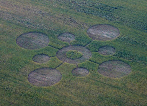
The above high-res photo was taken by the farmer, Ricky Graham, where you can see his track through his field (no tramlines), and through several of the circles. You can see where he crossed through the boundary of the circles he still made a track through the shorter wheat in the circles -- which looks to be about 3-4 inches shorter than the surrounding wheat. A local professor from Louisiana State University’s Agricultural Department was called out to look at this and he claimed it was the result of an elaborate hoax where someone had gotten in the field and put down a chemical to inhibit growth before the crops grew. I’m trying to get in contact with him to find out what evidence he has for this hypothesis. I’m not sure he did any testing at all. Hopefully more to come on this one too – it is unusual for sure – perhaps a bit like the Kansas ‘raised rings’ from last year?
Jeffrey Wilson, Director THE FIRST FORMATION was reported on May 10, 2007, by local TV-station NBC10 to have been discovered the week before from the air by local pilots. The formation is said to resemble „over 25 circles“ in a field of wheat at the village of Epps in West Carroll Parish in northeast Louisiana. Report by Andreas Müller -
www.cropcirclescience.org"
Video-stills showing
the circles in the field. The
original article on NBC10 reported
the following:
Aerial of “Poverty
Point” near Epps So far we do not
know what kind of analysis and methods have been used by the Ag
scientists at the site, nor if the team was aware of the state of
physiological crop circle sciences. |