CANADIAN CROP CIRCLES OF 2006 04 Formations |
Updated Thursday 7th September 2006
Discus Canadian Crop Circles on the Forum
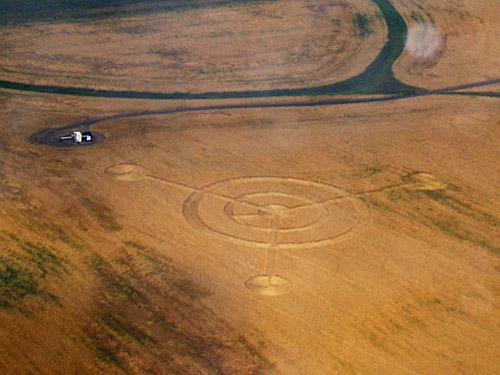
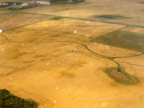
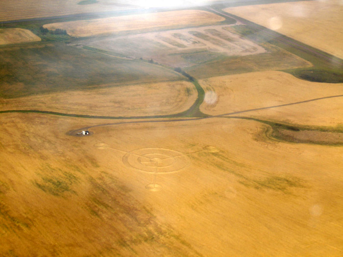
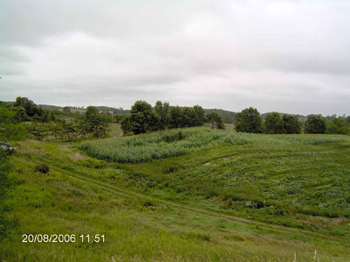
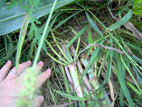
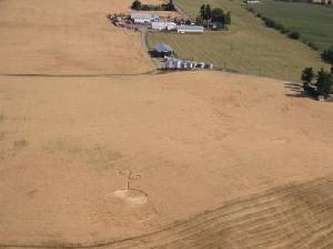
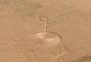
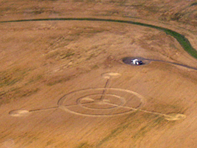
Formation Report #4 - Provost, Alberta

© Judy Arndt (CCCRN Alberta / Crop Circle Quest)
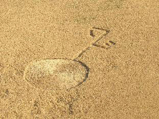
Cropped enhancement. © Judy Arndt (CCCRN Alberta / Crop Circle Quest)
|
UPDATE Just heard this morning from Judy Arndt (CCCRN Alberta / Crop Circle Quest) of a new formation near Provost, Alberta, found about September 1. The location is very close to the Saskatchewan border. Double-ringed circle with three straight arms coming out from the centre, ending in smaller circles. I've attached four initial aerial photos (two originals and two cropped enhancements by Judy). The "bols" in the original photos in this case, I think, are just dust or moisture on the plane window. Further details pending. Click on Thumbnails to enlarge
The formation was reported by Stacey Daley.
This is the fourth formation reported now for 2006.
I've also now posted the other ground photos of the odd Buffalo Pound
Lake formation, and the Kelowna UFO sighting report (re the Armstrong
formation) from Nancy Talbott, on the CCCRN web site.
Crop Circles in Canada 2006
Also...
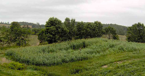
Update - Buffalo Pound Lake, Saskatchewan Formation
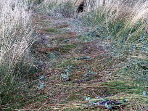
Additional ground photos have now been
posted, showing more of the
lateral sideways lay of the prairie grass within the long looping
pathway of this unusual formation (?). It has now been reported that
this is actually a dirt bike trail made in early July, with the grass
naturally falling over it in subsequent weeks. This could explain both
the uncharacteristic shape and lateral lay. Still under investigation.
Update - Armstrong, British Columbia Formation
A report has been posted (Details page) regarding a reported sighting of odd lights in nearby Kelowna, in a similar pattern to that of the formation, around the time that the formation was first found. |
Buffalo Pound Lake, Saskatchewan, found on August 20
|
UPDATE 2
Images Lynda Anderson Copyright 2006
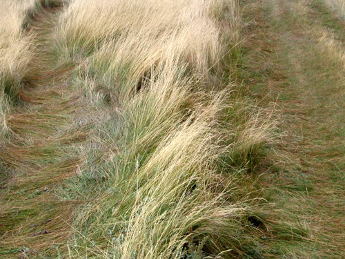
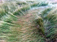
The lateral sideways lay of the grass (including in small "bunches") can
be seen in much of the pathway, including in narrower parts (in these
photos), as well as wider parts, such as the turns of the lobes (see
again previous ground photo already posted). It looks like some of the
"bunches" may be flattened in opposite directions, from the outer edges
of the pathway toward the centre, but not certain yet. That reminds me
of one of the formations I visited near Midale, Saskatchewan in 2001,
the "backwards 7", in which all along the length of the top bar of the
7, the wheat was flattened in small bunches like "criss-crossing Xs",
again all laterally across the pathway and from the outer edges toward
the centre.
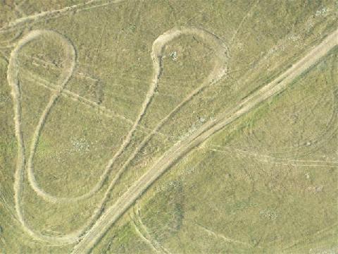
In the second photo (b), the formation pathway on the right (note the
"bunches" here) is almost touching the adjacent normal, and wider, trail
on the left, in the lower "bottom" of the right lobe of the formation
(see again the aerial photos already posted). Here the formation is
almost exactly tangent to the trail. The first photo (a) is looking
toward the far end of that same lobe.
I will add them to the CCCRN web site shortly.
Lynda also noted to me that this formation is not in the Buffalo Pound
Park area itself (beside the lake), but a few miles south of that, in a
more secluded area of pasture land. The other normal trails seen in the
photos are not "official" hiking or biking trails, such as are in the
park.
The grass is also now starting to spring back up more from when they
first found the formation on August 20.
It was suggested to me a couple days ago that this is nothing more than
a trail made by dirt bikes. Maybe - if it was just an ordinary flattened
path cutting through the grass as seen from the air, I'd be more
convinced, but the details on the ground don't look like it to me. Lynda
said they didn't notice any tire tracks going into the pathway, with no
ground indentations or "dug up" plants, plus with the type of lay
pattern seen, I'm not sure how likely this would be? Perhaps some grass
could have fallen over an older existing pathway, but that is only
conjecture. We should know more later this week though...
This formation can now be added to other web site archives, as it is now
on the CCCRN web site also (with initial diagram and other photos). I've
classified it as one for now at least, as it is flattened and
semi-geometric. Still odd, though.
UPDATE 1
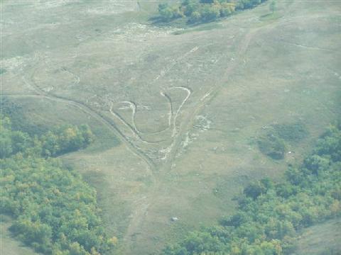
Just a quick update. Here are two aerial photos of the unusual "double-lobed" formation. Thanks to Lois Baillie (CCCRN Saskatchewan) for getting the local pilot, Wally Meili, and Kel Vizco to fly over yesterday. Larger versions are on the web site now.
The formation is situated between two converging dirt roads, near the
lake. The shape even fits into the 'V' of the two roads. The ATV tracks
going across were not there before.
Looking closer in Photoshop, I can see the lateral lay of the grass
across the pathway (per the previous ground photo), especially in the
"lobes"; more difficult to see in the thinner parts of the pathway. The
pathway widens in the "lobes" and bottom curved parts of the formation.
Judy Arndt (CCCRN Alberta) also noted that the lateral lay is similar to
that seen before in some RDA (random) patterns, yet there is a clear
near-symmetrical shape to the formation. I could more easily see someone
doing something like this in a normal manner, but why would anyone
bother to make such a long pathway by flattening it laterally? I don't
recall seeing anything with quite this weird kind of shape before,
either.
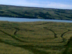
Just heard of an unusual formation near Buffalo Pound Lake,
Saskatchewan, found on August 20. Reported by Lynda Anderson.
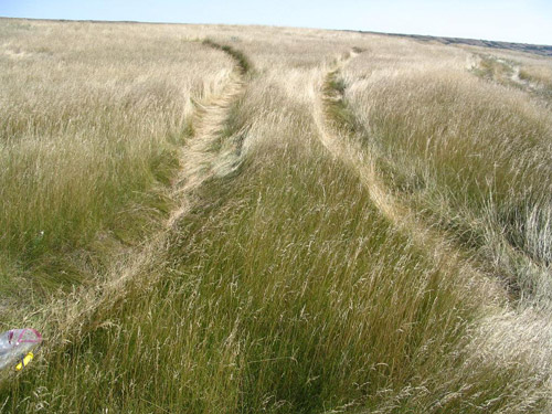
A "double-lobed" pathway in tall prairie grass. The one "lobe" is about
150 feet long, the other about 180 feet, according to initial
measurements. The pathway is about 2 feet wide, with some variability.
I've included two photos below I just received that Lynda's son took.
They are just smaller sized ones right now, until she can send the
full-sized ones (having computer problems). Lois Baillie, our CCCRN
representative for southern Saskatchwan, will be able to go there after
she gets back from her trip. This is near her, just north of Moose Jaw.
She also knows a pilot in Moose Jaw, who can hopefully take aerial
photos soon. I don't know when or if I can yet still, because of an
awkward work schedule right now, and this is a long ways from where I
am.
Note how, in the close-up ground photo, the grass is flattened across
the pathway. In places along the pathway, there are also smaller swirls
about 8 inches across or so. The odd shape of the formation is evident
in the other photo, even this smaller version for now.
The lake is near the formation, in the first photo.
The whole formation is a single, continuous pathway, just not quite as
clearly seen in the smaller photo. Since the length of each "lobe" is a
double pathway as such, there is roughly at least 660 feet or so of
actual flattened grass altogether (150 feet x 2 + 180 feet x 2), not
including the other flat section connecting the two lobes (not sure of
length yet, looks to be similar though), which could make it closer to a
1,000 foot-long pathway of laterally-flattened grass in total.
The other "pathway" between the formation and lake is just a trail where
vehicles used to go, according to Lynda.
I was trying to think of a possible prosaic explanation, but don't know
what to make of the weird shape combined with the lay pattern...?
It reminds me of that smaller 48-foot long and 1-foot wide oval ring in
Alberta in 2004, also flattened similar to this, in pasture grass.
|
|
Update (2) - Armstrong, British Columbia Formation. 12/08/2006
|
A new (and better) aerial photo
has now been posted on the CCCRN web site. Taken by a pilot who first
saw the formation on July 31. The second pilot, as previously reported,
saw it on August 2. Also, for anyone who may have seen it, please note the commentary on the blog regarding errors in the local, but widely circulated, article in The Province newspaper on August 10 regarding this formation: http://www.theprairiecircular.blogspot.com The blog format has been updated a bit more also. Comments-enabled for feedback and Atom news feed available! |
Update (1) - Armstrong, British Columbia Formation. 11/08/2006
|
Some ground photos have now been posted. The crop is barley, not hay or grass as initially reported. Investigation is still on-going by CCCRN British Columbia. The farmer does not want anyone entering the field without permission. Plus an interesting synchronicity... |
|
First Canadian Crop Circle Formation of 2006
Images Ron Franzmann Copyright 2006 Near Armstrong, British Columbia. Circle with branching pathways, in hay (?). In the Okanagan Valley region, where reports are typically very rare. Spotted by a pilot on August 2. Further details pending. This is the first known and reported Canadian formation for 2006 and the first BC formation since 2004 (none reported last year). Thanks to Darren Handschuh (Kelowna Daily Courier) and Brian Vike (HBCC UFO Research) for their assistance. CCCRN News Formats Just a reminder that the primary format of CCCRN News is now html (styled text and graphics). If you wish to change to text-only format, please advise by sending an e-mail to: The Meridiani Journal On a brief non-crop circle related note, for those who are interested in space exploration, astronomy and related subjects, a primary interest of mine my entire life, I also have a new blog, The Meridiani Journal: The Meridiani Journal is a blog about planetary exploration and the search for life elsewhere, both in our own solar system and beyond. The name is derived from the desert plains of Meridiani Planum on Mars, where the Opportunity rover landed in January of 2004 and is still going today, providing the first on-site confirmation of ancient salty playa lakes and groundwater on another planet... While I had started it initially last fall, I have recently had more time to work on revamping the format. Many recent updates regarding fascinating findings including the still-going Spirit and Opportunity rovers on Mars, methane rain and lakes on Titan, huge water vapour geysers on Enceladus and more... Paul Anderson This is the html (styled text and graphics) format of CCCRN News To change to text-only format, send an e-mail to: cccrnnews-text@telus.net To unsubscribe, send an e-mail to: cccrnnews-unsubscribe@telus.net |
| Location: | |
| Crop: | |
| Description: | |
| Discovery: | |
| Name: | |
| Status |