|
Code: SUSSEX 2004/05
Location: TEGDOWN HILL, HOLLINGBURY, NR BRIGHTON, EAST SUSSEX
First reported: 30th June 2004
Crop: Barley
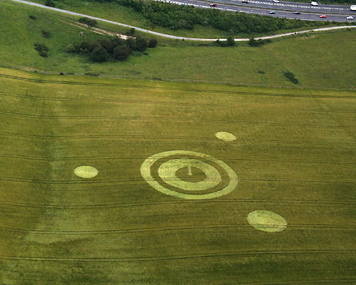
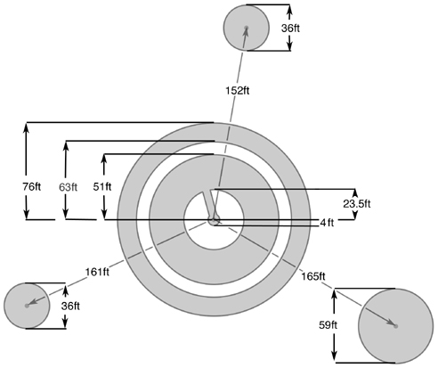
Design: Double-ringed circle with central path and three satellite
circles Dimensions: Around 300ft total diameter
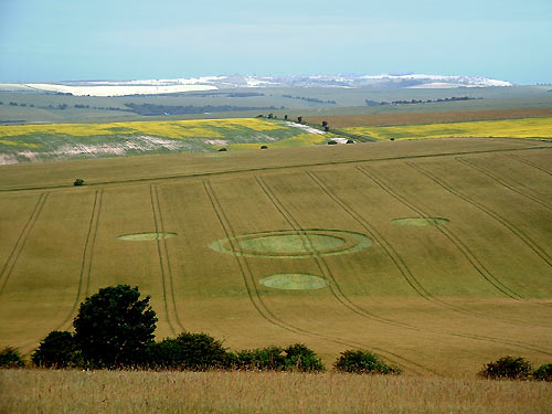
REPORT: In contrast to the astonishing floral
pattern which appeared in the same field last year, this new formation
has the retro-look of a late 1980s triplet design. It is clearly
visible when looking west from the road which runs from Brighton across
to Ditchling Beacon, and makes a fine sight in the landscape, though
some feel it is rather uncomfortably situated when compared to its
predecessor.
The main ringed section is 152ft total diameter,
with a small 8ft central circle, while two of the satellite circles
were originally 36ft and one 59ft, although the smaller satellites then
grew in diameter on the night after its appearance, to match the larger
one... On the same night, the entire central area, originally
containing a smaller ring with a path leading to its centre, was then
obliterated to make a much simpler design.
Aesthetically, the formation leaves something to be desired (it
actually looks better after its second night conversion). Though some
of the swirls on the ground are neat and impressive, particularly in
the satellite circles, lay elsewhere in the circle is less good and
shows clear signs of the 'banding' which some believe is created by
manual planking methods, although others have put forward other
theories to account for this. The lay throughout all the components is
clockwise.
The design is in a spring-sown barley which has not yet reached
maturity, so the crop is still fairly pliable. However, the downed
crop shows signs of kinking, splitting and breakage. Positioned on a
fairly steep slope, the lay is noticeably flatter on the downside than
it is on the upside, as if the flattening process struggled on the
climbing stretches, but rallied on the easy downhill runs.
Before its unexpected removal on the second night, the 23ft avenue into
the centre of the formation was rather scruffy, and the very centre of
the formation, as well as being somewhat flat and lifeless, showed
traces of a bare indentation in the soil.
Interestingly, a camper had pitched tent at the very edge of this field
on the night of the pattern's appearance. He says the formation was
not there when he zipped up at 10.00pm, but it had appeared by 5.00am,
when he emerged. He awoke briefly at about 2.50am, but remembers
hearing nothing, although it should be noted that the formation was
several hundred feet away. This story was recounted on a full page of
the local newspaper 'The Argus' on 1st July. The same man was still by
the field on the night the 'amendments' were made, and again claims he
heard nothing.
The farmer, who just days before had appeared on
local radio and TV appealing to people on behalf of the National
Farmer's Union not to enter fields to look at crop circles (!), has
once again requested that visitors refrain from entering the field.
ANDY THOMAS & ALLAN BROWN
Southern Circular Research
|