|
|
|
Stonor House, nr Pitslhill, Oxon/Bucks. Reported 4th August.
GPS Reference
Updated Monday 13th November 2000
 |
 |
 |
Creation Date: Circa early August
Map Ref:SU733905, SU734905, SU736905
Crop: Wheat
Reported by: Liz Illwood
Image(s): To Follow. NOTE: These are 3 separate formations. These are the aerial shots we obtained. Click to enlarge.
Dimensions/Swirl: Large Formation. 200ft diameter circle containing a 170ft equilateral triangle.
Dumbell formation: 3x 30ft circles with 10x5ft passageways interlinking the circles and 3 spurs, 1 coming out of each circle.
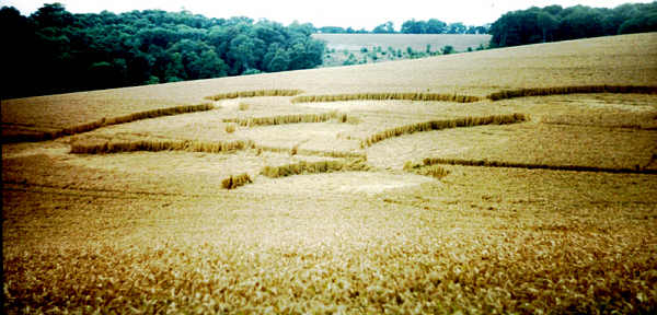
Other formation: 150 ft square consisting of central circle with circle, oval, circle, oval pattern surrounding single circle.
There are also some grapeshot in the same field
Description and Information: See Below
The central formation has been extensively visited from the Oxfordshire way pathway and has been
vandalised by paint spraying of the crop. A more thorough survey will be under taken shortly.
Description and Information: See Below
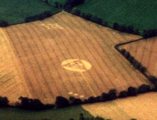
A remarkable discovery of 3 formations in one field originally spotted by one of our contact pilots, Liz, and
over flown on August 7th. The field was nearly a mile from the nearest built up road (B 480) and had to be approached on foot from the Oxfordshire Way path. It certainly would never have been found without aerial
observation. The crop was wheat and still green in places in spite of the date around mid-August.
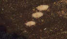
FORMATION (I): Nearest the access path comprising the Oxon/Bucks border - this was a double dumb-bell of 3 approx 30ft circles with 10ft x 3ft and 16ft x 3ft
linking paths. Two of the circles had raised centres. All circles had 2, 12ft x 2ft spurs emanating at right angles to the main axis. The formation was at 45 degrees to
the tram lines. SU 733 905.
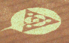
FORMATION (2): A very large 200ft diameter circle positioned in the centre of the field with a raised equilateral triangle of 170ft sides within. Smaller features were
flattened inside the triangle consisting of 4 smaller circles 23-25ft diameter and interspersed with 3 "humped" crescents about 60ft long. Very complex flows in the
flattened wheat were observed. A 10ft wide straight path lead directly from the very centre of the formation to the edge of the field, a distance of 500ft. This had the
appearance of being flattened by a roller, but energy was detected all along the length. A few feet further down the field a similar straight path ran from the track into
the field but did not reach the circle (A mistake?) Seed heads in parts of the design appeared to have been sprayed with turquoise blue paint in the centre of the
formation - both standing and flattened. This was assumed to be vandalism. SU 734 905.
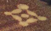
FORMATION (3): Positioned in a dip on the far side of the field, this was an unusual interlocking array of 4 circles and 4 ovals surrounding a small central circle
making a linked square. The circles were 33-51 ft diameter and the ovals approx. 60ft x 30ft. The central circle appeared to be joined by paths to the ovals although
these may have been trampled. It was unclear at which angle to view this formation, but one of the 4 outer circles was about 10ft wider than the rest, so if this one is
considered the top we get a diamond shape. Again some of the ears were found to be sprayed with a muddy brown coloured paint and ash was found in the centre
of the formation indicating human activity, but bearing in mind all the circles in this field indicated energy was present and the total isolation of the spot, there would be
plenty of time to indulge in illicit activities after the events had occurred. SU 736905.
Note all formations appeared equally aged but it cannot be established if all appeared on the same night.
Reported by Howard Amble. 
|
|


