|
CROP CIRCLES IN 1999 |
|
|
CROP CIRCLES IN 1999 |
|
Morcott, nr Barrowden, Leicestershire. Reported 29th June.
Updated Tuesday 18th October 2005
GPS Reference SP9221499833
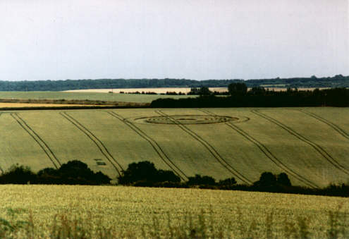
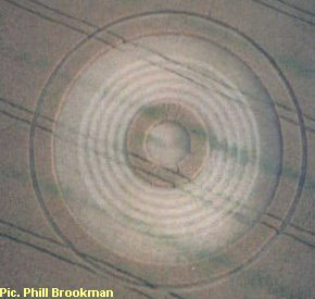
Photo © N. Nicolson 1999.
View from footpath near A47. Crop forming spiral still standing. 5th July 1999

|
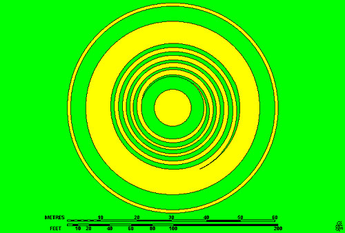
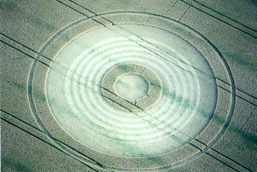
Photos © P.J. Brookman 1999. Air View: Crop Forming spiral flattened. 17th July 1999. CROP FORMATION IN RUTLAND, 1999. 6. MORCOTT, EAST OF UPPINGHAM. Grid Ref: SP 922 999 ON A47 LEICESTER - PETERBOROUGH ROAD. FIRST REPORTED SIGHTING: 2 July 1999. LOCATION: West side of B672, 0.4 miles south of junction with A47 at Morcott. Visible across a small valley from a footpath leading south opposite a motel on north side of A47. FARMER: Egerton Gilmon, tel: 01572 823 476. Steve Pyrah telephoned this number which he was given by someone he met in the village, hut the reception he got was not friendly, and he did not get permission to enter the formation. DESCRIPTION: This formation showed a very interesting development during its observed lifetime. On 5th July Nick Nicholson took a telephoto shot from across the small valley which gave a view obliquely downwards on to the formation. It clearly shows the rings of standing crop within the outer circumference forming the spiral. On 11th July Steve Pyrah entered the circle for a short time, took some dimensions by pacing and found the spiral still standing. On 17th July Phil Brookman took a series of eleven air shots of excellent quality while circling the site on his Microlight. They show that at some time after 11th July the standing spiral had been flattened to the same level as the surrounding area. The laid spiral appears on the photos as lighter in tone than the rest of the laid area. It is clearly and crisply defined, even to the outer tail end, which diminishes evenly to nothing. The first lay was clockwise, and close inspection of the photos shows that the second lay was made in the opposite direction. The following dimensions are estimated from the air photos, assuming that the tractor track = 5.5 ft. Centre circle diameter. 25ft. Standing ring width 10.70.ft overall diameter. of standing ring 44ft. Width of large laid ring containing spiral 36ft. overall diameter. of large laid ring 127ft. Width of standing ring 11ft. Width of narrow outer laid ring 3.2ft. 0/a diameter. of formation I 57ft. Width of spiral track 3.7ft. Pitch of spiral 5.9 ft. Number of turns of spiral: 5. CROP: Wheat, approaching ripeness.
Centre for Crop Circle Studies : East Midlands Branch Tony Caldicott, Branch Co—Ordinator, 514 Moor Road, Bestwood Village. Nottingham NG6 8UN. Telephone: (0115) 979 5333. |
|
Mark I have checked out the formation it is a multi ringed circle spreading across almost three tramlines, it was first seen on the morning Sun 29th June. Located as you enter the village from Leicester on the right of the A47,opposite a Texaco garage. If you miss it you are blind. Images to follow. I have been informed of a formation at Morcott on the A47, it is 200ft and in wheat, I think Michael Newark will visit shortly. Reported by Nik Nicholson. (The Circular Review).
Location : Morcott. South of Leicester
Ordnance survey grid reference : SP 92214 99833
First seen : 27 June 1999
Courtesy of
Steve Pyrah
|