Huish Hill, Nr Oare, Wiltshire. Formed 4th July.
Updated Wednesday 8th July 1998
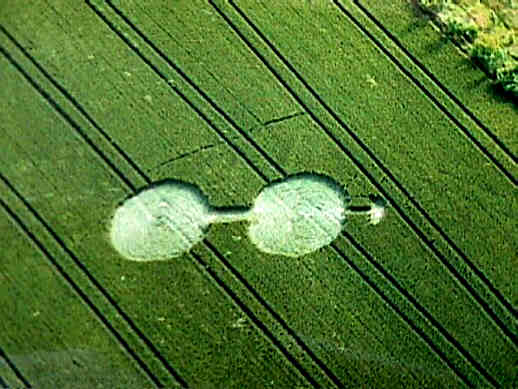
Image Copyright 1998 Colin Andrews
Field Report
Click on thumbnail to enlarge
Image Copyright 1998 Stuart Dike
What a fantastic location this rather cute Dumbell formation is set in!. It was a pleasure to visit this formation, which in itself was highly impressive, with a floor pattern in Wheat a class above anything else I have seen around Avebury.
Oare is a pretty Wiltshire village, located below an escarpment of hills, laden with ancient Earthworks. The hillside is the same range as Adams Grave and Knapp Hill, were many crop fields are grown below. This particular field was located to the north of the village, below Huish Hill, and what a position to have a formation!. There are many wonderful locations around the Avebury area were formations occur, but this has to be one of the best, hidden away from the main road, in a quiet area between Oare and Huish, which is the next village.
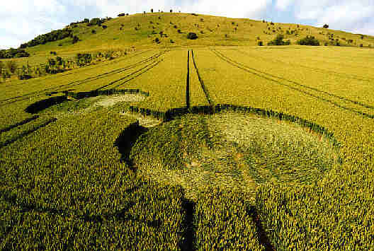
The formation was just under 100ft in length. A classic early nineties style Dumbell, with what appeared to be a "Hook" or Head? positioned at the top of the formation. The design was placed on a North West direction, running across three tramlines, facing towards Adams Grave in the distance.
The floor pattern was a dream! It was so neat
in its construction, that you felt guilty actually walking on it. It had the classic four
directional centre spread, in the bottom circle, (which apparently has a solitary Poppy
flower growing in the middle) There was no evidence of this, it may have been taken away,
or snapped off?
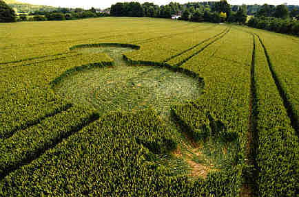
The bottom circle had a number of standing tufts in the middle, but both circles were beauties with regard to their spiralled patterns. They were flowing in a anticlockwise rotation, with the central avenue flowing into the second circle, and then flowed into the circle itself, turning to the right, in unison with the circle lay. I am in no doubt that as the avenue were being flattened the circle was being flattened at the same time, this is why we see these multi layering within formations.
The top feature was very strange, it was like a pickaxe, or "Hook" which was only about 10 feet across. It just stopped before the third tramline, with a small wall of crop separating each other. The avenue leading to the top feature, was flowing in the opposite direction, down towards the top circle.
Click on thumbnail to enlarge
Image Copyright 1998 Stuart Dike
The entire formation had many stems on the outer edges that were positioned 45 degrees to the standing surrounding walls. This was an indication, that the formation was flattened extremely quickly, indeed the whole of the formation had a wonderful fluid quality to its floor construction, like running water. Many of the designs around Avebury are too mechanical in their construction, this one stood out from the crowd!!!
The top circle was slightly larger than the
lower circle, only about a couple of feet difference. An unusual magnetic anomaly was
witnessed by people within the formation, when one of our American contributors to the
Connector, used my own compass, and found a two degree difference off North, as you stood
on the end of the avenue flowing into the top circle. In fact three people including
myself had the same effect. Could this be something to do with possible Ley Lines running
through this
formation? The formation hasn't being dowsed as of yet, but it would be interesting
to know.
A wonderful small formation, set within an impressive and beautiful location, and magnified what a privilege it is, to be researching this phenomenon!
Report by Stuart Dike.

