Updated Monday 29th September 1997
Images by Andrew B S King.


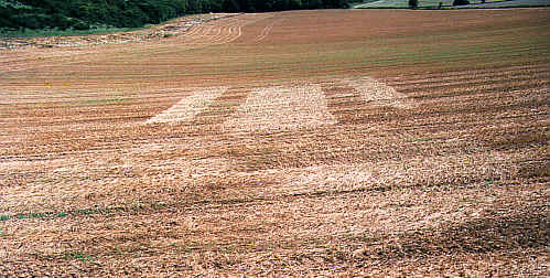
There were actually three. The third, smallest, formation was right in the westernmost corner of the field and was probably not visible from the hillside. First to appear was the "axe-head"-within-circle, followed a couple of days later by the two "spaceship" pictograms. The location is properly known as "The Gliders". The farmer gave permission for a survey on the understanding that this would be put on record in exchange. He was very emotional about the subject, since the hill was used by both British and German glider pilots for training in the pre-Second World War years, and several lost their lives there.
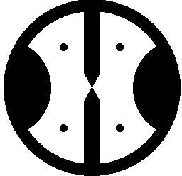
The attached gifs show the circular formation "buck1", the larger of the similar pictograms "buck2" and the smaller (about 80' long, with a 35' circle) - "buck3".
Report and diagrams by John Sayer.Copyright 1997
Date seen: 27th July 1997 2:30 PM
Type of grain: Rye
Location: North of Buckland, Surrey. About 200 meters from North Downs Way between Dorking and Merstham. A few hundred meters after the path turns 90 degrees from north towards east (in the direction towards Merstham). Map on page 54 in National Trail Guide North Downs Way.
Description: I saw two crop circles.
1) A circle with diameter 58 'feet' (my own feet), a kind of rectangle with round corners that touches the circle, one narrow rectangle on each side of the first and parallel to it.
2) A ring shape, two arches cut into the middle part, two 'Gothic church window' shapes that meets in the CENTER of the ring, four small circles in the middle part in between the arches and 'Gothic church window' shapes.
Reported by Knut Oftedahl.
First there are 2 circles in the same field, not just one. All are quite well visible from the North Downs pathway, just down from the chalk scarp.
No1.
large circle swirled clockwise, 58 feet in diameter, CENTER slightly offset. 'Below' i.e.
to the East of it, by some 6 ft. are three bars, 9' apart, of thickness 9',20' and 9'; all
starting with flat tops and swirled anticlockwise at their bases; the outside (9' wide)
bars are about 80'long, the CENTER one 72 'long. About 30 ' from the tops there is a
diagonal joining path, sloping up to the central bar, 7'wide.
No 2
This one is located further into the field and consists of an open circle 6'wide swirled
clockwise. Attached, diametrically opposed, to the inside of the circle are two
semicircles, 18 and 20'across their widest parts, both swirled clockwise. Diametrically
opposed at right angles to the semicircles are two bars (about 6'wide) which both taper to
a point at the centre where they almost touch. The distance between this centre and the
widest parts of the two semicircles is 20, and 22' making the circle about 94 feet in
diameter. Placed in the 4 segments between the bars and semicircles are 4 grapeshot,
6'diameter, the North-easterly one swirled clockwise, the others anticlockwise.
I have taken some photos from the scarp, but since this was after harvest they will not show the formations clearly. --
ADDITIONAL REPORT
At Buckland the farmer again thought both formations the work of hoaxers - and indeed there may have been some additions if both were not entirely man-made. The formation closest to the downs had an uncanny resemblance to the Starship Enterprise! although the more distant formation was quite original. It was difficult to assess the 'quality' of the lay after harvest but measurements were made, as reported earlier.
Reported by Andrew B S King.

