Updated Sunday 11th August 1996
Roundway, Nr Devizes, Wiltshire (2nd formation). Reported 20th July.
Crop Type: Wheat

An aerial shot by Steve Alexander. Copyright 1996.
An aerial shots by Lucy Pringle Copyright 1996.
Field Report

Click on thumbnails to enlarge
Images by Roeland Belijon and Nancy
Polet.
Copyright 1996. Thank you Jan
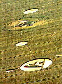
Situated on the very top of Roundway Hill, a second formation appeared from the Dumbell just down the road.
This time the circlemakers decided to include an isolated Tumulus as part of a line of two circles and a symbol formation. Because of the location, they can not be seen from any advantage points, not even when your standing on the edge of the field.
The Plantation is the nearest point of reference to the groupings of circles, and placed opposite is the Pig Farm, located the other side of the track which runs all the way to Furze Knoll.
The set of three circles, including the Symbol, intrigued me greatly, because of the location, and the alignment with the Tumulus. The symbol design had one of it's accompany circles situated the other side of the Tumulus, as if to say that the ancient burial mound played a key part in the positioning, and maybe the actual source.
The Symbol placed inside a circle, is at the moment unrecognisable to people, and is very hard to describe. If I was to guess, then I would say it resembles two forks, of 'F's joined together. A pathway was surrounding the symbol independent to the main floor pattern of the circle. Overall the construction was very well executed.
The floor pattern inside the symbol, was made up of small eddies, and sweeping flows. They were done with extreme accuracy, and control, and the same applies to the small design which was separated from the circle. It resembles a Spear Head, and included three centre nests, with a outer flow surrounding them. The Spear Head was about 16ft in length.
The main circle with the symbol inside, was approximately between 76-80 feet in diameter. The Symbol shape was about 40 feet across. It was placed at an angle inside the circle, producing a triangular design.
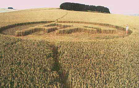
The first accompanying circle, next to the symbol formation was even more fascinating. It's floor construction implied some kind of outward force, which resulted in the floor pattern forking itself into the standing crop on one side of the circle only. In some ways it reminded me of the single circle below the power lines in 1995 directly below these circles.
The central sway, was offset by atleast 10ft, as the dimensions from one side of the centre was 23ft, to 10ft the other side, making the overall diameter 33 feet. This circle seemed to be about 250ft from the Symbol. The outward motion of the forking of the plants, was so great that it pushed the standing wall over slightly, but it was only visible on one side of the circle.
Placed the other side of the Tumulus, towards the Plantation, was a another accompanying circle, this time with a totally different floor pattern to the other. It was very carefully flattened, with an overall diameter of 51 feet. No forking into the standing crop was evident, and the standing wall of the circle was 90 degrees to the floor pattern. This circle was slightly offset from the tumulus, so if you were to view them from the air, this circle would be out of line to the rest. The Tumulus seemed to be of a similar diameter to the accompanying circle, but I didn't get the chance to measure it, or to dowse if a lay line was present. I'm pretty sure a line does actually go through the circles, and the Tumulus.
Overall a very intriguing set of circles, pleasantly located on this dramatic hill, with commanding views of the home countryside for the Crop Circles.
Report by Stuart Dike.

