Updated Monday 30th September 1996
An aerial shots by Steve Alexander. Copyright 1996.
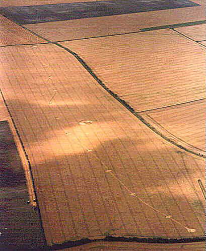
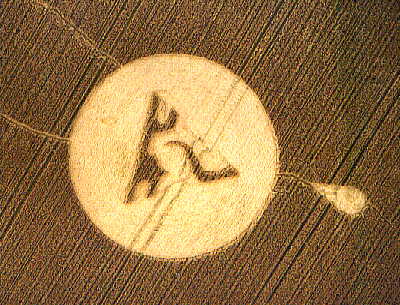
The formation is 8/10 of a mile long and consists of 14 circles with a single pathway. The Central circle has a glyph inside similar to the Roundway formation of a week earlier.
Crop Type: Wheat.
This event, if you can call it that, appeared below the slopes of Etchilhampton Hill near Devizes. It stretched from one side of the field to the next, and was at least 3/4 of a mile in length.
It comprised of a single pathway only about 5ft in width, with Twelve circles placed at certain points along the path. The pathway itself meandered on it's journey to the other side of the field. Quite rough in appearance, the side of the pathway was jagged and not uniformed, this extended all the way to the other side.
The start of the pathway consisted of a tear drop circle, flowing into the pathway itself. Interesting feature to the tear drop was that the pathway started from the back of the shape which flowed through the central section of the shape.
Placed to the side of the pathway, and about half way down the field, a second event of the symbol designs appeared. Positioned inside a single circle, this design was a progression from the Roundway Hill Symbol, but seemed out of proportion to the circle itself. Completely separate from the pathway, the Symbol contained another Tear Drop signature.
The circle was flowing clockwise, with intricate details of Crop lay producing the shape. A small band of crop could be seen tracing the Symbol around it's perimeter, with a small spiralled circle placed within the shape.
Positioned at the end of the pathway on the other side of the field was a singled ringed circle, with the pathway itself flowing into the circle from one side. This produced a 'comma' design with the circle and ring flowing anticlockwise. Each circle was attached centrally to the path and swirled clockwise and were almost identical in detail to each other. The pathway flowed through the centre of each circle.
A Comparison between the glyph at Roundway and Etchilhampton.


Click on thumbnails to enlarge
Roundway. Etchilhampton.
Pole Shots by Stuart Dike. Copyright 1996


Click on thumbnails to enlarge
We are missing several circles in the path, can someone please help us with these images?
Daniel Nightwolf, Ph.D.
Copyright 1996 by Daniel Nightwolf
e-mail: nghtwolf@frii.com

Image by Daniel Nightwolf. Copyright 1996.
The Etchilhampton formation consists of 13 circles connected by a long, serpentine path, a single Grapeshot connected to the second circle from the northernmost end, and a separate Glyph circle with a nearby Teardrop formation. If the circles are numbered from the southernmost circle (and the circle which, by far, represents the easiest entry into the formation), then Circle One has the shape of a bulb (as in the base of a thermometer), and a width dimension of approximately 34 feet. The lay of the crop is in a circular, clockwise direction, except for a five foot wide path which extends from the southernmost edge of Circle One (Figure 2) to Circle Thirteen's northern edge where it circles it.

Click on thumbnail to enlarge
Image by Daniel Nightwolf. Copyright 1996.
Circles Two through Twelve are roughly the same size with diameters of about 28 feet. Each of these circles also has a clockwise crop lay, with the exception of the five foot wide path crossing the centre of each circle. Circle Twelve also has a Grapeshot tangent to it (Figure 3). The Grapeshot has crop lay in a counter-clockwise rotation, along with a teardrop shaped centre piece with dimensions of approximately two foot by three foot. The point of the teardrop points away from Circle Twelve. The Path from Circle One to Thirteen is unbroken and does not vary in width (even though it meanders somewhat along the length of the field).
Circle Thirteen is radically different from the first twelve circles, with the Path entering the circle tangentially and rounding a larger circular, thin crescent which in turn surrounds a portion of a large inner circle (see Stuart Dike's photos). The inner circle has a diameter of about 47 feet, while the outer diameter measures approximately 66 feet. Notably, the lay of the wheat crop in Circle Thirteen is counter-clockwise.
The Fourteenth or Glyph Circle (see Stuart Dike's photo) is separate from the other thirteen circles. It may have been created at a different time, but is incorporated within the overall design. The Glyph Circle's outer diameter is in excess of 90 feet. Adjacent to the Glyph Circle is a Teardrop shaped circle which appears to point toward the midpoint of one side of the triangular shaped glyph. The Teardrop dimensions are approximately 12 foot (at its widest point) by 27 foot (in length, toward the triangle).
The Glyph Circle encloses an equilateral triangle, which has been shaped into a relatively unique form. This triangular shaped form is apparently only the second one of its kind (to date), with the first glyph appearing one week earlier in the third circle of a formation found on the ridge just above Roundway (also near Devizes), and both shown in Stuart Dike's photos. Both glyphs are based on an equilateral triangle (57 feet on a side), with circular and curved sections being "carved out" of the basic triangle. In addition, both triangles include a central circular formation which both the triangle and circle are centred upon. Both glyph circles are also accompanied by a teardrop of about the same dimensions (27 feet in length, subtending an angle of approximately 36 degrees). Both teardrops are located at two distinct distances from the Glyph circles, but both are offset from the centreline of the equilateral triangles by some 13 1/2 degrees of angle. All three of the Teardrop dimensions and location are important (see below). Each of the Teardrops have three centres (based on the crop lays) laid out along the longitudinal axis, and each of the three centres are separated by a distance of approximately 7 feet.
The tram lines in the Etchilhampton field run north and south and at least one of them appears to be important in the overall design. Circle One is accessed easily from the south by a tram line which curves into it at the south end of the field. The access is, in fact, so easy, one might suspect a visitor was being encouraged to take a specific path into the formation. Circle Two, meanwhile, is intersected by the next tram line to the west. Circle Three is between the fourth and fifth tram lines, Circle Four between the fifth and sixth tramlines, Circle Five between the sixth and seventh, and Circles Six, Seven and Eight are between the seventh and eighth tram lines. Significantly, Circle Nine has its eastern edge lying tangentially to the sixth tram line, while Circle Ten is intersected by the same tram line, and Circle Twelve lies tangent to the sixth tram line in the same manner as Circle Nine. The Grapeshot attached to Circle Twelve is also tangent to the sixth tram line, but is on the eastern side of the tram line. Circle Eleven is between the fifth and sixth tram lines, and Circle Thirteen has its western most edge tangent to the sixth tram line. The Glyph also has its western most edge tangent to the sixth tram line. The Sixth tram line, in effect, connects many of the circles, and appears to be important -- a consideration specifically mentioned by Michael Glickman at the Glastonbury Crop Circle Symposium during the weekend of the appearance of the Etchilhampton formation.
One speculative interpretation is that the first twelve circles and the connecting paths in the Etchilhampton serpentine formation represent the twelve chakras -- with the unique Circle Thirteen being the completion of a pathway progressing through the first twelve chakras. In this case, the connection between Circle Thirteen and the Glyph Circle via the sixth tram line, makes the Glyph Circle appear as a supplement to the twelve chakra pathway. In addition, the sixth tram line can also be viewed as a dividing line between left and right brain functions (conscious thinking versus subconscious feeling), and in this case the location of the circles to either the right or left (when looking at the formation from the South) corresponds to the left/right brain characteristic of the circle which corresponds to its respective chakra. The Glyph and Teardrop, as well as the Grapeshot of Circle Twelve are also located on the right brain side, although the Glyph and Grapeshot are both tangent to the sixth tram line. This suggests that the path completion at Circle Thirteen may allow additional access to the meaning of the Glyph, and all three of the formations may communicate subconsciously by symbology.
This idea of a "Path" running between the circles is supported in part by the energy surges which can be experienced in walking the length of the 0.7 mile formation (and then doubling back along the sixth tram line to the Glyph Circle). This author walked this Path on four separate occasions and can attest to a energising, joyful experience. Also curious was the fact that the varying slope of the field prevents anyone walking the Path from catching the slightest glimpse of the Glyph Circle until they have just reached Circle Six (and thus the sixth, "Third Eye" chakra). Circles Eleven, Twelve and Thirteen are also hidden by a rise, and cannot be seen even from Circle Ten.
Curiously, an astrological interpretation of the probable time period of the creation of the Etchilhampton formation includes several Sabian Symbols [2] which appear to be relevant to the speculative interpretation just discussed. These Sabian Symbols include: "Men travelling a narrow path, seeking illumination", "Walk on", "A carrier pigeon fulfilling its mission", and "Pilgrims climbing the steep steps leading to a mountain shrine."
During the weekend of the apparent appearance of the Etchilhampton formation, the Crop Circle Symposium at Glastonbury was considering among its many topics, the idea of a 13-13 vibration. This was mentioned particularly by Darryl Anka during the Saturday night program. The Etchilhampton formation clearly has 13 circles in the main sequence, with the one Glyph circle enclosed a three pointed, equilateral triangle. If the latter is thought of as a one and a three (on circle and three sides of a triangle), i.e. 13, then the overall Etchilhampton formation comprises a 13-13 formation. The timing of the appearance of the formation, may also in some manner correspond to the Glastonbury Symposium, and may in fact also relate to the exact timing of the Saturday Night Program.
Other speculations include a three-dimensional one, which would suggest two more such glyphs (as a minimum) in addition to the glyphs at Etchilhampton and Roundway Ridge in order to complete a three-dimensional tetrahedron. This would allow for an intriguing and thought-provoking exercise, to say the least, in piecing the pieces of the puzzle together. Yet another alternative is to use the CENTER of the circles/triangles, and spin the designs in the same manner suggested by Patricia Murray at the Glastonbury Symposium. In this regard, it may be useful to note that the centre circle of the Etchilhampton Glyph has a counter clockwise crop lay, and the Roundway Ridge Glyph has a clockwise crop lay.
The spectacular, "awesome" formation at Windmill Hill (just west of Avebury) and which was formed during the same weekend as the one at Etchilhampton, is apparently connected to both the Etchilhampton and Roundway Ridge formations as well as several other formations of the 1996 season.
For example, David Percy, Richard Hoagland, and others have shown that an overlay of the Cydonia Region of Mars (a complex of craters, pyramid-like mounds, and the so-called "Face on Mars"), corresponds to the 1) Avebury stone circle, 2) Silbury Hill, 3) a small tree-lined burrow located a hundred yards north of the highway from Avebury to Devizes (marked on the Ordnance Survey Map, Landranger #173 as a single "Tumuli"), and 4) a longer outcropping of trees associated with "earthworks" farther to the west and north of the burrow (marked on the Ordnance Survey Map as "Knoll Down"). The fascinating part is that a line drawn from the Windmill Hill formation to the Etchilhampton formation passes through the burrow, while a second line drawn from the Windmill Hill formation to the Roundway Ridge formation passes through the "Knoll Down" trees. In fact, in one of Stuart Dike's pole shots of the Windmill Hill formation, the "Knoll Down" trees can be seen in the left centre background, running along the ridge. In addition, the line from Windmill Hill to the so-called "Snowflake" at Oliver's Castle also passes between the "earthworks" and the "Knoll Down".
But this is only the beginning.
A line drawn through the "Vesica Pisces" formation at Ashbury and the "Opposing Crescents" formation at Chiseldon -- if extended to the south-west -- passes very near the old Iron Age fort at Barbury Castle, then directly through the Windmill Hill formation, and ultimately to the "Snowflake" at Oliver's Castle. Significantly, this line makes a 36 degree angle with a horizontal east-west line. Furthermore, if the Ashbury/Windmill Hill line is referred to as the 'base line" (and which may correspond to the "Mary and Michael energy ley lines"), then a second line from Windmill Hill to Roundway Ridge makes a 9 degree angle with the base line (and therefore makes a 45 degree angle with a horizontal east-west line). At the same time, the Windmill Hill/Etchilhampton line makes a 27 degree angle with the "base line", a 27 degree angle with north-south (and therefore a 63 degree angle with east-west), and an 18 degree angle with the Windmill Hill/Roundway line.
It's worth mentioning at this point that the teardrops associated with both glyph circles in the Roundway Ridge and Etchilhampton formations are 27 feet long, and both subtend an angle of 36 degrees! In addition, the angle between a line drawn from Roundway Ridge to the "DNA" formation at East Field (Alton Barnes) and a line from Etchilhampton to the DNA formation, is also 27 degrees. The same 27 degree angle exists as well, between a north-south line and the line from Etchilhampton to the Stonehenge "Julia" formation! The Windmill Hill/Roundway Ridge line passes through an earlier crop circle at Roundway ("The Dumbbell"), which is located slightly south-west of Roundway Ridge. Not unexpectedly, the angle between a line drawn from the Dumbbell to Etchilhampton, and the line from Etchilhampton to Roundway Ridge is 27 degrees!
The deviation from north-south by a line from Etchilhampton to Oliver's Castle is 36 degrees, while a line from Windmill Hill to Oliver's Castle makes a 13.5 degree angle with the line from Windmill Hill to Glastonbury. This 13.5 degree angle is, of course, half of 27 degrees, and is also the angle the teardrops deviate from the triangular glyphs at both Etchilhampton and Roundway Ridge! In fact, the Etchilhampton/Alton Barnes line makes a 13.5 degree angle with the east-west line, the Alton Barnes/Barbury Castle line runs 13.5 degrees east of north-south, and the Alton Barnes/Chiseldon (the "Opposing Crescents" formation) is 13.5 x 2 = 27 degrees east of north-south.
Many of these angles, as well as several others, are shown on the accompanying map. Of particular interest is a near-equilateral, isosceles triangle connecting the northern tangent of Windmill Hill to the base-line between the Roundway Ridge and Alton Barnes formations. The angle at Windmill Hill is 66.6 degrees (within what appears to be a justifiable accuracy), while the base angles are 56.7 degrees each. The latter is important in that both glyphs at Etchilhampton and Roundway Ridge include an equilateral triangle whose sides measure approximately 57 feet. A. Mueller carefully measured one of the glyphs in meters, which when converted to feet, yielded 56.7!!
If one looks at an aerial view of Circle Thirteen in the Etchilhampton formation, one cannot avoid seeing the shape of the number, nine -- very much, in fact, similar to "9". Nine is typically viewed esoterically as "completion". But the interesting factor is that all of the numbers shown in the accompanying map, reduce to 9!! For example, 27 and 36 degrees each yield a 9 (27 = 2 + 7 = 9; 36 = 3 + 6 = 9). But so does 13.5 = 1 + 3 + 5 = 9; 56.7 = 5 + 6 + 7 = 18 = 1 + 8 = 9; 66.6 = 6 + 6 + 6 = 18 = 9; etceteras. Also shown on the map (in green) are also distance measurements -- all of which reduce to 9 as well.
While the degree of accuracy is difficult in some cases -- due to the inaccuracy of determining exactly where a particular crop circle is located -- one might suspect that the angle of deviation from a north-south line by lines drawn from Stonehenge are: to Alton Barnes, 3.6 degrees, Windmill Hill, 9 degrees, Chiseldon, 11.7 degrees, Ashbury, 20.7 degrees, and Roundway Ridge, 23.4 degrees. With improved accuracy, one can measure the deviation from north-south of the Windmill Hill/Alton Barnes lines as 19.8 degrees.
Finally, one might also keep in mind that the Etchilhampton formation, because of its length is limited in where it can placed. This leads us to suspect first that the formation at Roundway Ridge was located with foreknowledge of the Etchilhampton formation, and secondly, because of the multiplicity of geometric, nine relationships, that all of the formations mentioned above are part of the same planning!!
Now. Is this fun or what!?

