|
CROP CIRCLES OF 1983
|
|
|
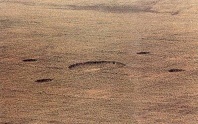
Chicklade, nr Salisbury, Wiltshire.
This is a real treat I've found. It is a Crop Circle
from 1983. The little boy in the front is my five year old brother
Mike, my father Roger took the photo in Chicklade where we all lived at
the time. I haven't seen this one anywhere else. Chicklade This name is one of a small number in Wiltshire where a Welsh and a Saxon word are combined to construct one place-name. This may indicate that the place had a pre-Saxon name to which has been added a Saxon one, or that a pre-Saxon word entered the vocabulary of the early Anglo-Saxon settlers. In this case the two words are the British ceto, Welsh coed (wood) and the Saxon hlid (gate). It first appeared in 912 in the form Cytlid, by 1232 it had developed into Chicled and in 1279 appeared in the very recognisable version Chikkelade. What is now called Great Ridge was in 1348 originally named Chicladrygh (Chicklade Ridge). Bocklerley Hill may derive from the Saxon bocleah (beech wood). In the case leah may have been used with its older meaning of 'wood', rather than in the sense 'clearing'. This last meaning is one that developed in the later Anglo-Saxon period. Fonthill Bishop The name Fonthill, first recorded as Funtgeall, in 901, is mixed Saxon and Welsh. It combines Saxon funta (water-channel) and Welsh ial (fertile uplands). For another example of ial see Deverill. The Saxon word funta may have been borrowed from the Latin word fontana. Fonthill Bishop shares its name with Fonthill Gifford and Fonthill Brook. It is close to Teffont Magna, Teffont Evias and near Fovant. All are derived from 'funta' and this concentration of funta place-names, near two Roman roads, suggests that there may have been a survival of Roman water management here and that a Latin term may have passed directly to Saxon settlers. 'Bishop' shows land was owned by the church. My words: In Chicklade village there is a little old church, and there was once a priory there. The church has a circle (now not complete) of Yew trees signifying a Bronze age worship site. Also the A303 is very straight in the main and goes past Yarnbury on to Stonehenge, this may have Ley line possibilities. There is a Roman road in the Great Ridge Wood, which then joins the A303 or it joins the Roman road, as it came first, they used to eat the snails from here, and the Wessex Ridgeway runs through Chicklade. So this is an ancient settlement, and a major thoroughfare, the Little Chef and the Old Rectory the last two eateries left, previously there was more than pub here as coaches and their horses used to stop off here prior to the age of the car. Clare Kingston |